Signal No. 4 in 9 areas as Pepito weakens into typhoon over Nueva Vizcaya

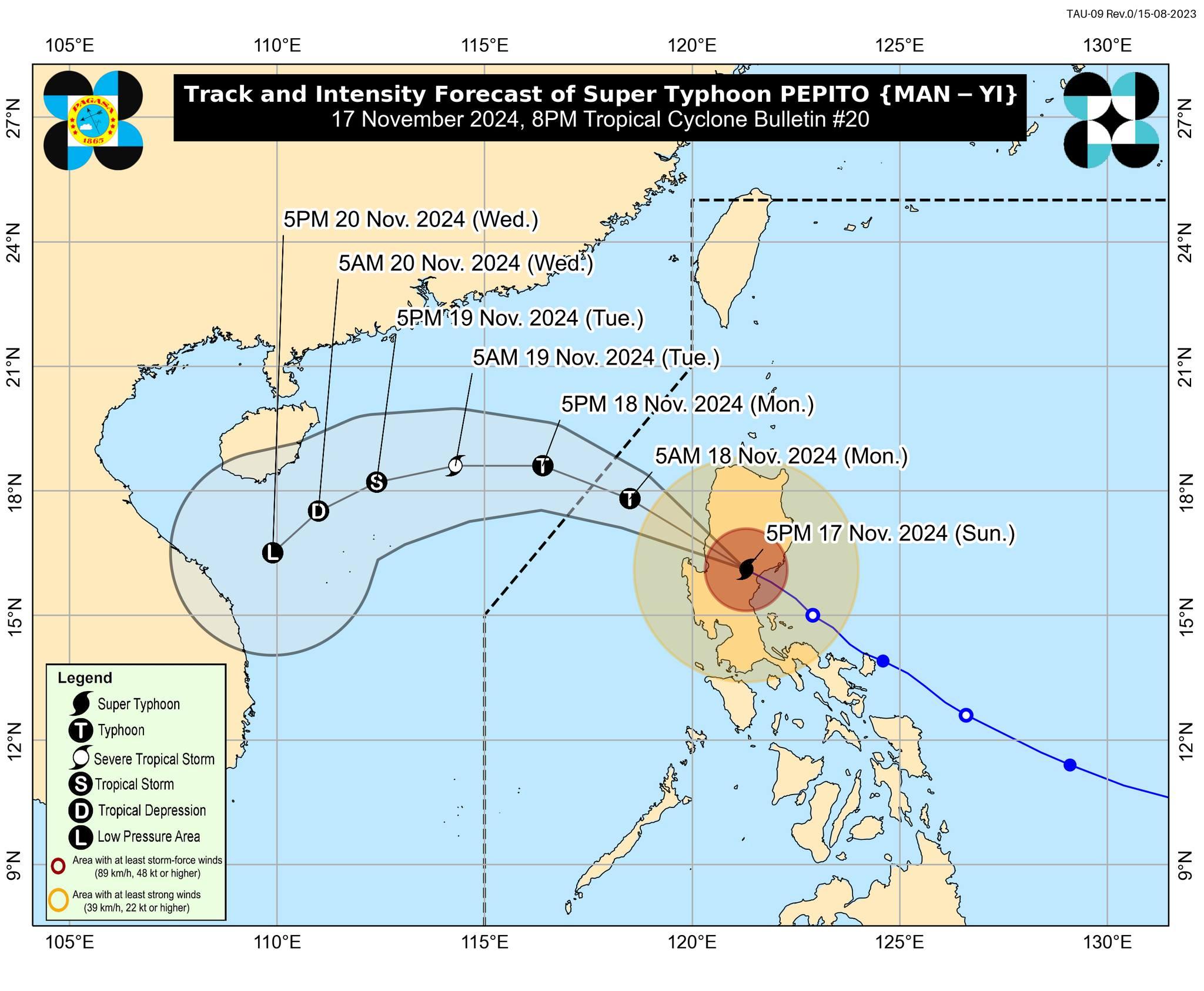
Tropical Cyclone Pepito is now over Nueva Vizcaya and has weakened into a typhoon from a super typhoon, PAGASA said Sunday evening.
According to the state weather bureau's 8 p.m. tropical cyclone bulletin, Pepito has maximum sustained winds of 165 kph near the center and gustiness of up to 275 kph, and moving west northwestward at 25 kph.
The following areas under Signal No. 4 are expected to experience winds of greater than 118 kph up to 184 kph in at least 12 hours, which may cause very heavy damage to high–risk structures:
- The central portion of Aurora (Dinalungan, Dipaculao, Baler, Maria Aurora)
- Quirino
- Nueva Vizcaya
- the southern portion of Ifugao (Kiangan, Lamut, Tinoc, Asipulo, Lagawe)
- Benguet
- the southern portion of Ilocos Sur (Alilem, Sugpon, Suyo, Santa Cruz, Tagudin, City of Candon, Santa Lucia, Salcedo, Galimuyod, Cervantes, Sigay)
- La Union
- the northern and eastern portions of Pangasinan (Sison, Tayug, Binalonan, San Manuel, Asingan, San Quintin, Santa Maria, Natividad, San Nicolas, Balungao, Pozorrubio, Laoac, San Jacinto, San Fabian, Manaoag, City of Urdaneta, Rosales, Umingan, Mangaldan, Mapandan, Villasis, Santo Tomas, Dagupan City, Anda, Bolinao, Bani, City of Alaminos, Lingayen, Binmaley, Sual, Labrador)
- the northern portion of Nueva Ecija (Bongabon, Pantabangan, Rizal, Lupao, San Jose City, Carranglan, Science City of Muñoz, Talugtug, Cuyapo, Llanera)
Signal No. 3 was raised over the following areas:
- The southern portion of Isabela (San Agustin, Jones, Echague, San Guillermo, Angadanan, Alicia, San Mateo, Ramon, San Isidro, City of Santiago, Cordon, Dinapigue, Roxas, Aurora, Cabatuan, City of Cauayan, Luna, San Mariano, Benito Soliven, Naguilian, Reina Mercedes, San Manuel, Burgos), the rest of Ifugao, Mountain Province, the southern portion of Kalinga (Pasil, Tanudan, Lubuagan, Tinglayan)
- the southern portion of Abra (Tubo, Luba, Pilar, Villaviciosa, San Isidro, Pidigan, Langiden, San Quintin, Bangued, Manabo, Boliney, Peñarrubia, Bucloc, Sallapadan, Bucay)
- the rest of Ilocos Sur
- the rest of Pangasinan
- the northern and eastern portions of Tarlac (Paniqui, La Paz, Moncada, City of Tarlac, Gerona, Pura, San Clemente, Santa Ignacia, Victoria, Camiling, Concepcion, Ramos, San Manuel, Anao)
- the rest of Nueva Ecija
- the rest of Aurora
Signal No. 2 was hoisted over the following areas:
- The rest of Isabela
- the southwestern portion of mainland Cagayan (Enrile, Tuao, Solana, Tuguegarao City, Piat, Rizal)
- the rest of Kalinga
- the southern portion of Apayao (Conner, Kabugao)
- the rest of Abra
- Ilocos Norte
- Zambales
- the rest of Tarlac
- the northern portion of Bataan (Orani, Abucay, Hermosa, Samal, Dinalupihan)
- Pampanga
- Bulacan
- Metro Manila
- Rizal
- the northeastern portion of Laguna (Kalayaan, Paete, Pangil, Pakil, Siniloan, Famy, Santa Maria, Mabitac)
- the northern portion of Quezon (General Nakar, Infanta, Real) including Polillo Islands
Signal No. 1 is up in the following areas:
- The rest of mainland Cagayan
- the rest of Apayao
- the rest of Bataan
- Cavite
- the rest of Laguna
- Batangas
- the central portion of Quezon (Calauag, Pitogo, Lucena City, Pagbilao, Tiaong, Lopez, Guinayangan, Unisan, Plaridel, Quezon, San Antonio, Alabat, Candelaria, Lucban, Sampaloc, Padre Burgos, Sariaya, City of Tayabas, Macalelon, Mauban, Dolores, Perez, Agdangan, Gumaca, Atimonan, Tagkawayan)
- Lubang Islands
- the western portion of Camarines Norte (Santa Elena, Paracale, Labo, Vinzons, Jose Panganiban, Capalonga)
Storm surge, gale warning
PAGASA said a Gale Warning is hoisted over the eastern seaboard of Luzon and the western seaboards of northern and central Luzon.
A high risk of life-threatening storm surge with peak surge heights exceeding 3.0 meters may also occur in the next 48 hours in the low-lying or exposed coastal localities of Ilocos Region, southeastern mainland Cagayan, Isabela, Central Luzon, Metro Manila, Cavite, and Quezon (eastern coast) including Polillo Islands.
Track
PAGASA said Pepito is forecast to exit the landmass of Luzon through Pangasinan, La Union, or southern Ilocos Sur on Sunday evening or early Monday morning.
“During this period, Pepito will significantly weaken due to land interaction but will likely emerge over the West Philippine Sea as a typhoon,” the state weather bureau said.
“Over the West Philippine Sea, PEPITO will continue moving generally west northwestward tomorrow,” it added.
Pepito is seen to exit the Philippine Area of Responsibility on Monday morning or noon.
Walang Pasok, other effects
Several provinces, cities and municipalities across Luzon have declared the suspension of classes on Monday due to Pepito, as well as the suspension of work in government offices except for those involved in health, disaster relief, and other vital services.
Some areas in provinces hard hit by the typhoon have lost power, while some military units are on red alert, ready to render assistance to communities. In San Andres, Catanduanes, police helped a woman deliver a baby boy amid the storm. — Mariel Celine Serquiña/BM, GMA Integrated News


