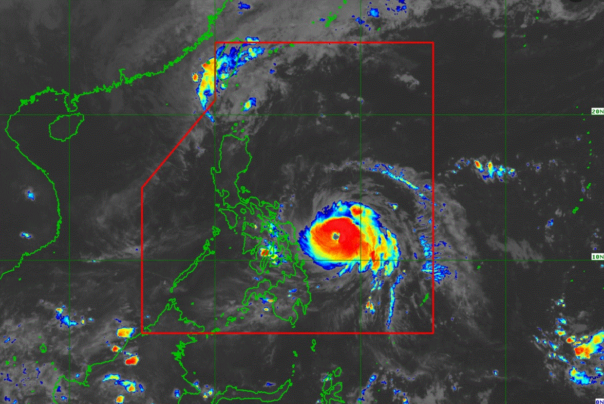
Signal No. 2 up over 7 areas due to Pepito; Ofel re-enters PAR

More areas have been placed under Signal No. 2 as Typhoon Pepito continues to intensify over the Philippine Sea.
According to PAGASA’s 11 p.m. cyclone bulletin, Pepito was last seen 305 kilometers east of Guiuan, Eastern Samar with maximum sustained winds of 155 km/h and gustiness of up to 190 km//h.
The following three areas under Signal No. 2 may have winds of 62 km/h up to 88 kn/h in at least 24 hours:
- the northern and eastern portions of Camarines Sur (Caramoan, Siruma, Tinambac, Lagonoy, Garchitorena, Presentacion, San Jose, Goa, Sagñay, Tigaon)
- Catanduanes
- the eastern portion of Albay (Bacacay, City of Tabaco, Rapu-Rapu, Malilipot, Santo Domingo, Malinao, Tiwi, Manito)
- the eastern portion of Sorsogon (City of Sorsogon, Gubat, Prieto Diaz, Barcelona, Casiguran, Bulusan)
- the northern and eastern portions of Northern Samar (Mapanas, Gamay, Palapag, Lapinig, Silvino Lobos, Laoang, Catubig, Las Navas, Pambujan, Mondragon, San Roque, Catarman, Lope de Vega, Biri, San Jose, Bobon, Rosario, Lavezares)
- the northern portion of Eastern Samar (Arteche, Oras, San Policarpo, Dolores, Jipapad, Maslog, Can-Avid, Taft)
- the northeastern portion of Samar (San Jose de Buan, Matuguinao)
The following areas under Signal No. 1 may experience winds of 39 km/h to 61 km/h or intermittent rains within the next 36 hours:
- the southern and eastern portions of Isabela (Dinapigue, Palanan, San Mariano, San Guillermo, Jones, Echague, San Agustin, Angadanan, Benito Soliven, City of Cauayan, City of Santiago, San Isidro, Alicia, Naguilian)
- Quirino
- the eastern and southern portions of Nueva Vizcaya (Alfonso Castañeda, Kasibu, Dupax del Norte, Dupax del Sur)
- Aurora
- the eastern portion of Nueva Ecija (Pantabangan, Rizal, Bongabon, General Mamerto Natividad, Palayan City, General Tinio, Gabaldon, Laur, Peñaranda, Cabanatuan City, Santa Rosa, San Leonardo, City of Gapan)
- the eastern portion of Bulacan (Doña Remedios Trinidad, San Miguel, Norzagaray, City of San Jose del Monte, San Ildefonso, San Rafael, Baliuag, Bustos, Santa Maria, Bocaue, Marilao, City of Meycauayan, Obando, Balagtas, Angat, Pandi)
- Metro Manila
- Laguna
- Rizal
- Quezon
- Marinduque
- Camarines Norte
- the rest of Camarines Sur
- the rest of Albay
- the rest of Sorsogon
- Masbate including Burias and Ticao Islands
- the rest of Northern Samar
- the rest of Eastern Samar
- the rest of Samar
- Biliran
- the northeastern portion of Leyte (Barugo, San Miguel, Babatngon, Tacloban City)
“It must be emphasized that heavy rainfall, severe winds, and storm surge may still be experienced in localities outside the landfall point and the forecast confidence cone,” PAGASA noted in its advisory.
Pepito might make a landfall near Catanduanes on Saturday evening or Sunday morning as it rapidly intensifies within Friday night and reach Super Typhoon Category prior to landfall.
“Considering the limits of the forecast confidence cone, a landfall scenario over the eastern coast of Camarines Sur, Albay, or Sorsogon during the same time frame, over the eastern coast of Northern Samar [Saturday] afternoon or evening, or along the eastern coast of Quezon or Aurora on Sunday afternoon or evening remains not ruled out,” the advisory continued.
It is predicted to slightly weaken after initial passage, and will continue through the country as a Typhoon and be downgraded into a severe tropical storm by Monday.
Typhoon Pepito is expected to exit the PAR by Monday.
Ofel
Meanwhile, Tropical Storm Ofel has re-entered the Philippine Area of Responsibility as of 10 p.m. and is moving northward at 10 kph near Batanes.
Ofel was last seen at 220 kilometers west northwest of Itbayat, Batanes with maximum sustained winds of 85 kph and gustiness of up to 105 kph.
No areas of the country are under wind signals due to Ofel.
Ofel had since downgraded from a Typhoon to a Tropical Storm and may continue to weaken as it moves towards Taiwan.
It is predicted to downgrade into a remnant low by Sunday evening or earlier. —LDF, GMA Integrated News


