PAGASA: More areas under wind signals due to Pepito; Ofel re-entry possible

Wind signals have been raised in more areas as Typhoon Pepito rapidly intensifies, according to PAGASA’s 5 p.m. cyclone bulletin.
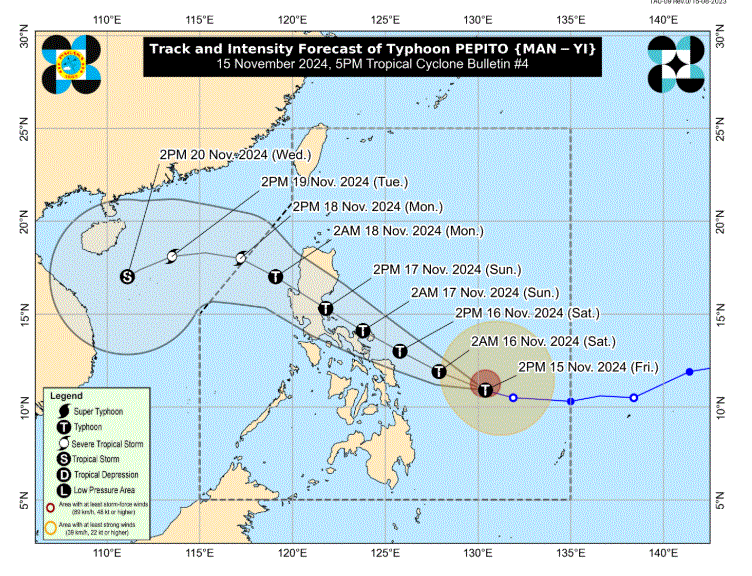
Pepito was last seen 465 kilometers east of Guiuan, Eastern Samar with maximum sustained winds of 150 km/h and gustiness of up to 185 km/h.
The following three areas under Signal No. 2 may have winds of 62 km/h up to 88 km/h in at least 24 hours:
- ·the eastern portion of Northern Samar (Mapanas, Gamay, Palapag, Lapinig, Silvino Lobos, Laoang, Catubig, Las Navas, Pambujan, Mondragon, San Roque, Catarman, Lope de Vega)
- ·the northern portion of Eastern Samar (Arteche, Oras, San Policarpo, Dolores, Jipapad, Maslog, Can-Avid)
- ·the northeastern portion of Samar (San Jose de Buan, Matuguinao)
The following areas under Signal No. 1 may experience winds of 39 km/h to 61 km/h or intermittent rains within the next 36 hours:
- Aurora
- Quezon
- the eastern portion of Laguna (Santa Maria, Famy, Siniloan, Pangil, Mabitac, Pakil, Paete, Kalayaan, Lumban, Cavinti, Luisiana, Pagsanjan, Santa Cruz, Magdalena, Majayjay, Liliw, Nagcarlan, San Pablo City, Rizal)
- Marinduque
- Camarines Norte
- Camarines Sur
- Catanduanes
- Albay
- Sorsogon
- Masbate
- the rest of Northern Samar
- the rest of Eastern Samar
- the rest of Samar
- Biliran
Over the next five days, Pepito will continue to move west northwestward and may make a landfall near Catanduanes on Saturday evening or Sunday morning.
“Considering the limits of the forecast confidence cone, a landfall scenario over the eastern coast of Camarines Sur, Albay, or Sorsogon during the same time frame, over the eastern coast of Northern Samar [Saturday] afternoon or evening, or along the eastern coast of Quezon or Aurora on Sunday afternoon or evening remains not ruled out,” read the advisory.
“It must be emphasized that heavy rainfall, severe winds, and storm surge may still be experienced in localities outside the landfall point and the forecast confidence cone,” it added.
Typhoon Pepito is predicted to rapidly intensify until Saturday, and may reach Super Typhoon category prior to landfall on Saturday evening or Sunday morning.
It will enter a weakening trend and may pass through the Philippines as a typhoon for the rest of the forecast period, and pass through the West Philippine Sea on Monday as a Severe Tropical Storm.
Ofel re-entry possible
Itbayat, Batanes remains under Signal No. 1 as Severe Tropical Storm Ofel hovers outside the Philippine Area of Responsibility (PAR).
Ofel was last seen 205 kilometers west northwest of Itbayat, Batanes with maximum sustained winds of 100 km/h and gustiness of up to 125 km/h.
PAGASA does not remove the possibility of PAR re-entry within Friday night.
Tropical cyclone wind signals may still be raised over extreme northern Luzon during its time outside PAR.
Ofel may possibly make landfall over the southwestern coast of Taiwan by Saturday morning or afternoon.
It will continue to weaken and may be downgraded into a remnant low by Sunday evening or Monday morning. —LDF, GMA Integrated News


