Pepito undergoes 'rapid intensification' as Signal No. 2 up over 2 Visayas areas

Tropical Cyclone Wind Signal No. 2 is raised over two areas in the Visayas as Typhoon Pepito "rapidly intensified" on Friday morning, according to state weather bureau PAGASA.
In its 11 a.m. bulletin, PAGASA raised the following storm warnings:
Signal No. 2
- The eastern portion of Northern Samar (Mapanas, Gamay, Palapag, Lapinig)
- The northern portion of Eastern Samar (Arteche, Oras, San Policarpo, Dolores, Jipapad, Maslog)
Signal No. 1
Luzon
- Rhe southeastern portion of Quezon
- Camarines Norte
- Camarines Sur
- Catanduanes
- Albay
- Sorsogon
- Masbate
Visayas
- The rest of Northern Samar
- The rest of Eastern Samar
- Samar
- Biliran
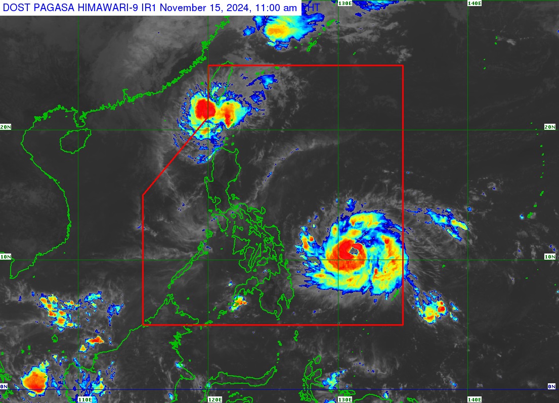
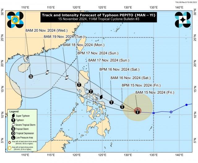
Pepito was last spotted 630 kilometers east of Guiuan, Eastern Samar moving westward at 30 kilometers per hour (kph) with maximum sustained winds of 130 kph near the center and gustiness of up to 160 kph.
“PEPITO is more likely to make landfall in the vicinity of Catanduanes tomorrow (16 November) evening or on Sunday (17 November) early morning,” PAGASA said.
“However, considering the limits of the forecast confidence cone, a landfall scenario over the eastern coast of Camarines Sur, Albay, or Sorsogon during the same time frame, over the eastern coast of Northern Samar tomorrow afternoon or evening, or along the eastern coast of Quezon or Aurora on Sunday afternoon or evening remains not ruled out,” PAGASA said.
Pepito is expected to move generally west northwestward over the weekend and pass over or near the landmass of Bicol, Quezon, Central Luzon provinces, and Pangasinan.
LIVE BLOG: Ofel and Pepito updates

According to PAGASA, Pepitpo may reach the super typhoon category.
“PEPITO will continue to rapidly intensify today through tomorrow and may reach super typhoon category prior to its landfall tomorrow evening or on Sunday early morning,” PAGASA said.
“Although a slight weakening may occur after its initial passage over land, much of the weakening will occur on Sunday as PEPITO passes over landmass of Central Luzon. Nevertheless, it will traverse the country as a typhoon and may only be downgraded into a severe tropical storm once it is over the West Philippine Sea on Monday,” it added.
Classes and work in government offices for Friday, November 15, 2024, have been suspended in some areas due to the possible effects of Pepito.
Officials are already bracing for Pepito which could hit eastern towns and the capital region over the weekend as it continues to intensify in the western Pacific.
The Philippines is dealing with its sixth storm in a month, mainly hitting the main island of Luzon.
Tropical Storm Kristine (Trami) and Typhoon Leon (Kong-rey) brought heavy flooding and triggered landslides, killing 162 people with 22 still missing, according to government data.
Four storms churned in the western Pacific ocean at the same time this month, the first time it has happened since records began in 1951, the Japan Meteorological Agency said.
About 20 tropical storms strike the Philippines each year on average, bringing heavy rains, strong winds and deadly landslides.

Ofel
Meanwhile Tropical Cyclone Wind Signal (TCWS) No. 2 was raised over Batanes as Ofel weakened into severe tropical storm over the Luzon Strait.
Signal No. 1 is raised over the following areas in Luzon
- The northern portion of Cagayan (Pamplona, Claveria, Abulug, Sanchez-Mira, Santa Praxedes, Ballesteros)
- Babuyan Islands
- The northern portion of Apayao (Luna, Santa Marcela, Calanasan)
- The northern portion of Ilocos Norte (Pagudpud, Adams, Bangui, Dumalneg, Burgos, Pasuquin, Vintar, Bacarra, Piddig, Carasi)
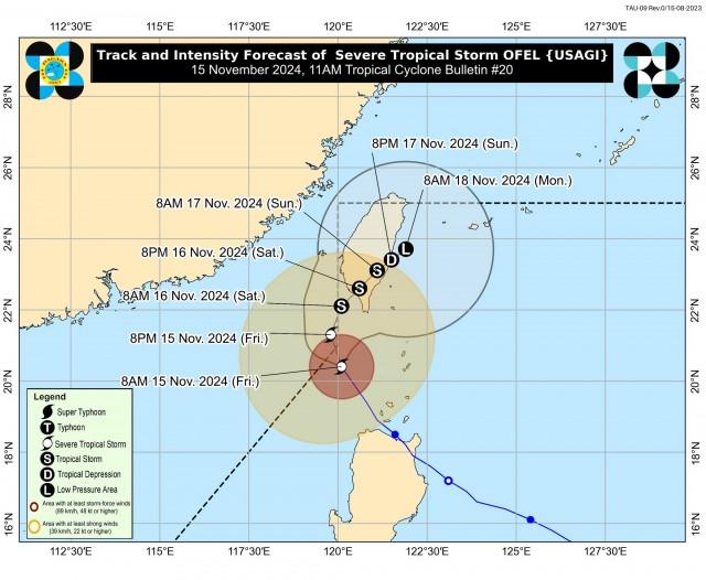
Ofel was last spotted located 215 kilometers northwest of Calayan, Cagayan or 195 kilometers west of Itbayat, Batanes moving north northwestward at 20 kilometers per hour (kph).
The severe tropical storm was packing maximum sustained winds of 110 kph near the center and gustiness of up to 135 kph.
PAGASA said Ofel may exit the Philippine area of responsibility (PAR) on Friday afternoon but may re-enter.
“OFEL will continue to move north northwestward and may briefly exit the northwestern boundary of PAR this afternoon. Outside PAR, the tropical cyclone will then move generally northward until tomorrow (16 November) early morning over the sea west of Batanes,” it said.
“OFEL may then re-enter the PAR region as it turns generally northeastward towards southern Taiwan and will remain inside PAR until the rest of the forecast period,” it added.
—with Reuters/ VAL, GMA Integrated News


