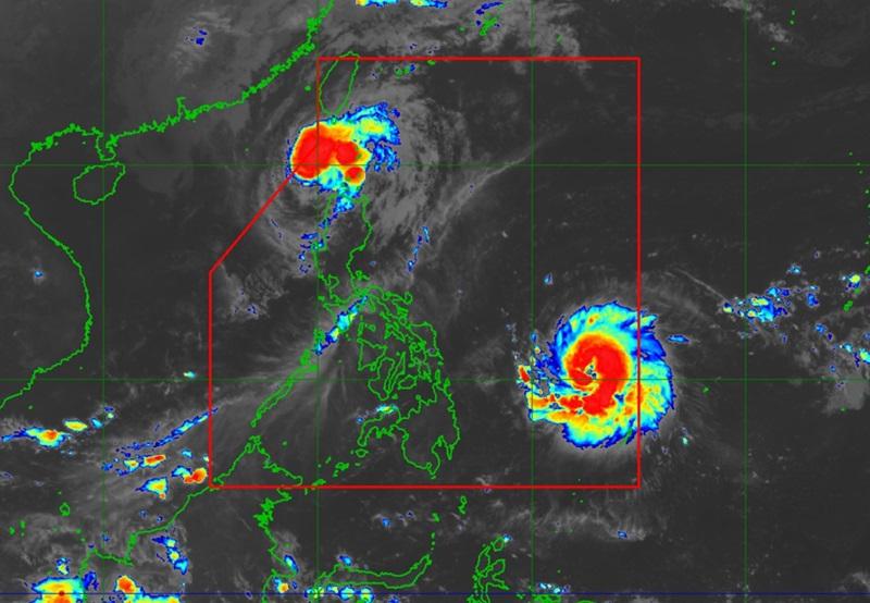
Pepito further intensifies; Ofel continues to weaken over Luzon Strait

Severe Tropical Storm Pepito further intensified and is now nearing Typhoon category while Typhoon Ofel continues to weaken over Luzon Strait, PAGASA said in its 5 a.m. Tropical Cyclone Bulletin.
As of 4 a.m., the center of Severe Tropical Storm Pepito was estimated at 795 kilometers east of Guiuan, Eastern Samar packing maximum sustained winds of 110 kilometers per hour near the center, gustiness of up to 135 kph, central pressure of 980 hPa and moving westward at 25 kph with strong to storm-force winds that extend outwards up to 380 km from the center.
Tropical Cyclone Wind Signal (TCWS) No. 1 is hoisted over the following areas:
Luzon
- Catanduanes
- the eastern portion of Camarines Norte (Vinzons, Talisay, Daet, Mercedes, Basud)
- the eastern portion of Camarines Sur (Caramoan, Garchitorena, Presentacion, San Jose, Lagonoy, Tinambac, Goa, Siruma,Tigaon, Sagñay, Calabanga, Naga City, Magarao, Bombon, Pili, Ocampo, Iriga City, Buhi)
- the eastern portion of Albay (Rapu-Rapu, City of Tabaco, Malilipot, Santo Domingo, Bacacay, Legazpi City, Malinao, Manito, Tiwi)
- the eastern and southern portions of Sorsogon (Juban, City of Sorsogon, Barcelona, Bulusan, Magallanes, Gubat, Santa Magdalena, Casiguran, Bulan, Irosin, Matnog, Prieto Diaz, Castilla)
Visayas
- Northern Samar
- the northern portion of Eastern Samar (San Policarpo, Arteche, Jipapad, Maslog, Oras, Dolores, Can-Avid)
- the northeastern portion of Samar (Matuguinao, San Jose de Buan)
Typhoon Ofel
As of 4 a.m., the center of Typhoon Ofel was estimated at 100 kilometers northwest of Calayan, Cagayan packing maximum sustained winds of 120 kilometers per hour near the center, gustiness of up to 150 kph, central pressure of 975 hPa, and moving north northwestward at 20 kph with strong to typhoon-force winds extend outwards up to 340 km from the center
TCWS No. 3 is hoisted over the following areas:
- the western portion of Babuyan Islands (Calayan, Is., Dalupiri Is., Fuga Is.)
- the northwesternmost portion of mainland Cagayan (Claveria, Santa Praxedes)
- the northernmost portion of Ilocos Norte (Pagudpud)
TCWS No.2 is hoisted over the following areas:
- the rest of Babuyan Island
- the northwestern portion of mainland Cagayan (Sanchez-Mira, Pamplona, Abulug, Ballesteros)
- the northern portion of Apayao (Calanasan, Luna, Santa Marcela)
- the northern portion of Ilocos Norte (Piddig, Bacarra, Adams, Dumalneg, Vintar, Bangui, Burgos, Pasuquin, Carasi)
TCWS No.1 is hoisted over the following areas:
- Batanes
- the rest of Cagayan
- the northern portion of Isabela (Quezon, Cabagan, Santa Maria, San Pablo, Maconacon, Santo Tomas, Delfin Albano, Tumauini)
- the rest of Apayao
- Kalinga
- the northern and central portions of Abra (Manabo, Pidigan, Tayum, Langiden, Boliney, Sallapadan, Bucloc, La Paz, Peñarrubia, Dolores, Bangued, Bucay, Daguioman, Lacub, Tineg, Lagayan, Licuan-Baay, Malibcong, San Juan, Lagangilang, Danglas)
- the rest of Ilocos Norte
- the northern portion of Ilocos Sur (Sinait, Cabugao, San Juan, San Ildefonso, Magsingal, Santo Domingo, Bantay, San Vicente)
Heavy Rainfall Outlook
Severe Tropical Storm Pepito is currently not directly affecting any part of the country.
Heavy rainfall outlook due to Tropical Cyclones Ofel and Pepito:
Moderate to Heavy (50-100 mm): Cagayan, Batanes, and Ilocos Norte
Severe Winds
There will be moderate to significant impacts from storm-force winds are possible within any of the areas under Wind Signal No 3, minor to moderate impacts from gale-force winds are possible within any of the areas under Wind Signal No. 2 and minimal to minor impacts from strong winds are possible within any of the areas under Wind Signal No. 1.
Coastal Inundation
There is a moderate to high risk of life-threatening storm surge reaching 2.0 to 3.0 m above normal tide levels in the next 48 hours over the low-lying or exposed coastal localities Camarines Sur, Catanduanes, Albay, Sorsogon, Northern Samar, Eastern Samar, and Samar.
Hazards affecting coastal waters
Currently, there is no gale warning raised associated with Pepito. However, a Gale Warning is hoisted over the northern and eastern seaboards of Northern Luzon due to the occurrence of Ofel.
Mariners are advised to take precautionary measures while venturing out to sea and, if possible, avoid navigation under these conditions.
Track and Intensity Outlook
Due to the high pressure area over the south of Japan, Pepito is forecast to move westward over the next 12 hours before turning west northwestward to northwestward over the Philippine Sea and may make landfall over the eastern coast of Central and/or Southern Luzon during the weekend.
Pepito may exit the Philippine Area of Responsibility on Monday afternoon or evening.
Ofel, on the other hand, will continue to move north northwestward and may exit the northwestern boundary of PAR by Friday afternoon.
Outside PAR, Ofel will then move generally northward until tomorrow Saturday morning over the sea west of Batanes but may re-enter the PAR as it turns generally northeastward towards southern Taiwan and will remain inside PAR until the rest of the forecast period. — BAP, GMA Integrated News


