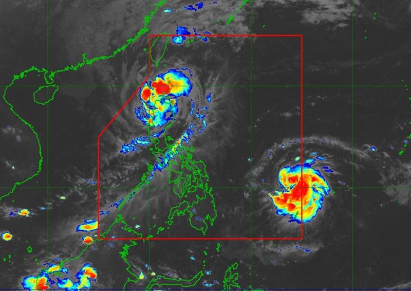
Signal No. 4 over three Luzon areas due to Ofel, may exit PAR soon

Typhoon Ofel passed closely between Babuyan Islands and the northern portion of mainland Cagayan with three areas under Signal No. 4 but forecast to exit the Philippine Area of Responsibility (PAR) by Friday afternoon, according to the Tropical Cyclone Bulletin posted by PAGASA.
As of 1 a.m., the center of Typhoon Ofel was estimated to be over the coastal waters of Calayan, Cagayan packing maximum sustained winds of 130 kilometers per hour near the center, gustiness of up to 180 kph, and central pressure of 970 hPa.
Ofel is moving northwestward at the speed of 25 kph with strong to typhoon-force winds extend outwards up to 340 km from the center.
Tropical Cyclone Wind Signal (TCWS) No. 4 is hoisted over the following areas:
- the western portion of Babuyan Islands (Calayan Is., Dalupiri Is., Fuga Is.)
- the northwestern portion of Cagayan (Abulug, Pamplona, Sanchez-Mira, Claveria, Santa Praxedes, Ballesteros)
- the northernmost portion of Ilocos Norte (Pagudpud)
TCWS No.3 is hoisted over the following areas:
- the northern and central portions of mainland Cagayan (Lasam, Alcala, Amulung, Santo Niño, Rizal, Piat, Gattaran, Gonzaga, Santa Ana, Santa Teresita, Lal-Lo, Buguey, Allacapan, Camalaniugan, Baggao, Aparri)
- the northern and central portions of Apayao (Flora, Pudtol, Kabugao, Calanasan, Luna, Santa Marcela),
- the northern portion of Ilocos Norte (Adams, Dumalneg, Bangui, Pasuquin, Burgos, Vintar, Carasi)
TCWS No.2 is raised over the following areas:
- Batanes
- the rest of Cagayan
- the rest of Apayao
- the northern portion of Kalinga (Pinukpuk, Rizal, City of Tabuk, Balbalan)
- the northern portion of Abra (Tineg, Lacub, Malibcong, Lagayan, San Juan, Lagangilang, Licuan-Baay)
- the rest of Ilocos Norte
TCWS No.1 is raised over the following areas:
- the northern and central portions of Isabela (Santo Tomas, Alicia, San Mateo, Aurora, Santa Maria, Quezon, San Mariano, Ramon, Naguilian, Dinapigue, Roxas, San Guillermo, Luna, Delfin Albano, City of Cauayan, Echague, San Pablo, Ilagan City, Angadanan, Benito Soliven, City of Santiago, Tumauini, Cabagan, Reina Mercedes, San Manuel, Palanan, Cabatuan, Quirino, Divilacan, Gamu, San Isidro, Mallig, Cordon, Maconacon, Burgos)
- the rest of Abra
- the rest of Kalinga
- the northern and eastern portions of Mountain Province (Besao, Sagada, Sadanga, Bontoc, Natonin, Barlig, Paracelis)
- the northeastern portion of Ifugao (Aguinaldo, Alfonso Lista)
- the northern and central portions of Ilocos Sur (Sinait, Cabugao, San Juan, San Ildefonso, Magsingal, Santo Domingo, Bantay, San Vicente, City of Vigan, Caoayan, Santa Catalina, Santa, Nagbukel, Narvacan, Gregorio del Pilar, San Esteban, Banayoyo, Burgos, City of Candon, Santa Lucia, Santiago, Lidlidda, Sigay, Galimuyod, Quirino, San Emilio, Santa Maria, Salcedo)
Heavy Rainfall Outlook
Heavy rainfall outlook due to Tropical Cyclone Ofel and Pepito:
Heavy to Intense (100-200 mm): Cagayan
Moderate to Heavy (50-100 mm): Batanes, Ilocos Norte, Apayao, and Abra
Severe Winds
There will be significant to severe impacts from typhoon-force winds are possible within any of the areas under Wind Signal No. 4, moderate to significant impacts from storm-force winds are possible within any of the areas under Wind Signal No 3, minor to moderate impacts from gale-force winds are possible within any of thCoastal Inundatione areas under Wind Signal No. 2 and minimal to minor impacts from strong winds are possible within any of the areas under Wind Signal No. 1.
"There is a high risk of life-threatening storm surge with peak heights exceeding 3.0 m in the next 48 hours over the low-lying or exposed coastal localities of Batanes, Ilocos Norte, Ilocos Sur, Cagayan including Babuyan Islands, Isabela, and northern Aurora," PAGASA reported.
Hazards over coastal waters
A Gale Warning is hoisted over the northern and eastern seaboards of Northern Luzon.
PAGASA warned that mariners should take precautionary measures while venturing out to sea and, if possible, avoid navigation under these conditions.
Track and Intensity Outlook
The weather bureau reported that Typhoon will continue moving northwestward and may exit the northwestern boundary of PAR this afternoon then move generally northward until Saturday morning over the sea west of Batanes.
However, Ofel may then re-enter the PAR region as it turns generally northeastward towards Taiwan and will remain inside PAR until the rest of the weekend. — BAP, GMA Integrated News


