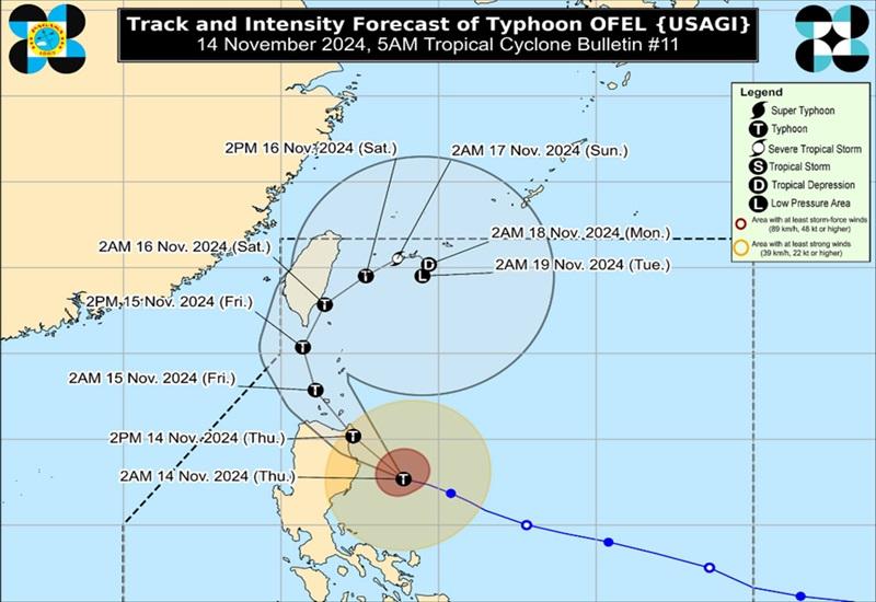
Ofel further intensifies; Signal No. 4 raised over northeast Cagayan

Typhoon Ofel further intensified as it neared super typhoon category, prompting state weather bureau PAGASA to raise Tropical Cyclone Wind Signal No. 4 over the northeastern portion of Cagayan early Thursday morning.
In its 5 a.m. bulletin, PAGASA said that as of 10 p.m. on Wednesday, the center of the eye of Typhoon Ofel was estimated at 215 kilometers east of Echague, Isabela packing maximum sustained winds of 165 kilometers per hour near the center, gustiness of up to 205 km/h, and central pressure of 950 hPa.
Ofel is moving west northwestward at the speed of 30 kph with strong to typhoon-force winds extend outwards up to 320 km from the center.
Tropical Cyclone Wind Signal (TCWS) No. 4 is raised over the northeastern portion of mainland Cagayan (Santa Ana, Gonzaga, Santa Teresita)
TCWS No. 3 is raised over the following areas:
- the northwestern, central, and eastern portions of mainland Cagayan (Claveria, Sanchez-Mira, Santa Praxedes, Pamplona, Abulug, Ballesteros, Aparri, Camalaniugan, Lal-Lo, Allacapan, Gattaran, Baggao, Peñablanca, Lasam, Alcala, Amulung, Iguig, Santo Niño, Buguey) including Babuyan Islands
- the northeastern portion of Isabela (Maconacon, San Pablo, Divilacan, Palanan)
- the northern portion of Apayao (Flora, Santa Marcela, Luna, Pudtol, Calanasan)
TCWS No. 2 is raised over thw following areas:
- Batanes
- the rest of Cagayan
- the northwestern and southeastern portions of Isabela (Cabagan, Santa Maria, Santo Tomas, Tumauini, Ilagan City, Delfin Albano, Quezon, San Mariano, Dinapigue, Quirino, Mallig)
- the rest of Apayao
- the northern portion of Kalinga (Pinukpuk, Rizal, City of Tabuk, Balbalan)
- the northeastern portion of Abra (Tineg, Lacub, Malibcong)
- the northern and central portions of Ilocos Norte (Carasi, Vintar, Burgos, Adams, Pagudpud, Bangui, Dumalneg, Pasuquin, Bacarra, Piddig, Nueva Era, Solsona, Dingras, Marcos, Banna, Sarrat, Laoag City, San Nicolas, City of Batac, Paoay)
TCWS No. 1 is raised over the following areas:
- the rest of Isabela
- Quirino
- Nueva Vizcaya
- the rest of Abra
- the rest of Kalinga
- Mountain Province
- Ifugao
- the northern portion of Benguet (Bokod, Mankayan, Kapangan, Atok, Kabayan, Kibungan, Bakun, Buguias, Tublay)
- the rest of Ilocos Norte
- Ilocos Sur
- the northern portion of La Union (Luna, Sudipen, Bangar, Santol, San Gabriel, Bagulin, Bacnotan, Balaoan, San Juan)
- the northern and central portions of Aurora (Dilasag, Casiguran, Dinalungan, Dipaculao, Maria Aurora, Baler, San Luis)
Heavy Rainfall Outlook
Heavy rainfall outlook due to Tropical Cyclone Ofel:
Intense to Torrential (>200 mm): Cagayan and Isabela
Heavy to Intense (100-200 mm): Batanes, Ilocos Norte, Apayao, and Kalinga
Moderate to Heavy (50-100 mm): Abra, Mountain Province, Ifugao, Quirino, Nueva Vizcaya, and Aurora
Severe Winds
There will be ignificant to severe impacts from typhoon-force winds are possible within any of the areas under Wind Signal No. 4, moderate to significant impacts from gale-force winds are possible within any of the areas under Wind Signal No. 3, minor to moderate impacts from strong winds are possible within any of the areas under Wind Signal No. 2 and minimal to minor impacts from strong winds are possible within any of the areas under Wind Signal No. 1.
Coastal Inundation
PAGASA said there is a moderate to high risk of life-threatening storm surge with peak heights reaching 1.0 to 3.0 m in the next 48 hours over the low-lying or exposed coastal localities of Batanes, Ilocos Norte, Ilocos Sur, Cagayan including Babuyan Islands, Isabela, and northern Aurora.
Hazards affecting coastal waters
A Gale Warning is hoisted over the northern and eastern seaboards of Northern Luzon and the eastern seaboard of Central Luzon.
Mariners of motorbancas and similarly-sized vessels are advised to take precautionary measures while venturing out to sea and, if possible, avoid navigation under these conditions.
Track and Intensity Outlook
Typhoon Ofel is forecast by PAGASA to move northwestward over the Philippine Sea before making landfall along the eastern coast of Cagayan or northern Isabela this afternoon and will then emerge over Babuyan Channel tonight while making another landfall or passing close to Babuyan Islands.
Ofel will then turn north northwestward to north northeastward over the sea west of Batanes by Friday before turning northeastward beginning Saturday over the sea east of Taiwan towards Ryukyu Islands by the remaining forecast period. — BAP, GMA Integrated News


