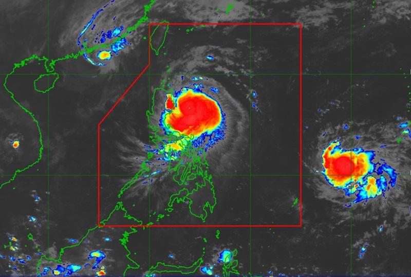
Ofel maintains strength, Signal No. 3 over two areas

Typhoon Ofel continues to move in the west northwest direction over the sea east of Isabela as Signal No. 3 remains over two areas, according to the latest Tropical Cyclone Bulletin posted by PAGASA.
As of 1 a.m., the center of the eye of Typhoon Ofel was estimated at 225 kilometers east of Casiguran, Aurora or 265 km East of Echague, Isabela packing maximum sustained winds of 150 kilometers per hour near the center, gustiness of up to 185 kph, and central pressure of 960 hPa.
Ofel is moving west northwestward at the speed of 25 kph with strong to typhoon-force winds extend outwards up to 320 km from the center.
Tropical Cyclone Wind Signal (TCWS) No. 3 is hoisted over the following areas:
- the northeastern portion of mainland Cagayan (Santa Ana, Gonzaga)
- the southeastern portion of Babuyan Islands (Camiguin Is.)
TCWS No. 2 is hoisted over the following areas:
- the southern portion of Batanes (Mahatao, Uyugan, Basco, Ivana, Sabtang)
- the rest of Babuyan Islands
- the rest of mainland Cagayan
- the northern and eastern portions of Isabela (Maconacon, Divilacan, Palanan, San Pablo, Cabagan, Santa Maria, Santo Tomas, Tumauini, Ilagan City)
- Apayao
- the northern portion of Ilocos Norte (Carasi, Vintar, Burgos, Adams, Pagudpud, Bangui, Dumalneg)
TCWS No. 1 is hoisted over the following areas:
- the rest of Batanes
- the rest of Isabela
- Quirino
- the northern portion of Nueva Vizcaya (Kasibu, Ambaguio, Solano, Bayombong, Quezon, Bagabag, Diadi, Villaverde)
- Kalinga
- Abra
- Mountain Province
- Ifugao
- the rest of Ilocos Norte
- the northern portion of Ilocos Sur (Sinait, Cabugao, San Juan, San Ildefonso, Magsingal, Santo Domingo, Bantay, San Vicente, City of Vigan, Caoayan, Santa Catalina, Santa, Nagbukel, Narvacan)
- the northern portion of Aurora (Dilasag, Casiguran, Dinalungan, Dipaculao)
Heavy Rainfall Outlook
Heavy rainfall outlook due to Tropical Cyclone Ofel:
Intense to Torrential rainfall (>200 mm) over Cagayan and Isabela
Heavy to Intense rainfall (100-200 mm) over Apayao and Kalinga
Moderate to Heavy rainfall (50-100 mm) over Batanes, Ilocos Norte, Abra, Mountain Province, Ifugao, Quirino, Nueva Vizcaya, and Aurora
Severe Winds
There will be moderate to significant impacts from gale-force winds are possible within any of the areas under Wind Signal No. 3, minor to moderate impacts from strong winds are possible within any of the areas under Wind Signal No. 2, and minimal to minor impacts from strong winds are possible within any of the areas under Wind Signal No. 1.
Coastal Inundation
PAGASA said there is a moderate to high risk of life-threatening storm surge with peak heights reaching 1.0 to 3.0 m in the next 48 hours over the low-lying or exposed coastal localities of Batanes, Ilocos Norte, Ilocos Sur, Cagayan including Babuyan Islands, Isabela, and northern Aurora.
Hazards affecting coastal waters
A Gale Warning is hoisted over the northern and eastern seaboards of Northern Luzon and the eastern seaboard of Central Luzon.
Mariners are advised to take precautionary measures while venturing out to sea and, if possible, avoid navigation under these conditions.
Track and Intensity Outlook
Ofel is forecast to move west northwestward to northwestward over the Philippine Sea before making landfall along the eastern coast of Cagayan or Isabela by this afternoon, said PAGASA, adding that it will then emerge over Babuyan Channel tonight while making another landfall or passing close to Babuyan Islands.
"Ofel will then turn north northwestward to north northeastward over the sea west of Batanes by tomorrow noon before turning northeastward to east northeastward from Saturday over the sea east of Taiwan towards Ryukyu Islands throughout the rest of the forecast period," the weather bureau reported. — BAP, GMA Integrated News


