Signal No. 2 up over parts of Cagayan, Isabela as Ofel maintains strength

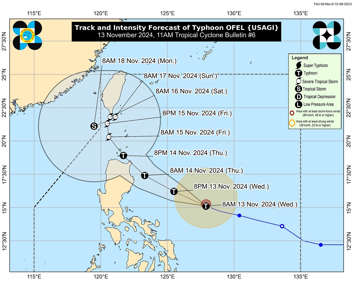
Tropical Cyclone Wind Signal (TCWS) No. 2 was raised over some parts of Cagayan and Isabela provinces as Typhoon Ofel maintained its strength over the Philippine Sea on Wednesday morning, state weather bureau PAGASA said.
In its 11 a.m. bulletin, PAGASA said the following areas were under TCWS No. 2:
- the eastern portion of mainland Cagayan (Baggao, Peñablanca, Gattaran, Gonzaga, Lal-Lo, Santa Ana)
- the eastern portion of Isabela (Maconacon, Divilacan, Palanan)
TCWS No. 1, meanwhile, was in effect over the following areas:
- Batanes
- Babuyan Islands
- the rest of mainland Cagayan
- the rest of Isabela
- Quirino
- Nueva Vizcaya
- Apayao
- Kalinga
- Abra
- Mountain Province
- the eastern portion of Ifugao (Dilasag, Casiguran)
- Ilocos Norte
- the northern portion of Aurora (Alfonso Lista, Aguinaldo, Banaue, Mayoyao, Hingyon, Hungduan)
PAGASA said the highest wind signal that may be raised due to Ofel is TCWS No. 4.
PAGASA said Ofel (international name: Usagi) was last monitored 485 kilometers east-northeast of Daet, Camarines Norte or 610 kilometers east of Infanta, Quezon moving west northwestward at 20 kilometers per hour (kph)
The typhoon was packing maximum sustained winds of 120 kph near the center and gustiness of up to 150 kph.
“OFEL is forecast to move west northwestward to northwestward over the Philippine Sea before making landfall along the eastern coast of Cagayan or Isabela tomorrow (14 November) afternoon,” PAGASA said.
“It will then emerge over the Luzon Strait on Friday (15 November) and turn more north northwestward while slowing down before behaving erratically during the weekend,” it added.
The weather bureau said Ofel is expected to “steadily intensify within 24 hours and possibly make landfall during its peak intensity.”
Storm surge
PAGASA said there is a “moderate to high risk of life-threatening storm surge” in Batanes, Ilocos Norte, Ilocos Sur, Cagayan including Babuyan Islands, Isabela, and northern Aurora.
“There is a moderate to high risk of life-threatening storm surge reaching 1.0 to 3.0 m in the next 48 hours over the low-lying or exposed coastal localities of Batanes, Ilocos Norte, Ilocos Sur, Cagayan including Babuyan Islands, Isabela, and northern Aurora,” PAGASA said.
Moderate to heavy rains are expected over Isabela, Cagayan, and Catanduanes on Wednesday, according to PAGASA.
“Localized flooding is possible mainly in areas that are urbanized, low lying, or near rivers. Landslide possible in highly susceptible areas,” PAGASA said.
Areas under TCWS No. 2 may experience minor to moderate impacts from gale-force winds, while those under TCWS No. 1 may encounter minimal to minor impacts from strong winds.
Very rough or high seas (from 6.0 to 10.0 meters) are expected over the following coastal waters:
- Up to 10.0 m: The eastern seaboard of mainland Cagayan.
- Up to 8.0 m: The seaboards of Isabela and northern Aurora
- Up to 7.0 m: The seaboard of Babuyan Islands and the remaining seaboard of mainland Cagayan
- Up to 6.0 m: The seaboard of northern Aurora
“Sea travel is risky for all types or tonnage of vessels. All mariners must remain in port or, if underway, seek shelter or safe harbor as soon as possible until winds and waves subside,” PAGASA said.
Rough seas (from 3.5 to 4.0 meters) may be encountered in the following areas:
- Up to 4.0 m: The seaboard of Batanes
- Up to 3.5 m:The northern and eastern seaboards of Catanduanes and Polillo Islands; the remaining seaboard of Aurora; the seaboard of Camarines Norte and northern Quezon; the northern seaboard of Camarines Sur.
“Mariners of small seacrafts, including all types of motorbancas, are advised not to venture out to sea under these conditions, especially if inexperienced or operating ill-equipped vessels,” PAGASA said.
Meanwhile, moderate seas (from 2.0 to 2.5 meters) may be experienced over the following coastal waters:
- Up to 2.5 m: The northern seaboard of Ilocos Norte; the eastern seaboard of mainland Quezon including the rest of Polillo Islands, Albay, and Sorsogon; northern and eastern seaboards of Northern Samar
- Up to 2.0 m: The remaining seaboard of Ilocos Region; the seaboard of Kalayaan Islands; the eastern seaboard of Camarines Sur and Eastern Samar; the remaining seaboard of Catanduanes
“Mariners of motorbancas and similarly-sized vessels are advised to take precautionary measures while venturing out to sea and, if possible, avoid navigation under these conditions,” PAGASA said.
Pepito
Meanwhile, in a separate bulletin, PAGASA said the tropical storm with international name Man-Yi is expected to enter the Philippine area of responsibility (PAR) on Thursday evening and will be named Pepito.
PAGASA said Man-Yi may intensify into severe tropical storm on Wednesday and reach the typhoon category by Thursday afternoon or evening.
The tropical cyclone could even reach the super typhoon category, it added.
Man-Yi was last spotted at 1,965 kilometers east of Eastern Visayas moving west-southwestward at 30 kilometers per hour (kph).
The tropical storm was packing maximum sustained winds of 65 kph near the center and gustiness of up to 80 kph. —KBK, GMA Integrated News


