Cagayan, portion of Isabela, Apayao under Signal No. 1 as Ofel intensifies

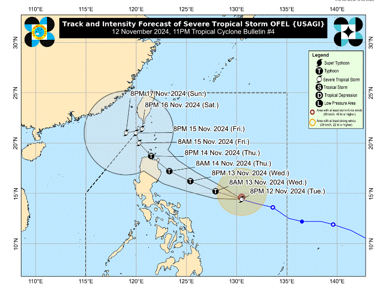
Signal No. 1 was hoisted over three areas in Luzon as Severe Tropical Storm Ofel intensified over the Philippine Sea, PAGASA said late Tuesday evening.
According to its 11 p.m. tropical cyclone bulletin, Ofel has maximum sustained winds of 110 km/h near the center and gustiness of up to 135 km/h.
The following areas under Signal No. 1 are expected to experience winds of 39-61 km/h within the next 36 hours, which may cause very light or no damage to low-risk structures:
- Cagayan including Babuyan Islands
- the northeastern portion of Isabela (Maconacon, San Pablo, Cabagan, Santa Maria, Divilacan, Palanan)
- the eastern portion of Apayao (Flora, Santa Marcela, Luna, Pudtol)
“The highest wind signal, which may be hoisted during the occurrence of Ofel, is Wind Signal No. 4,” PAGASA said.
At 10 p.m., Ofel was monitored 630 km east of Virac, Catanduanes moving west northwestward at 25 km/h.
PAGASA also warned of strong to gale-force gusts over the coastal and upland areas of Camarines Norte, Camarines Sur, and Catanduanes on Wednesday due to northeasterly wind flow.
A minimal to moderate storm surge may also occur in the next 48 hours in the low-lying or exposed coastal localities of Ilocos Norte, Cagayan including Babuyan Islands, Isabela, and northern Aurora.
PAGASA said Ofel is seen move west northwestward over the Philippine Sea before making landfall along the east coast of Cagayan or Isabela on Thursday afternoon or evening.
It will then steadily intensify in the next three days and reach typhoon category on Wednesday.
“Ofel will possibly make landfall at peak intensity,” PAGASA said.—LDF, GMA Integrated News


