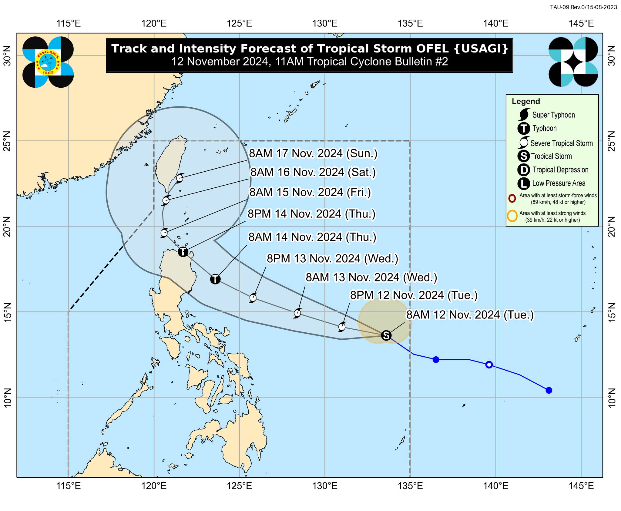
Ofel slightly intensifies as it moves over Philippine Sea

Tropical Storm Ofel slightly intensified late Tuesday morning as it moved northwestward over the Philippine Sea, state weather bureau PAGASA said.
As of 10 a.m., PAGASA said that the center of Ofel was estimated 950 kilometers east of Southeastern Luzon. It was moving northwestward at 35 km/h and has strong- to gale-force winds that extended outwards up to 230 km from the center.
It also has a maximum sustained winds of 85 km/h near the center, gustiness of up to 105 km/h, and central pressure of 996 hPa.
No wind signal is currently raised due to Ofel as of posting time, but four areas in Luzon were placed under Tropical Cyclone Wind Signal (TCWS) No. 1 due to Severe Tropical Storm Nika.
Ofel, meanwhile, is not directly affecting any part of the country, said PAGASA.
However, TCWS No. 1 may be raised over portions of Cagayan Valley on late Tuesday evening or early Wednesday morning.
The highest wind signal that may be hoisted during the occurrence of Ofel is TCWS No. 4.
The wind flow coming towards the circulation of Ofel will also bring strong- to gale-force gusts over Catanduanes on Wednesday; over Batanes, Quezon including Polillo Islands, Camarines Norte, and the northern portions of Camarines Sur and Catanduanes on Thursday; and over Isabela and the northern portion of Aurora on Friday.
Rainfall, coastal waters
PAGASA said that heavy to intense rainfall (100-200 mm) may pour over Cagayan and Isabela from Thursday noon to Friday noon due to Ofel.
Moderate to heavy rainfall (50-100 mm), meanwhile, may pour over Apayao and Kalinga.
Up to very rough or high seas (up to 4.0 meters) may also be experienced over the seaboards of Ilocos Norte and northern Ilocos Sur due to Ofel in the next 24 hours.
Up to rough seas is also expected over the following coastal waters:
- Up to 3.5 m: The seaboards of Batanes and Cagayan including Babuyan Islands
- Up to 3.0 m: The remaining seaboard of Ilocos Region, and the seaboard of northern Isabela
Meanwhile, the remaining western and eastern seaboards of Luzon, as well as the eastern seaboards of Visayas and Mindanao may have up to moderate seas (up to 2.0 meters).
Track, intensity
Ofel is seen to move west northwestward until Thursday evening before turning northwestward to northward for the rest of the forecast period. It may also make landfall over Northern or Central Luzon on Thursday afternoon or evening.
The tropical cyclone is also seen to steadily intensify in the next three days and reach typhoon category on Wednesday evening or Thursday early morning. It may reach its peak intensity prior to landfall.
“Regardless of the position of the landfall point, it must be emphasized that hazards on land and coastal waters may still be experienced in areas outside the landfall point or forecast confidence cone. It must also be emphasized that the track may still shift within the limit of the forecast confidence cone, especially on the 4th and 5th day of the forecast track,” PAGASA said.
With this, areas in Northern Luzon may be at risk of heavy rainfall, severe wind, and storm surge inundation from Ofel “which may cause considerable impacts.”
The eastern portions of Central and Southern Luzon may also be affected, especially if the tropical cyclone further expands in size or follows a more southerly path.—AOL, GMA Integrated News


