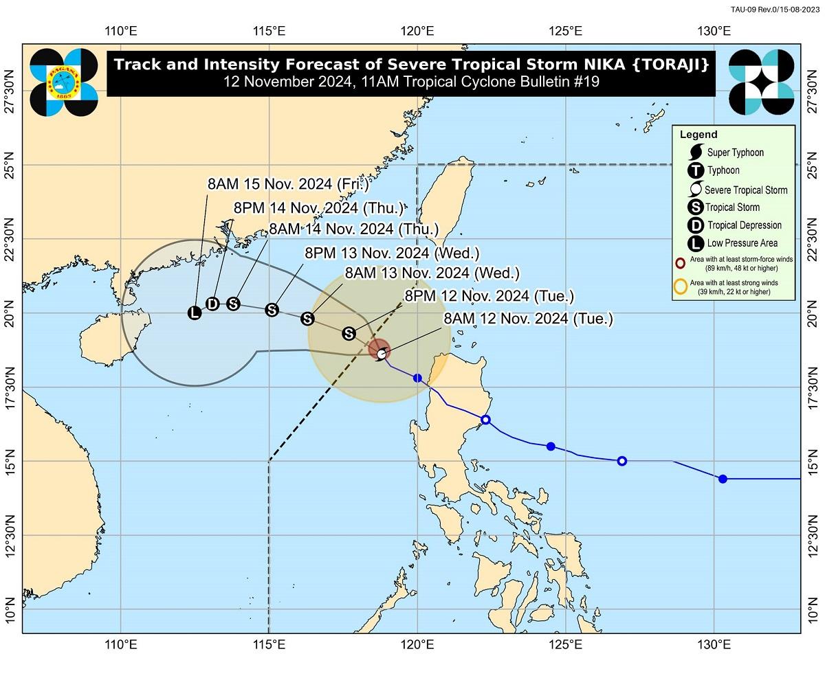
Nika about to exit PAR but Signal No. 1 raised in 4 Luzon areas

Tropical Cyclone Wind Signal (TCWS) No. 1 was raised over four areas in Luzon even as Severe Tropical Storm Nika is about to exit the Philippine area of responsibility, PAGASA said Tuesday.
As of 11 a.m., the state weather bureau said the following areas were under TCWS No.1:
- The northern portion of Ilocos Norte (Sarrat, Piddig, Bangui, Vintar, Burgos, Pagudpud, Bacarra, Adams, Pasuquin, Carasi, San Nicolas, Dumalneg, Laoag City),
- the northern portion of Apayao (Luna, Calanasan),
- the northwestern portion of Cagayan (Abulug, Pamplona, Sanchez-Mira, Santa Praxedes, Claveria),
- and the northwestern portion of Babuyan Islands (Calayan Is., Dalupiri Is., Fuga Is.)
PAGASA said strong winds from 39 to 61 km/h may be expected in these areas within the next 36 hours. Wind impacts may result in minimal to minor threat to life and property, it added.
Nika location
PAGASA said the center of Nika was last spotted at 225 kilometers west northwest of Laoag City, Ilocos Norte or 315 kilometers west of Calayan, Cagayan, packing maximum sustained winds of 95 km/h near the center, gustiness of up to 115 km/h, and central pressure of 990 hPa.
It was also moving northwestward at 10 km/h, bringing strong to storm-force winds that extend outwards up to 320 km from the center.
PAGASA said that based on the forecast track, Nika will continue moving generally northwestward to westward over the West Philippine Sea and may exit PAR Tuesday afternoon.
Nika is also seen to continue to weaken for the next few days and may become a remnant low over the sea near southern China. It will remain as a severe tropical storm throughout its passage within the PAR region.
PAGASA said that the northeasterly wind flow will also bring strong to gale-force gusts over Ilocos Sur, La Union, Pangasinan, Batanes, Cagayan including Babuyan Islands, and Isabela on Tuesday.
A gale warning is also currently hoisted over the western seaboard of Northern Luzon.
With this, up to very rough or high seas (up to 4.0 meters) may be expected over Ilocos Norte and northern Ilocos Sur.
- Up to rough seas may also be experienced over the following coastal waters:
- Up to 3.5 m: The seaboards of Batanes and Cagayan including Babuyan Islands
- Up to 3.0 m: The remaining seaboard of Ilocos Region, and the seaboard of northern Isabela
Meanwhile, the remaining western and eastern seaboards of Luzon, and the eastern seaboards of Visayas and Mindanao may have up to moderate seas (up to 2.0 meters).
Ofel
Earlier in the day, PAGASA said the tropical storm monitored east of Eastern Visayas has entered the Philippine Area of Responsibility (PAR) on Tuesday, and was assigned the domestic name Ofel (international name: Usagi).
At 3 a.m., the center of Ofel was estimated to be located at 1,125 kilometers east of Eastern Visayas, packing maximum sustained winds of 75 kph and gustiness of up to 90 kph and moving west northwestward at 25 kph.
PAGASA also earlier said that it was monitoring a tropical cyclone outside PAR, Tropical Storm Man-Yi, which was located at 3 a.m. at 2,870 kilometers east of Southeastern Luzon, packing maximum sustained winds of 85 kph near the center, gustiness of up to 105 kph, and moving westward at the speed of 10 kph. — RSJ, GMA Integrated News


