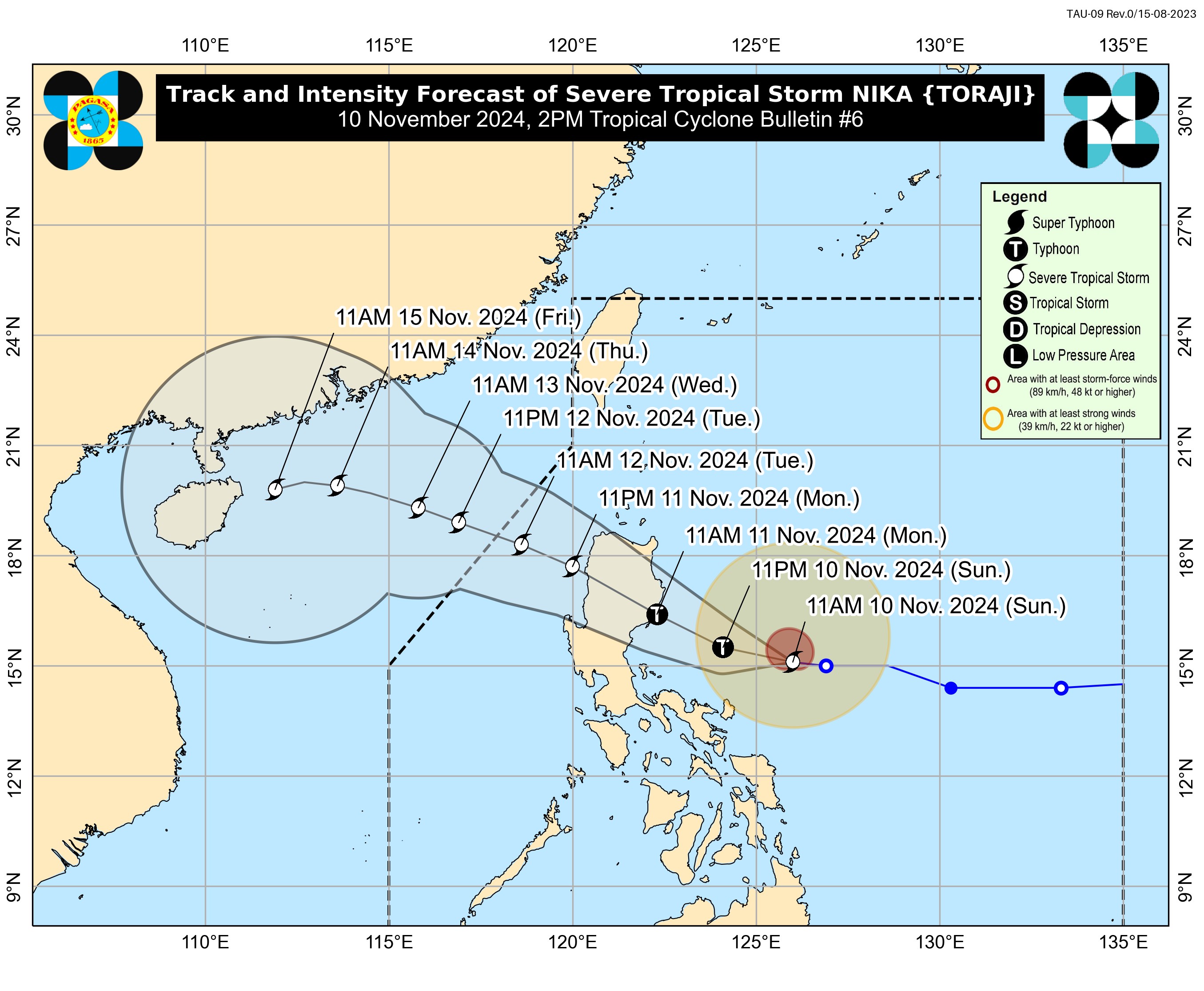
11 areas under Signal No. 2 as Nika intensifies

Signal No. 2 has been raised over 11 areas in Luzon as Severe Tropical Storm Nika slightly intensified as it moved west, state weather bureau PAGASA said Sunday afternoon.
In its 2 p.m. bulletin, PAGASA said Nika has maximum sustained winds of 110 km/h near the center and gustiness of up to 135 km/h.
The following areas under Signal No. 2 may experience winds of greater than 62 km/h and up to 88 km/h may be expected in at least 24 hours and may cause light to moderate damage to high risk structures:
- The northern and central portions of Aurora (Dilasag, Casiguran, Dinalungan, Dipaculao, Maria Aurora, Baler)
- Isabela
- Quirino
- the southern portion of Cagayan (Solana, Iguig, Peñablanca, Tuguegarao City, Enrile)
- Nueva Vizcaya
- Kalinga
- Mountain Province
- Ifugao
- the eastern portion of Benguet (Mankayan, Buguias, Kabayan, Itogon, Bokod, Atok)
- the northern portion of Nueva Ecija (Carranglan, Pantabangan)
- the northeastern portion of Pangasinan (San Nicolas, Natividad, San Quintin)
Signal No. 1 is hoisted over the following areas:
- The rest of Cagayan including Babuyan Island
- Apayao
- Abra
- Ilocos Norte
- Ilocos Sur
- the eastern and the rest of Pangasinan
- La Union
- the rest of Benguet
- the rest of Aurora
- Tarlac
- the northern and central portions of Zambales (Santa Cruz, Candelaria, Masinloc, Palauig, Iba,
- Botolan, Cabangan, San Marcelino, San Felipe, San Narciso)
- the rest of Nueva Ecija
- Pampanga
- Bulacan
- Metro Manila
- Rizal
- the eastern portion of Laguna (Santa Maria, Mabitac, Pakil, Pangil, Famy, Siniloan, Paete, Kalayaan, Cavinti, Lumban, Luisiana, Santa Cruz, Magdalena, Pagsanjan, Majayjay, Liliw, Nagcarlan, Pila, Victoria)
- the eastern portion of Quezon (Calauag, Guinayangan, Tagkawayan, Pitogo, San Andres, Buenavista, San Francisco, Pagbilao, Infanta, Lopez, Catanauan, Mulanay, Unisan, General Luna, Plaridel, Quezon, Alabat, Sampaloc, Padre Burgos, Macalelon, Mauban, Perez, Agdangan, Gumaca, Atimonan, Real, San Narciso, General Nakar, Lucban, City of Tayabas, Lucena City) including Pollilo Islands
- Camarines Norte
- Camarines Sur
- Catanduanes
- Albay (Malinao, Tiwi, Bacacay, City of Tabaco, Malilipot, Rapu-Rapu)
Winds of 39 to 61 km/h are expected in at least 36 hours and may cause very light or no damage to low risk structures.
The highest wind signal that may be raised during the occurrence of Nika is Signal No. 4, said PAGASA.
At 1 p.m., Nika was spotted 425 km east of Infanta, Quezon, moving westward at 30 km/h.
The northeasterly wind flow will also bring strong to gale-force gusts over the following areas:
- Sunday: Batanes
- Monday: Batanes, Batangas, Marinduque, Romblon, Camarines Sur, Catanduanes
- Tuesday: Batanes and Cagayan including Babuyan Islands
Coastal Waters
PAGASA also warned that a moderate to high risk of storm surge may occur in the next 48 hours in the low-lying or exposed coastal localities of Norte, Ilocos Sur, La Union, Pangasinan, Cagayan including Babuyan Islands, Isabela, Zambales, Aurora, Quezon including Polillo Islands, Camarines Norte, Camarines Sur, and Catanduanes.
Currently, a gale warning is hoisted over the eastern seaboard of Southern Luzon.
Up to very rough or high seas are thus expected over the following coastal waters:
- Up to 7.0 m: The seaboards of Isabela and northern Aurora
- Up to 5.5 m: The remaining seaboard of Aurora, the northern and eastern seaboards of Polillo Islands; the seaboard of Camarines Norte
- Up to 4.5 m: The eastern seaboard of mainland Cagayan; the northern seaboards of Camarines Sur and Catanduanes
Track, intensity
Nika is expected to reach typhoon category on Sunday and may reach its peak intensity prior to landfall.
“A short period of weakening is expected as NIKA traverses the landmass of Luzon due to land interaction. Re-intensification may occur over the West Philippine Sea,” the state weather bureau said.
Nika is also seen to move generally west northwestward throughout the forecast period and may make landfall over Isabela or Aurora on Monday morning or early afternoon.
It will then traverse the landmass of mainland Northern Luzon and emerge over the West Philippine Sea on Monday evening. It will continue moving west northwestward over the West Philippine Sea and exit the Philippine Area of Responsibility by Tuesday afternoon or evening—Mariel Celine Serquiña/RF, GMA Integrated News


