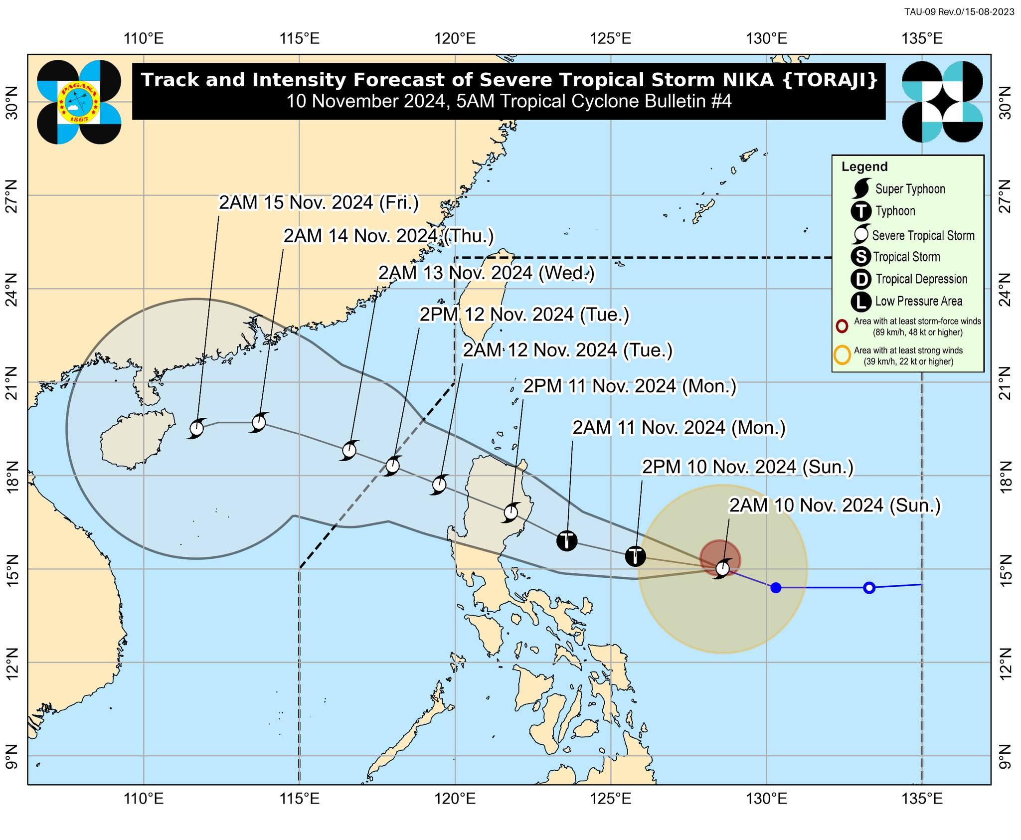
Nika now a severe tropical storm; Signal No. 2 up over parts of Isabela, Aurora

Tropical cyclone Nika (international name: Toraji) has intensified into a severe tropical storm early Sunday, according to PAGASA.
At 5 a.m., the weather bureau raised Tropical Cyclone Wind Signal (TCWS) No. 2 over:
- the southeastern portion of Isabela (Dinapigue); and
- the northern portion of Aurora (Dilasag, Casiguran, Dinalungan).
The above-mentioned areas may expect in 24 hours gale-force winds with speeds of 62 to 88 km/h which may pose minor to moderate threat to life and property.
TCWS No. 1 meanwhile is in effect in the following 17 Luzon areas:
- the southern portion of Cagayan (Tuguegarao City, Peñablanca, Enrile, Solana, Iguig);
- the rest of Isabela;
- Quirino;
- Nueva Vizcaya;
- the southeastern portion of Kalinga (City of Tabuk, Rizal, Tanudan);
- the eastern portion of Mountain Province (Paracelis, Natonin, Barlig);
- Ifugao;
- the eastern portion of Pangasinan (San Nicolas, Tayug, Natividad, San Quintin, Umingan);
- the rest of Aurora;
- Nueva Ecija;
- the northeastern portion of Pampanga (Candaba, Arayat);
- the northern and eastern portions of Bulacan (Norzagaray, San Miguel, San Ildefonso, San Rafael, Doña Remedios Trinidad, Angat);
- the eastern portion of Quezon (Calauag, Guinayangan, Tagkawayan, Pitogo, San Andres, Buenavista, San Francisco, Pagbilao, Infanta, Lopez, Catanauan, Mulanay, Unisan, General Luna, Plaridel, Quezon, Alabat, Sampaloc, Padre Burgos, Macalelon, Mauban, Perez, Agdangan, Gumaca, Atimonan, Real, San Narciso, General Nakar) including Polillo Islands;
- Camarines Norte;
- Camarines Sur;
- Catanduanes; and
- the northeastern portion of Albay (Malinao, Tiwi, Bacacay, City of Tabaco, Malilipot, Rapu-Rapu).
Areas under TCWS No. 1 may expect strong winds with speeds of 39 to 61 km/h in 36 hours which may lead to minimal to minor threat to life and property.
The highest TCWS that may be raised during the passage of Nika is TCWS No. 4.
At 4 a.m., the center of Nika was estimated to be located at 690 km east of Infanta, Quezon, packing maximum sustained winds of 100 km/h near the center with gustiness of up to 125 km/h and central pressure of 985 hPa.
Nika is moving west northwestward at 30 km/h.
From its center, strong to storm-force winds are extending outwards up to 300 km from the center.
PAGASA said Nika is currently undergoing rapid intensification and may become a typhoon today.
Rainfall
PAGASA said moderate to heavy rainfall of 50 mm to 100 mm are forecast on Sunday for Catanduanes, Camarines Norte, and Camarines Sur.
On Monday, Isabela, Cagayan and Aurora may expect intense to torrential rains of up to more than 200 mm.
Heavy to intense rains of 100 to 200 mm meanwhile may fall on Monday over Apayao, Kalinga, Mountain Province, Quirino, Nueva Vizcaya, Ifugao, and Abra.
Moderate to heavy rains from 50 to 100 mm may be felt on Monday over Catanduanes, Camarines Norte, Camarines Sur, Quezon, Nueva Ecija, Benguet, Ilocos Norte, and Ilocos Sur.
"Forecast rainfall may be higher in mountainous and elevated areas. Moreover, impacts in some areas maybe worsened by significant antecedent rainfall," PAGASA said.
Winds
The northeasterly windflow may also bring strong to gale-force gusts over Batanes, Babuyan Islands, northern Cagayan and Ilocos Norte today, especially in coastal and upland areas exposed to winds.
Storm surge
"There is a minimal to moderate risk of storm surge may occur in the next 48 hours in the low-lying or exposed coastal localities of Ilocos Norte, Ilocos Sur, La Union, Pangasinan, Cagayan including Babuyan Islands, Isabela, Zambales, Aurora, Quezon including Polillo Islands, Camarines Norte, Camarines Sur, Albay, and Catanduanes," PAGASA said.
Coastal waters
The eastern seaboards of Isabela and northern Aurora and the northern seaboard of Camarines Norte may have up to very rough seas of up to 4.5 meters on Sunday, making sea travel risky for all types or tonnage of vessels.
"All mariners must remain in port or, if underway, seek shelter or safe harbor as soon as possible until winds and waves subside," PAGASA said.
Meanwhile, the following areas may expect rough seas:
• Up to 4.0 m: The seaboards northern and eastern seaboards of Polillo Islands; the northern seaboard of Camarines Sur
• Up to 3.5 m: The northern seaboard of Catanduanes
• Up to 3.0 m: The remaining seaboard of Aurora; the eastern seaboards of Babuyan Islands, mainland Cagayan, northern Quezon and Catanduanes
PAGASA advised mariners of small seacrafts not to venture out to sea under these conditions.
The following coastal waters on the other hand will have up to moderate seas:
• Up to 2.5 m: The seaboards of Batanes and Ilocos Norte; the remaining seaboards of Babuyan Islands and mainland Cagayan; the eastern seaboards of Camarines Sur, Albay, and Sorsogon; the remaining seaboards of Catanduanes; the northern seaboard of Northern Samar.
• Up to 2.0 m: The remaining seaboards western and eastern seaboards of Luzon; the eastern seaboards of Eastern Visayas and Dinagat Islands
"Mariners of motorbancas and similarly-sized vessels are advised to take precautionary measures while venturing out to sea and, if possible, avoid navigation under these conditions," PAGASA said.
Track, intensity outlook
Nika may possibly make landfall over Isabela or Aurora on Monday afternoon.
After landfall, Nika is expected to weaken as it traverses the Luzon landmass, then intensify over the West Philippine Sea.
PAGASA advised the public and disaster risk reduction and management offices concerned to take the necessary measures to protect life and property.
The weather bureau will issue the next bulletin at 11 a.m.
LPA outside PAR
Meanwhile, a low pressure area (LPA) outside the Philippine Area of Responsibility (PAR) has a high chance of becoming a tropical depression within the next 24 hours, PAGASA said.
At 2 a.m., the LPA was estimated to be located at 2,365 km east of Northeastern Mindanao.
The LPA may possibly enter PAR by Tuesday early morning, according to DOST-PAGASA weather specialist Grace Castañeda in the weather bureau's public briefing. —KG, GMA Integrated News


