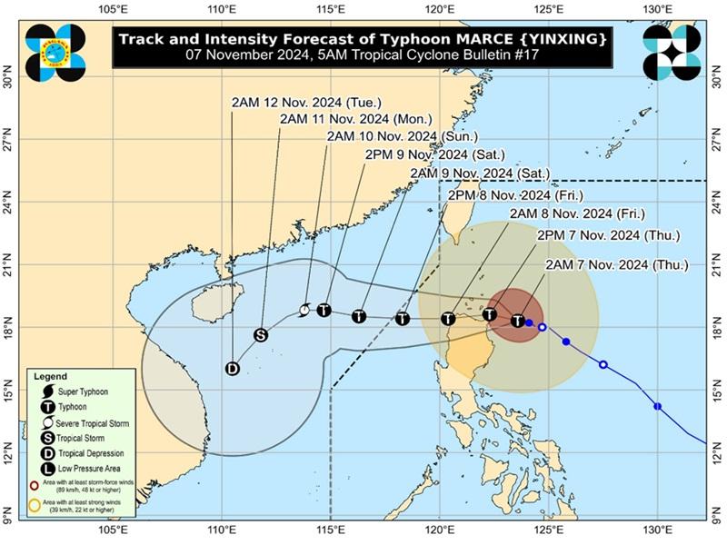
Marce maintains course, to make landfall over Babuyan Islands

Typhoon Marce continues to threaten the northern mainland Cagayan-Babuyan Islands area, to make landfall over Babuyan Islands as Signal No. 4 remains over two areas, according to the latest Tropical Cyclone Bulletin of PAGASA.
The center of the eye of Typhoon Marce was estimated at 200 kilometers east of Aparri, Cagayan packing maximum sustained winds of 155 kilometers per hour near the center, gustiness of up to 190 km/h, and central pressure of 955 hPa.
Marce is moving west northwestward at the speed of 15 kph with strong to typhoon-force winds extend outwards up to 560 km from the center.
Marce will make landfall and traverse Babuyan Islands and/or the northern portions of mainland Cagayan, Ilocos Norte, and Apayao (or pass very close to these areas) from this afternoon until tomorrow (8 November) early morning.
Tropical Cyclone Wind Signal (TCWS) No. 4 is hoisted over the following areas:
- the northern portion of mainland Cagayan (Gonzaga, Santa Ana, Santa Teresita, Lal-Lo, Buguey, Aparri, Camalaniugan, Gattaran, Ballesteros, Allacapan, Abulug, Pamplona, Sanchez-Mira) including Babuyan Islands
- the northeastern portion of Apayao (Santa Marcela)
TCWS No.3 is hoisted over the following areas:
- the southern portion of Batanes (Mahatao, Uyugan, Basco, Ivana, Sabtang)
- the rest of Cagayan
- the rest of Apayao
- Ilocos Norte
- the northern portion of Abra (Tineg)
TCWS No.2 is hoited over the following areas:
- the rest of Batanes
- the northern and central portions of Isabela (San Pablo, Santa Maria, Divilacan, Tumauini, Maconacon, Cabagan, Santo Tomas, Quezon, Palanan, Ilagan City, Mallig, Delfin Albano, Quirino, San Mariano, Gamu, Roxas, Naguilian, Burgos, Reina Mercedes, Benito Soliven, Luna, Aurora, San Manuel, San Mateo, Alicia, Angadanan, City of Cauayan, Cabatuan)
- the rest of Abra
- Kalinga
- Mountain Province
- the northern portion of Ifugao (Alfonso Lista, Aguinaldo, Mayoyao, Banaue, Hungduan)
- the northern portion of Benguet (Bakun, Mankayan)
- Ilocos Sur
- the northern portion of La Union (Sudipen, Bangar, Balaoan, Luna, Santol)
TCWS No.1 is hoisted over the following areas:
- the rest of La Union
- Pangasinan
- the rest of Ifugao
- the rest of Benguet
- the rest of Isabela
- Quirino
- Nueva Vizcaya
- the northern and central portions of Aurora (Dilasag, Casiguran, Dinalungan, Dipaculao, Maria Aurora, Baler)
- the northern portion of Nueva Ecija (Carranglan)
- the northern portion of Zambales (Santa Cruz, Candelaria)
Heavy Rainfall Outlook
Intense to torrential rain over Cagayan, Apayao, Ilocos Norte
Heavy to intense rain over Batanes, Ilocos Sur, Abra
Moderate to heavy rain over Kalinga, La Union, Isabela, Mountain Province
Severe Winds
There will be significant to severe impacts from typhoon-force winds are possible within any of the areas under Wind Signal No. 4, moderate to significant impacts from gale-force winds are possible within any of the areas under Wind Signal No. 3, minor to moderate impacts from gale-force winds are possible within any of the areas under Wind Signal No. 2 and minimal to minor impacts from strong winds are possible within any of the areas under Wind Signal No. 1.
PAGASA said the northeasterly wind flow and the periphery of MARCE will also bring strong to gale-force gusts over the following areas (especially in coastal and upland areas exposed to winds): Zambales, Bataan, and Polillo Islands
Coastal Inundation
The weather bureau said there is a high risk of life-threatening storm surge with peak surge heights exceeding 3.0 m above normal tide levels in the next 48 hours over the low-lying or exposed coastal localities of Batanes, Cagayan including Babuyan Islands, Isabela, Ilocos Norte, Ilocos Sur, and La Union.
Hazards affecting coastal waters
A Gale Warning is hoisted over the seaboards of Northern Luzon and Central Luzon.
Mariners are advised to take precautionary measures while venturing out to sea and, if possible, avoid navigation under these conditions.
Track and Intensity outlook
Typhoon Marce is forecast to move west northwestward for the next 12 hours over the waters east of Cagayan before turning generally westward from this afternoon until Saturday (9 November).
Marce will make landfall and traverse Babuyan Islands and/or the northern portions of mainland Cagayan, Ilocos Norte, and Apayao (or pass very close to these areas) from this afternoon until tomorrow (8 November) early morning then may exit the Philippine Area of Responsibility (PAR) region tomorrow evening. — BAP, GMA Integrated News


