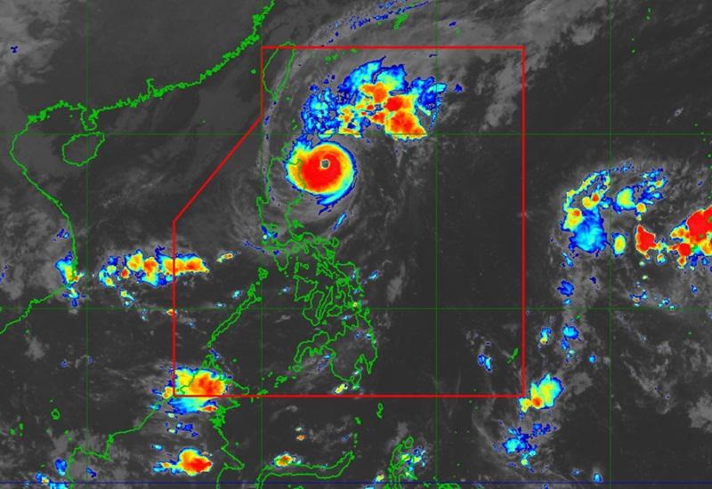
Marce maintains strength, accelerates; Signal No. 4 raised over Cagayan, Babuyan islands

Typhoon Marce maintains strength as it accelerates toward the northern mainland Cagayan-Babuyan Islands area with two areas under Signal No. 4, according to the latest Tropical Cyclone Bulletin posted by PAGASA.
The center of the eye of Typhoon Marce was estimated at 210 kilometers east of Aparri, Cagayan packing maximum sustained winds of 155 kilometers per hour near the center, gustiness of up to 190 kph, and central pressure of 955 hPa.
Marce is moving west northwestward at the speed of 15 kph with strong to typhoon-force winds extend outwards up to 560 km from the center.
Tropical Cyclone wind Signal (TCWS) No. 4 is hoisted over the following areas:
the northeastern portion of mainland Cagayan (Gonzaga, Santa Ana, Santa Teresita, Lal-Lo, Buguey, Aparri, Camalaniugan)
the southeastern portion of Babuyan Islands (Camiguin Is.)
TCWS No.3 is hoisted over the following areas:
the southern portion of Batanes (Mahatao, Uyugan, Basco, Ivana, Sabtang)
the rest of Babuyan Islands
the rest of Cagayan
Apayao
the northern portion of Ilocos Norte (Pagudpud, Dumalneg, Adams, Bangui, Burgos, Vintar, Carasi, Pasuquin)
TCWS No.2 is raised over the following areas:
the rest of Batanes
the northern and central portions of Isabela (San Pablo, Santa Maria, Divilacan, Tumauini, Maconacon, Cabagan, Santo Tomas, Quezon, Palanan, Ilagan City, Mallig, Delfin Albano, Quirino, San Mariano, Gamu, Roxas, Naguilian, Burgos, Reina Mercedes, Benito Soliven, Luna, Aurora, San Manuel, San Mateo, Alicia, Angadanan, City of Cauayan, Cabatuan)
Abra
Kalinga
Mountain Province
the northern portion of Ifugao (Alfonso Lista, Aguinaldo, Mayoyao, Banaue, Hungduan)
the rest of Ilocos Norte
the northern and central portions of Ilocos Sur (Sinait, Cabugao, San Juan, Magsingal, Santo Domingo, Bantay, San Ildefonso, San Vicente, Santa Catalina, City of Vigan, Narvacan, Caoayan, Santa, Nagbukel, Santa Maria, San Esteban, Santiago, Burgos, Banayoyo, Lidlidda, San Emilio, City of Candon, Salcedo, Galimuyod, Santa Lucia, Gregorio del Pilar, Quirino, Sigay, Cervantes, Suyo, Santa Cruz)
TCWS No.1 is raised over the following areas:
the rest of Ilocos Sur
La Union
Pangasinan
the rest of Ifugao
Benguet
the rest of Isabela
Quirino
Nueva Vizcaya
the northern and central portions of Aurora (Dilasag, Casiguran, Dinalungan, Dipaculao, Maria Aurora, Baler)
the northern portion of Nueva Ecija (Carranglan)
the northern portion of Zambales (Santa Cruz, Candelaria)
Heavy Rainfall Outlook
There will be intense to torrential rain over Cagayan, Apayao, and Ilocos Norte
Heavy to intense rain is expected over Batanes, Ilocos Sur, and Abra
Moderate to heavy rain over Kalinga, Pangasinan, La Union, Benguet, Isabela, and Mountain Province
Severe Winds
"The wind signals warn the public of the general wind threat over an area due to the tropical cyclone. Local winds may be slightly stronger/enhanced in coastal and upland/mountainous areas exposed to winds. Winds are less strong in areas sheltered from the prevailing wind direction, said PAGASA.
There will be severe impacts from typhoon-force winds are possible within any of the areas under Wind Signal No. 4, moderate to significant impacts from gale-force winds are possible within any of the areas under Wind Signal No. 3, minor to moderate impacts from gale-force winds are possible within any of the areas under Wind Signal No. 2 and minimal to minor impacts from strong winds are possible within any of the areas under Wind Signal No. 1.
The northeasterly wind flow and the periphery of Marce will also bring strong to gale-force gusts over the following areas (especially in coastal and upland areas exposed to winds): Zambales, Bataan, and Polillo Islands.
Coastal Inundation
PAGASA reports that there is a high risk of life-threatening storm surge with peak surge heights exceeding 3.0 m above normal tide levels in the next 48 hours over the low-lying or exposed coastal localities of Batanes, Cagayan including Babuyan Islands, Isabela, Ilocos Norte, Ilocos Sur, and La Union.
Hazards affecting coastal waters
A Gale Warning is hoisted over the seaboards of Northern Luzon and the eastern seaboard of Central Luzon.
Mariners are advised to take precautionary measures while venturing out to sea and, if possible, avoid navigation under these conditions.
Track and Intensity outlook
Marce, PAGASA said, is forecast to move west northwestward for the next 12 hours over the waters east of Cagayan before turning westward from this afternoon until Saturday.
Marce will make landfall and traverse Babuyan Islands and/or the northern portions of mainland Cagayan, Ilocos Norte, and Apayao (or pass very close to these areas) from this afternoon until Friday early morning and may exit the Philippine Area of Responsibility (PAR) region by Friday evening. — BAP, GMA Integrated News


