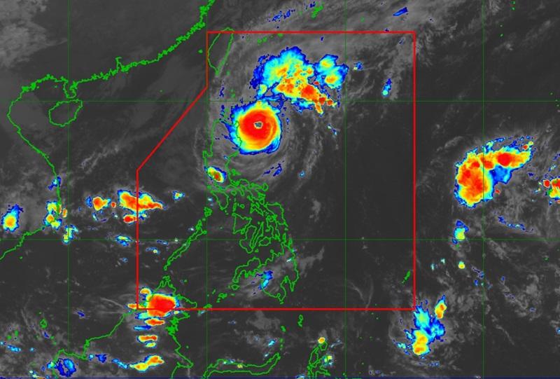
Marce intensifies as it nears Cagayan-Babuyan Islands area

Typhoon Marce has further intensified as it moves closer to the northern mainland Cagayan-Babuyan Islands area, according to PAGASA’s 11 p.m. cyclone bulletin.
At 10 p.m. Marce was observed at 240 kilometers east of Aparri, Cagayan with maximum sustained winds of 155 kph, gustiness of up to 190 kph and moving west northwestward at 10 kph.
PAGASA said Marce will remain a typhoon throughout its time inside the Philippine Area of Responsibility (PAR).
Signal no. 3 is hoisted in the following areas:
- The northern and central portions of mainland Cagayan (Santa Ana, Gonzaga, Lal-Lo, Santa Teresita, Buguey, Aparri, Camalaniugan, Allacapan, Gattaran, Lasam, Ballesteros, Baggao, Alcala, Santo Niño, Rizal, Abulug, Pamplona, Sanchez-Mira, Claveria, Santa Praxedes) including Babuyan Islands
- the eastern portion of Apayao (Flora, Santa Marcela, Luna, Pudtol)
PAGASA warned that the affected areas may observe winds of 89 kph to 117 kph over the next 18 hours
The following areas under Signal no. 2 may experience winds of 62 kph up to 88 kph within 24 hours:
- Batanes
- the rest of mainland Cagayan
- the northern and central portions of Isabela (San Pablo, Santa Maria, Divilacan, Tumauini, Maconacon, Cabagan, Santo Tomas, Quezon, Palanan, Ilagan City, Mallig, Delfin Albano, Quirino, San Mariano, Gamu, Roxas, Naguilian, Burgos, Reina Mercedes, Benito Soliven, Luna, Aurora, San Manuel)
- the rest of Apayao
- Abra
- Kalinga
- the eastern and central portions of Mountain Province (Paracelis, Natonin, Barlig, Sadanga)
- Ilocos Norte
- the northern portion of Ilocos Sur (Sinait, Cabugao, San Juan, Magsingal, Santo Domingo, Bantay, San Ildefonso, San Vicente, Santa Catalina, City of Vigan, Narvacan, Caoayan, Santa, Nagbukel, Santa Maria, San Esteban, Santiago, Burgos, Banayoyo, Lidlidda, San Emilio)
Winds of 39 kph to 61 kph or intermittent rains are expected over the next 36 hours in the following areas under Signal no. 1:
- the rest of Ilocos Sur
- La Union
- the northern portion of Pangasinan (Bani, Bolinao, Anda, City of Alaminos, Agno, Sual, Labrador, Burgos, Mabini, Lingayen, Binmaley, Dagupan City, Mangaldan, San Fabian, San Jacinto, Pozorrubio, Sison, San Manuel, San Nicolas, Natividad, San Quintin, Tayug, Santa Maria, Binalonan, Asingan, Laoac, Manaoag, Mapandan, Santa Barbara, Calasiao, City of Urdaneta)
- the rest of Mountain Province
- Ifugao
- Benguet
- the rest of Isabela
- Quirino
- Nueva Vizcaya
- the northern portion and central portions of Aurora (Dilasag, Casiguran, Dinalungan, Dipaculao, Maria Aurora, Baler)
- the northern portion of Nueva Ecija (Carranglan)
The weather bureau said that there is a high risk of life-threatening storm surge with peak surge heights exceeding 3.0 m above normal tide levels in the next 48 hours over the low-lying or exposed coastal localities of Batanes, Cagayan including Babuyan Islands, Isabela, Ilocos Norte, Ilocos Sur, and La Union.
A Gale Warning is hoisted over the seaboards of Northern Luzon and the eastern seaboard of Central Luzon.
PAGASA also warned about the possibility of raising Signal no. 4 as the highest wind signal within the forecast period.
Marce is predicted to continue moving slowly over east of Cagayan on Wednesday night and gradually accelerate over the Babuyan Channel and the northern portion of the West Philippine Sea from Thursday to Saturday.
PAGASA said Marce may make a landfall near Babuyan Islands and/or the northern portions of mainland Cagayan, Ilocos Norte, and Apayao from Thursday afternoon to Friday early morning, before exiting the PAR by Friday evening.
“Marce may have reached its peak intensity. Slight weakening is expected due to possible interaction with the terrain of mainland Luzon during the landfall or close approach of Marce,” PAGASA said. — BAP, GMA Integrated News


