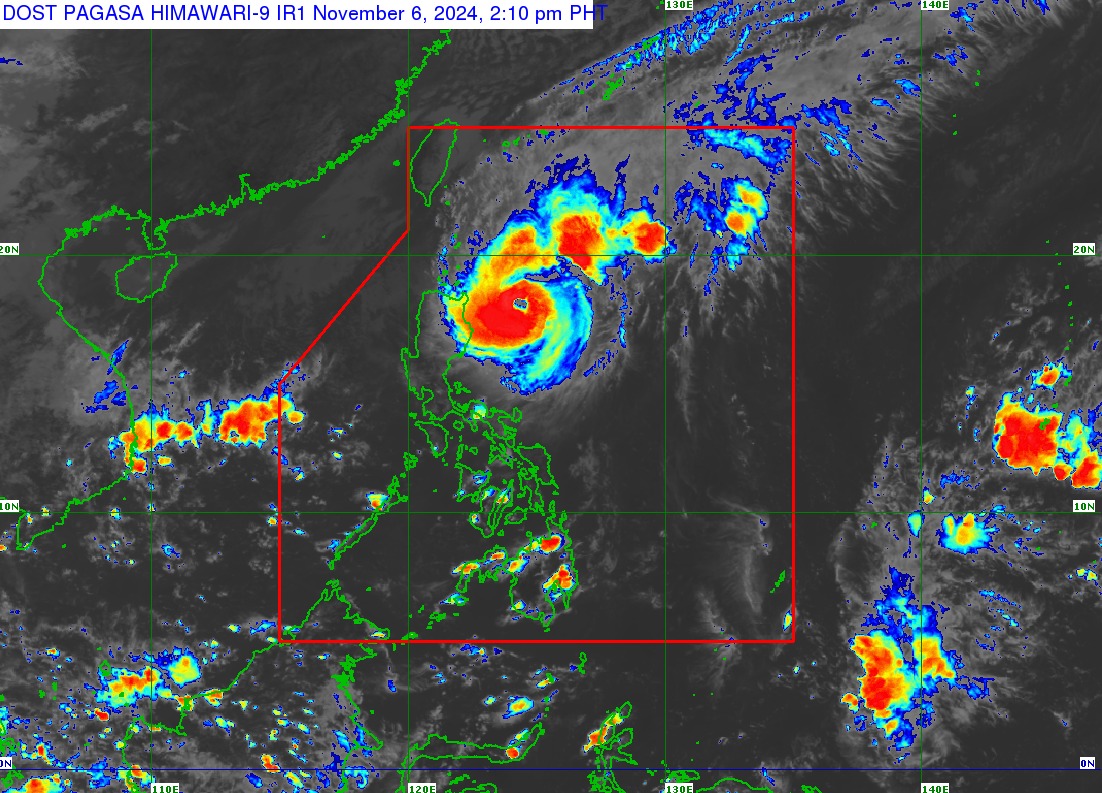
Signal No. 3 up over northeastern Cagayan as Marce maintains strength

Tropical Cyclone Wind Signal (TCWS) No. 3 is raised over the northeastern portion of mainland Cagayan, particularly Santa Ana and Gonzaga towns, as Typhoon Marce "remains slow-moving," according to PAGASA.
In its 2 p.m. bulletin, PAGASA raised the following Tropical Cyclone Wind Signals (TCWS).
Signal No. 3
- The northeastern portion of mainland Cagayan (Santa Ana, Gonzaga)
Signal No. 2
- Batanes
- The rest of Cagayan including Babuyan Islands
- The northern portion of Isabela (Maconacon, San Pablo, Santa Maria, Divilacan)
- Apayao
- The northern portion of Kalinga (Rizal, Pinukpuk, Balbalan)
- The northern portion of Abra (Langiden, Bangued, Danglas, Tayum, La Paz, Dolores, Lagayan, San Juan, Lagangilang, Tineg, Lacub, Licuan-Baay, Malibcong)
- Ilocos Norte
- The northern portion of Ilocos Sur (Sinait, Cabugao, San Juan, Magsingal, Santo Domingo, Bantay, San Ildefonso, San Vicente, Santa Catalina)
- The rest of Ilocos Sur
- La Union
- The northwestern portion of Pangasinan (Bani, Bolinao, Anda, City of Alaminos, Agno, Sual)
- The rest of Abra
- The rest of Kalinga
- Mountain Province
- Ifugao, Benguet
- The rest of Isabela
- Quirino
- Nueva Vizcaya
- The northern portion of Aurora (Dilasag, Casiguran, Dinalungan, Dipaculao, Maria Aurora, Baler)

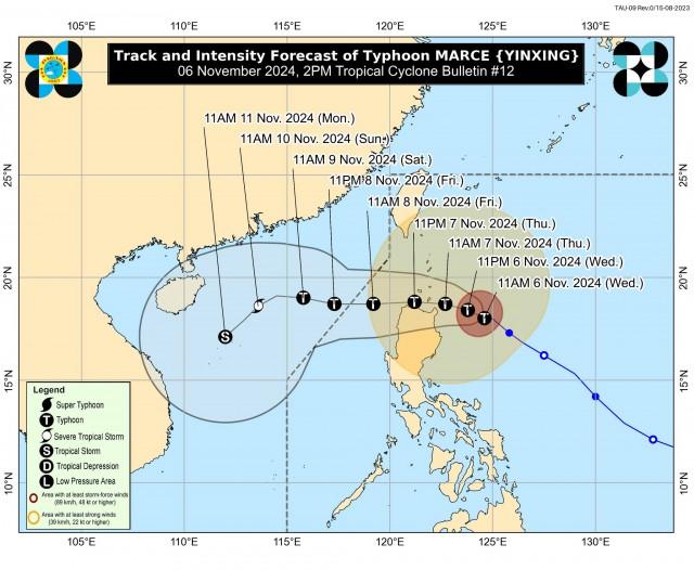
Marce was last spotted 295 kilometers east of Aparri, Cagayan moving westward with maximum sustained winds of 150 kilometers per hour (kph) near the center and gustiness of up to 185 kph.
“MARCE will make landfall and traverse Babuyan Islands or the northern portions of mainland Cagayan, Ilocos Norte, and Apayao or pass very close to these areas from tomorrow afternoon to Friday (8 November) early morning,” PAGASA said.
“MARCE is expected to continue intensifying and may reach its peak intensity today before its passage over the Babuyan Channel. Slight weakening is expected due to possible interaction with the terrain of mainland Luzon, although MARCE will remain as a typhoon throughout its passage within the PAR region,” it added.
According to PAGASA, Marce is expected to exit the Philippine area of responsibility (PAR) on Friday evening.
Storm surge
PAGASA said there is a high risk of “life-threatening storm surge” in Batanes, Cagayan including Babuyan Islands, Isabela, Ilocos Norte, Ilocos Sur, and La Union.
“There is a high risk of life-threatening storm surge with peak surge heights exceeding 3.0 m above normal tide levels in the next 48 hours over the low-lying or exposed coastal localities of Batanes, Cagayan including Babuyan Islands, Isabela, Ilocos Norte, Ilocos Sur, and La Union,” PAGASA said.
Rains
Heavy to intense rains are expected over Cagayan while moderate to heavy rains are forecast for Batanes, Isabela and Aurora on Wednesday, according to PAGASA.
“Under these conditions, flooding and rain-induced landslides are likely, especially in areas that are highly or very highly susceptible to these hazards as identified in hazard maps and in areas with significant antecedent rainfall,” PAGASA said.
“The public and disaster risk reduction and management offices concerned are advised to take all necessary measures to protect life and property,” it added.
Winds
Due to gale-force winds, areas under TCWS No. 3 may experience moderate to significant impacts, while TCWS No. 2 areas may encounter minor to moderate impacts. In areas under TCWS No. 1, minimal to minor impacts from strong winds are expected.
“The highest Wind Signal which may be hoisted during the occurrence of MARCE is Wind Signal No. 4,” PAGASA said.
Due to the northeasterly wind flow and the periphery of Marce, strong to gale-force gusts will be felt over most of Cagayan Valley, Cordillera Administrative Region, Ilocos Norte, Ilocos Sur, and Pangasinan on Wednesday.
Waves
A Gale Warning is raised over the seaboards of Northern Luzon and the eastern seaboard of Central Luzon, PAGASA said.
Very rough, high, or very high seas (from 4.5 to 12.0 meters) are expected over the following coastal waters:
- Up to 12.0 m: The eastern seaboard of Babuyan Islands, the northeastern seaboard of mainland Cagayan
- Up to 8.0 m: The seaboard of Batanes; the remaining seaboard of Babuyan Islands; the northern seaboard of mainland Cagayan.
- Up to 7.0 m: The remaining seaboard of mainland Cagayan; the northern seaboard of Ilocos Norte.
- Up to 6.0 m: The remaining seaboard of Ilocos Norte; the seaboard of Isabela
- Up to 5.5 m: The seaboard of Ilocos Sur
- Up to 4.5 m: The remaining seaboard of Ilocos Region; the seaboard of northern Aurora
“Sea travel is risky for all types or tonnage of vessels. All mariners must remain in port or, if underway, seek shelter or safe harbor as soon as possible until winds and waves subside,” PAGASA said.
Rough seas (from 3.0 to 4.8 meters) may be encountered in the following areas:
- Up to 4.0 m: The seaboard of northern Zambales
- Up to 3.5 m: The northern and eastern seaboards of Polillo Islands; the seaboard of Camarines Norte; the northern seaboards of Catanduanes and Camarines Sur.
- Up to 3.0 m: The eastern seaboards of Catanduanes and Northern Samar; the remaining seaboard of Zambales; the seaboard of Kalayaan Islands
“Mariners of small seacrafts, including all types of motorbancas, are advised not to venture out to sea under these conditions, especially if inexperienced or operating ill-equipped vessels,” PAGASA said.
Moderate seas (2.0 to 2.5 meters) may be experienced over the following coastal waters:
- Up to 2.5 m: The northern seaboard of Northern Samar; the eastern seaboards of Albay, Sorsogon, and Eastern Samar; the western seaboards of Bataan, Lubang Islands, mainland northern Palawan, and Calamian Islands;
- Up to 2.0 m: The western seaboards of Occidental Mindoro and the rest of mainland Palawan; the eastern seaboard of Camarines Sur and Dinagat Islands
“Mariners of motorbancas and similarly-sized vessels are advised to take precautionary measures while venturing out to sea and, if possible, avoid navigation under these conditions,” PAGASA said.
—VAL, GMA Integrated News


