Signal No. 1 up over 12 Luzon areas as Marce intensifies into a typhoon

Tropical Cyclone Wind Signal No. 1 is raised over 12 areas in Luzon as Marce intensified into a typhoon on Tuesday morning, according to state weather bureau PAGASA.
In its 11 a.m. bulletin, PAGASA said the following areas are under TCWS No.1:
- Batanes
- Cagayan including Babuyan Islands
- Isabela
- Ilocos Norte
- Apayao
- Abra
- Kalinga
- Mountain Province
- Ifugao
- The northern portion of Nueva Vizcaya (Diadi, Bagabag, Ambaguio, Villaverde, Bayombong, Solano, Quezon, Kasibu)
- The northern portion of Quirino (Diffun, Saguday, Cabarroguis, Aglipay, Maddela)
- The northern portion of Aurora (Dilasag, Casiguran, Dinalungan)

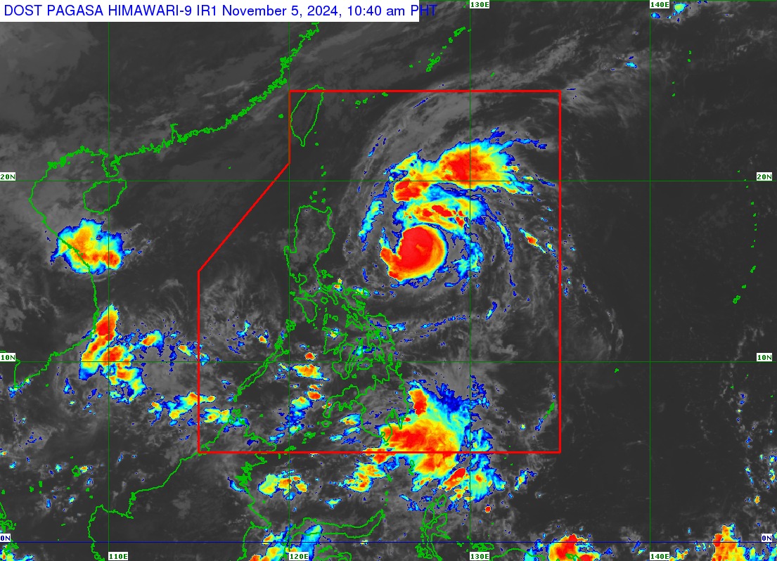
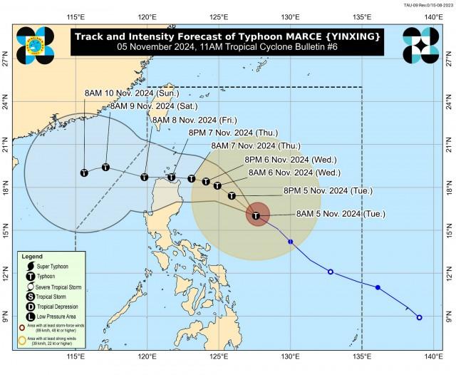
Marce was last spotted 590 kilometers east of Baler, Aurora moving west northwestward at 30 kilometers per hour (kph), PAGASA said.
The typhoon was packing maximum sustained winds of 120 kph near the center and gustiness of up to 150 kph, it added.
PAGASA said Marce may make landfall in the vicinity of Babuyan Islands or over the northern portion of mainland Cagayan on Thursday evening or Friday early morning.
Due to uncertainty in the strength of the high pressure area north of Marce, PAGASA said the forecast track may still change and bring the landfall point to the mainland Cagayan-Isabela area.
“MARCE is expected to continue intensifying and may reach its peak intensity prior to possible landfall over Babuyan Islands or Cagayan,” PAGASA said.
The National Disaster Risk Reduction and Management Council (NDRRMC) has remained on heightened alert due to Marce.
NDRRMC chairperson and Defense chief Gilberto Teodoro Jr. said concerned agencies are closely monitoring the situation with Marce.
Some areas in Cagayan suspended classes on Tuesday, Nov. 5, due to the possible effects of Marce
The typhoon may exit the Philippine area of responsibility on Friday evening or Saturday early morning, according to PAGASA.
Heavy rains
Moderate to heavy rains are expected in Cagayan from Tuesday noon to Wednesday noon.
“Under these conditions, flooding and rain-induced landslides are likely, especially in areas that are highly or very highly susceptible to these hazards as identified in hazard maps and in areas with significant antecedent rainfall,” PAGASA said.
Strong winds may lead to minimal to minor impacts in areas under TCWS No. 1, according to PAGASA.
Due to the northeasterly wind flow, strong to gale-force gusts may be experienced over Ilocos Sur, Aurora, Quezon, and Camarines Norte on Tuesday.
“The highest Wind Signal which may be hoisted during the occurrence of MARCE is Wind Signal No. 4,” PAGASA said.
Rough seas
A Gale Warning is raised over the northern and eastern seaboards of Northern Luzon, according to PAGASA.
Waves of up to 6.0 meters are expected over the seaboards of Batanes and Babuyan Islands as well as the eastern seaboard of mainland Cagayan.
“Sea travel is risky for all types or tonnage of vessels. All mariners must remain in port or, if underway, seek shelter or safe harbor as soon as possible until winds and waves subside,” PAGASA said.
Very rough seas of up to 5.5 meters may be experienced over the following areas:
Up to 5.5 m - the seaboard of Isabela
Up to 5.0 m - the northern seaboards of Ilocos Norte and mainland Cagayan
Up to 4.5 m - the western seaboard of Ilocos Norte
“Sea travel is risky for all types or tonnage of vessels. All mariners must remain in port or, if underway, seek shelter or safe harbor as soon as possible until winds and waves subside,” PAGASA said.
Rough seas of up to 4.0 meters are expected in the following coastal waters:
Up to 4.0 m - the seaboards of northern Aurora and Ilocos Sur.
Up to 3.5 m - the remaining seaboard of Ilocos Region; the northern and eastern seaboards of Polillo Islands; the seaboard of Camarines Norte; the northern seaboard of Catanduanes and Camarines Sur.
Up to 3.0 m - the western seaboard of Zambales; the eastern seaboard of Catanduanes.
“Mariners of small seacrafts, including all types of motorbancas, are advised not to venture out to sea under these conditions, especially if inexperienced or operating ill-equipped vessels,” PAGASA said.
Meanwhile, moderate seas of up to 2.5 meters may be experienced in the following areas:
Up to 2.5 m - the eastern seaboards of Albay and Sorsogon; the northern and eastern seaboards of Northern Samar.
Up to 2.0 m - he eastern seaboards of Camarines Sur, Eastern Samar, Dinagat Islands, Surigao del Sur, Davao Oriental, and Davao del Sur; the western seaboards of Bataan, Lubang Islands, Calamian Islands, Kalayaan Islands and northern mainland Palawan.
“Mariners of motorbancas and similarly-sized vessels are advised to take precautionary measures while venturing out to sea and, if possible, avoid navigation under these conditions,” PAGASA said.
—VAL, GMA Integrated News


