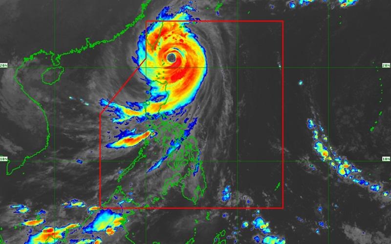
Signal No. 5 remains over northern, eastern Batanes

Violent conditions are being experienced over Batanes as Super Typhoon Leon continues to move northwestward over the seas of extreme Northern Luzon, according to the latest Tropical Cyclone Bulletin posted by PAGASA.
The center of the eye of Super Typhoon Leon was estimated at 115 kilometers east northeast of Basco, Batanes or 120 km East of Itbayat, Batanes packing maximum sustained winds of 195 kilometers per hour near the center, gustiness of up to 240 km/h, and central pressure of 920 hPa.
Leon is moving northwestward at the speed of 25 kph with strong to typhoon-force winds extend outwards up to 600 km from the center.
Tropical Cyclone Wind Signal (TCWS) No. 5 is hoisted over the following areas:
- the northern and eastern portions of Batanes (Itbayat, Basco)
TCWS No. 4 is hoisted over the following areas:
- the rest of Batanes
TCWS No. 3 is raised over the following areas:
- the eastern portion of Babuyan Islands (Babuyan Is., Camiguin Is., Calayan Is.)
- the northeastern portion of mainland Cagayan (Santa Ana)
TCWS No. 2 is raised over the following areas:
- The rest of Babuyan Islands
- the rest of mainland Cagayan
- the northern portion of Isabela (Santo Tomas, Santa Maria, Quezon, Delfin Albano, San Pablo, Ilagan City, Tumauini, Cabagan, Palanan, Quirino, Divilacan, Mallig, Maconacon)
- Apayao
- the northern portion of Kalinga (City of Tabuk, Balbalan, Pinukpuk, Rizal)
- the northern portion of Abra (Tineg, Lacub, Malibcong)
- Ilocos Norte
TCWS No. 1 is hoisted over the following areas:
- the rest of Isabela
- Quirino
- Nueva Vizcaya
- the rest of Abra
- the rest of Kalinga
- Mountain Province
- Ifugao
- Benguet
- Ilocos Sur
- La Union
- the northern and central portions of Pangasinan (Basista, Lingayen, Villasis, City of Alaminos, Anda, Malasiqui, Tayug, San Fabian, Mangaldan, Mapandan, Burgos, Dagupan City, Binalonan, Bolinao, Alcala, San Manuel, Sual, Umingan, Asingan, Labrador, Bani, Santo Tomas, Pozorrubio, San Quintin, Santa Maria, City of Urdaneta, Laoac, Natividad, Mabini, San Carlos City, Manaoag, Binmaley, San Jacinto, Bugallon, Agno, Calasiao, San Nicolas, Santa Barbara, Balungao, Sison, Rosales, Dasol)
- the northern and eastern portions of Nueva Ecija (Bongabon, Carranglan, Pantabangan, Laur, Rizal, Cuyapo, Talavera, Santo Domingo, Llanera, Science City of Muñoz, General Mamerto Natividad, San Jose City, Lupao, Talugtug, Gabaldon)
- the northern and central portions of Aurora (Casiguran, Dinalungan, Baler, Maria Aurora, Dipaculao, San Luis, Dilasag)
Heavy Rainfall Outlook
PAGASA reported in Weather Advisory No. 14 that intense to torrential rains is expected over Batanes.
Heavy to intense rains is forecast over Babuyan Islands, Occidental Mindoro, and Calamian Islands while moderate to heavy rain is expected over Ilocos Norte, Ilocos Sur, Benguet, La Union, Pangasinan, Zambales and Bataan.
Severe Winds
The wind signals warn the public of the general wind threat over an area due to the tropical cyclone. Local winds may be slightly stronger/enhanced in coastal and upland/mountainous areas exposed to winds. Winds are less strong in areas sheltered from the prevailing wind direction.
Extreme impacts from typhoon-force winds are possible within any of the areas under Wind Signal No. 5 while significant to severe impacts from typhoon-force winds are possible within any of the areas under Wind Signal No. 4.
Moderate to significant impacts from storm-force winds are possible within any of the areas under Wind Signal No 3 and in areas under Wind signal No. 2, there would be minor to moderate impacts from gale-force winds and minimal to minor impacts from strong winds are possible within any of the areas under Wind Signal No. 1.
The wind flow coming towards the circulation of LEON will also bring gusty conditions (strong to gale-force) over the following localities (especially in coastal and upland areas exposed to winds) outside Wind Signal areas: Most of Cordillera Administrative Region, Quirino, Nueva Vizcaya, Aurora, Bataan, Metro Manila, CALABARZON, MIMAROPA, Bicol Region, Northern Samar and most of Western Visayas.
Coastal Inundation
The state weather bureau said that within the next 48 hours, there is a high risk of life-threatening storm surge with peak heights exceeding 3.0 m above normal tide levels over the low-lying or exposed coastal localities of Batanes and Babuyan Islands.
Hazards affecting coastal waters
A Gale Warning is hoisted over the seaboard of Northern Luzon and the eastern seaboards of Central and Southern Luzon.
Sea travel is risky all types or tonnage of vessels and all mariners must remain in port or, if underway, seek shelter or safe harbor as soon as possible until winds and waves subside.
Track and Intensity outlook
Leon is forecast to move northwestward over the seas of Extreme Northern Luzon until it makes landfall along the eastern coast of Taiwan by Thursday afternoon, said PAGASA.
After crossing the landmass of Taiwan, Leon will then turn northward to north northeastward over the Taiwan Strait towards the East China Sea and exit the Philippine Area of Responsibility tonight or Friday morning.
Leon will be closest to Batanes from tonight to tomorrow morning. A landfall in Batanes is not ruled out and will be near or at peak intensity during its closest point of approach to Batanes. — BAP, GMA Integrated News


