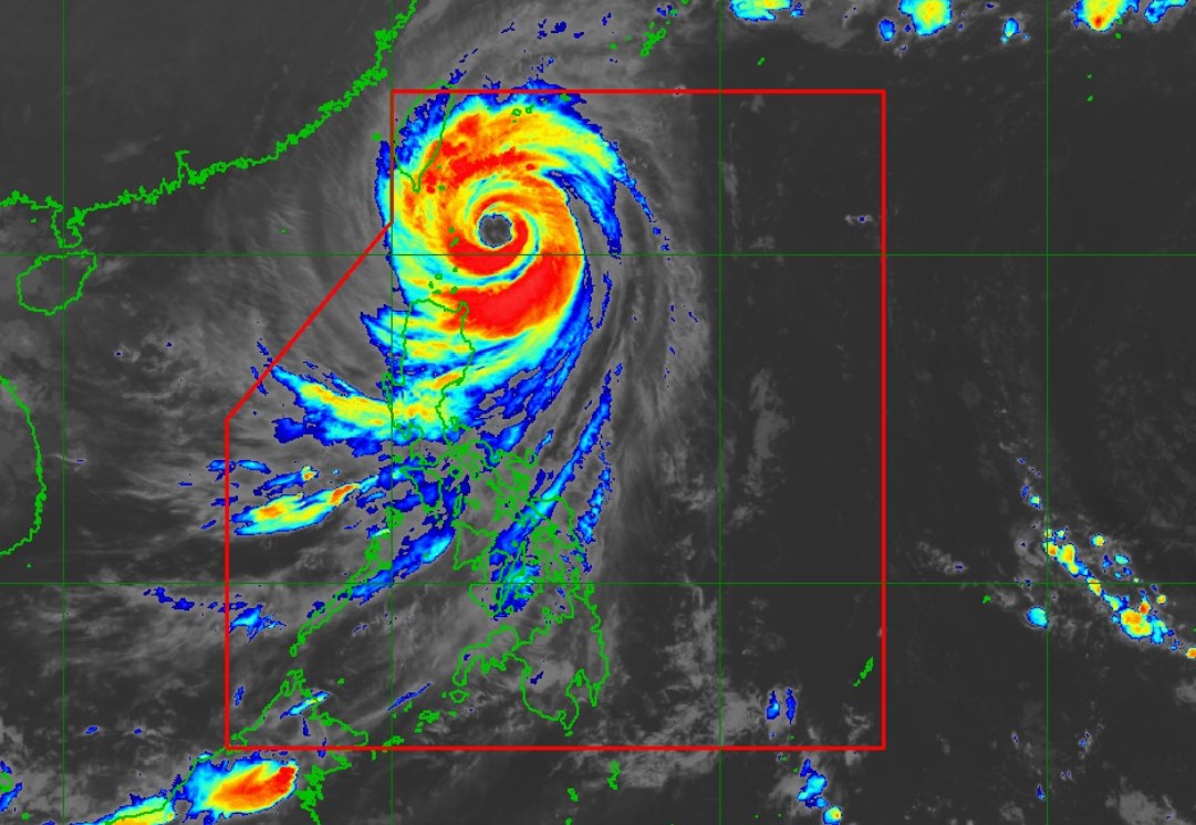
PAGASA: Northern, eastern Batanes under Signal No. 5

Violent conditions are being experienced over Batanes with Signal No. 5 hoisted over its northern and eastern portions as Super Typhoon Leon moved closer to extreme Northern Luzon, PAGASA said late Wednesday night.
The center of the eye of Super Typhoon Leon was estimated at 140 kilometers east of Basco, Batanes packing maximum sustained winds of 185 kilometers per hour near the center, gustiness of up to 230 kph, and central pressure of 925 hPa.
Leon is moving northwestward at the speed of 15 kph with strong to typhoon-force winds extend outwards up to 600 km from the center.
Tropical Cyclone Wind Signal (TCWS) No. 5 is hoisted over Itbayat and Basco in Batanes with winds from 118 to 184 kph and significant to severe threat to life and property.
Signal No. 4 remains hoisted over the rest of Batanes.
Signal No. 3 is hoisted over the following areas:
- The eastern portion of Babuyan Islands (Babuyan Is., Camiguin Is., Calayan Is.)
- the northeastern portion of mainland Cagayan (Santa Ana)
Signal No. 2 is raised over the following areas:
- The rest of Babuyan Islands
- the rest of mainland Cagayan
- the northern portion of Isabela (Santo Tomas, Santa Maria, Quezon, Delfin Albano, San Pablo, Ilagan City, Tumauini, Cabagan, Palanan, Quirino, Divilacan, Mallig, Maconacon)
- Apayao
- the northern portion of Kalinga (City of Tabuk, Balbalan, Pinukpuk, Rizal), the northern portion of Abra (Tineg, Lacub, Malibcong)
- Ilocos Norte
Signal No. 1 is hoisted over:
- the rest of Isabela
- Quirino
- Nueva Vizcaya
- the rest of Abra
- the rest of Kalinga
- Mountain Province
- Ifugao
- Benguet
- Ilocos Sur
- La Union
- the northern and central portions of Pangasinan (Basista, Lingayen, Villasis, City of Alaminos, Anda, Malasiqui, Tayug, San Fabian, Mangaldan, Mapandan, Burgos, Dagupan City, Binalonan, Bolinao, Alcala, San Manuel, Sual, Umingan, Asingan, Labrador, Bani, Santo Tomas, Pozorrubio, San Quintin, Santa Maria, City of Urdaneta, Laoac, Natividad, Mabini, San Carlos City, Manaoag, Binmaley, San Jacinto, Bugallon, Agno, Calasiao, San Nicolas, Santa Barbara, Balungao, Sison, Rosales, Dasol)
- the northern and eastern portions of Nueva Ecija (Bongabon, Carranglan, Pantabangan, Laur, Rizal, Cuyapo, Talavera, Santo Domingo, Llanera, Science City of Mu oz, General Mamerto Natividad, San Jose City, Lupao, Talugtug, Gabaldon)
- the northern and central portions of Aurora (Casiguran, Dinalungan, Baler, Maria Aurora, Dipaculao, San Luis, Dilasag)
Severe Winds
"The wind signals warn the public of the general wind threat over an area due to the tropical cyclone. Local winds may be slightly stronger/enhanced in coastal and upland/mountainous areas exposed to winds. Winds are less strong in areas sheltered from the prevailing wind direction," PAGASA explained.
- Extreme impacts from typhoon-force winds are possible within any of the areas under Wind Signal No. 5.
- Significant to severe impacts from typhoon-force winds are possible within any of the areas under Wind Signal No. 4.
- Moderate to significant impacts from storm-force winds are possible within any of the areas under Wind Signal No 3.
- Minor to moderate impacts from gale-force winds are possible within any of the areas under Wind Signal No. 2.
- Minimal to minor impacts from strong winds are possible within any of the areas under Wind Signal No. 1.
The wind flow coming towards the circulation of LEON will also bring gusty conditions (strong to gale-force) over the following localities (especially in coastal and upland areas exposed to winds) outside Wind Signal areas: Bataan, Metro Manila, CALABARZON, MIMAROPA, Bicol Region, most of Visayas, and Dinagat Islands.
According to the state weather bureau, Leon will be closest to Batanes from late evening today to tomorrow morning.
"A landfall in Batanes is also not ruled out," PAGASA said.
"This super typhoon will be near or at peak intensity during its closest point of approach to Batanes. The landfall of Leon over Taiwan will result in a continuous weakening trend for the rest of the forecast period," it added.
The typhoon is forecast to move northwestward over the Philippine Sea until it makes landfall along the eastern coast of Taiwan on Thursday afternoon.
Leon is expected to exit the Philippine Area of Responsibility on Thursday evening or early Friday morning.
According to a report on "24 Oras," Batanes Governor Marilou Cayco said it was the first time that about 100 families evacuated as the province faces fierce winds, rain, and violent waves.
PAGASA said most of the Cordillera Administrative Region, Quirino, Nueva Vizcaya, Aurora, Bataan, Metro Manila, CALABARZON, MIMAROPA, Bicol Region, Northern Samar, and most of Western Visayas would experience strong to gale-force gusts on Thursday.
State meteorologists warned of moderate to high risk of life-threatening coastal flooding due to storm surge with peak heights exceeding 3.0 m above normal tide levels over the low-lying or exposed coastal localities of Batanes and Babuyan Islands in the next 48 hours.
A gale warning was also hoisted over the seaboard of Northern Luzon and the eastern seaboards of Central and Southern Luzon. — BAP/NB GMA Integrated News


