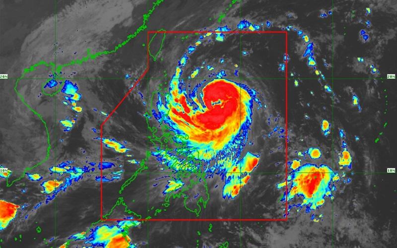
Leon slightly intensifies, moves west northwestward

Over 20 areas remained under Tropical Cyclone Wind Signal (TCWS) No. 1 as Severe Tropical Storm Leon slightly intensified while moving in the west-northwest direction and as it neared typhoon category, according to the latest Tropical Cyclone Bulletin posted by PAGASA.
As of 4 a.m., the center of Leon was estimated at 645 kilometers east of Tuguegarao City, Cagayan packing maximum sustained winds of 110 kilometers per hour near the center, gustiness of up to 135 kph, and central pressure of 975 hPa.
Leon is moving west northwestward at the speed of 10 kph with strong to storm-force winds that extend outwards up to 640 km from the center.
"This tropical cyclone is expected to rapidly intensify throughout its passage over the Philippine Sea and may reach typhoon category within the next 12 hours," PAGASA said.
"Furthermore, there is an increasing chance that LEON will reach super typhoon category during its period of closest approach to Batanes."
TCWS No. 1 is hoisted over the following 23 areas:
Luzon
- Batanes
- Cagayan including Babuyan Islands
- Isabela
- Quirino
- Nueva Vizcaya
- Apayao
- Kalinga
- Abra
- Mountain Province
- Ifugao
- Benguet
- Ilocos Norte
- Ilocos Sur
- La Union
- Aurora
- the northern portion of Quezon including Polillo Islands (General Nakar, Infanta, Real)
- Camarines Norte
- the eastern portion of Camarines Sur (Tinambac, Siruma, Goa, Lagonoy, San Jose, Garchitorena, Caramoan, Presentacion, Tigaon, Calabanga, Saglay)
- Catanduanes
- the eastern portion of Albay (Rapu-Rapu, Bacacay, City of Tabaco, Tiwi, Malilipot, Malinao, Santo Domingo, Manito)
- the northeastern portion of Sorsogon (Prieto Diaz, City of Sorsogon, Gubat)
Visayas
- the eastern portion of Northern Samar (San Roque, Pambujan, Catubig, Laoang, Palapag, Gamay, Lapinig, Mapanas, Mondragon)
- the northern portion of Eastern Samar (Jipapad, Arteche, Oras, San Policarpo)
Leon followed Severe Tropical Storm Kristine, which left over a hundred people dead, based on reports received by the National Disaster Risk Reduction and Management Council (NDRRMC). The council, however, said the number has yet to be validated.
Kristine also brought P2.5 billion agricultural damage and P1.5 billion worth of damage to infrastructure.
Weather conditions
Meanwhile, PAGASA said Cagayan Valley, Cordillera Administrative Region, Aurora, Quezon, Camarines Norte, Camarines Sur, and Catanduanes will have rains with gusty winds due to Severe Tropical Storm Leon with the possibility that flash floods or landslides will occur due to heavy to intense rains. Minor to moderate threat to lives and properties due to strong winds.
Ilocos Region, the rest of Bicol Region, MIMAROPA, Western Visayas, Negros Island Region, Northern Samar, and Zamboanga del Norte will have cloudy skies with scattered rains and thunderstorms due to the Trough of Severe Tropical Storm Leon with the possibility that flash floods or landslides will occur due to moderate to at times heavy rains.
Metro Manila and the rest of the country will have partly cloudy to cloudy skies with isolated rain showers or thunderstorms due to localized thunderstorms with the possibility that flash floods or landslides will occur due to severe thunderstorms.
PAGASA expained that the wind signals warn the public of the general wind threat over an area due to the tropical cyclone. Local winds may be slightly stronger/enhanced in coastal and upland/mountainous areas exposed to winds. Winds are less strong in areas sheltered from the prevailing wind direction.
Coastal Water Condition
The wind speed forecast for northern and eastern sections of Northern Luzon is strong moving in the north to northwest direction with rough coastal waters.
Central Luzon and the eastern section of Southern Luzon will experience moderate to strong wind speed moving in the northwest to west direction while coastal waters will be moderate to rough.
The rest of the country will experience moderate to strong wind speed moving in the west to southwest direction with moderate to rough coastal waters.
Furthermore, the wind flow coming towards the circulation of Severe Tropical Storm Leon will also bring gusty conditions (strong to gale-force) over the following localities (especially in coastal and upland areas exposed to winds) outside Wind Signal areas: Bataan, Metro Manila, CALABARZON, MIMAROPA, Bicol Region, Visayas, Dinagat Islands, Surigao del Norte, and Camiguin.
Hazards affecting coastal waters
A Gale Warning is hoisted over the seaboard of Northern Luzon and the eastern seaboards of Central and Southern Luzon.
Sea travel is risky for all types or tonnage of vessels. All mariners must remain in port or, if underway, seek shelter or safe harbor as soon as possible until winds and waves subside.
Track and Intensity Outlook
Severe Tropical Storm Leon is forecast to move generally west northwestward today, then turn northwestward on Wednesday until it makes landfall along the eastern coast of Taiwan on Thursday afternoon or evening.
"After crossing the landmass of Taiwan, Leon will then turn to the northward to north northeastward towards the East China Sea and exit the Philippine Area of Responsibility on Thursday evening or early Friday morning," the weather bureau reported. — BAP/KBK, GMA Integrated News


