

Signal No. 1 in 22 areas as Leon intensifies over PH Sea
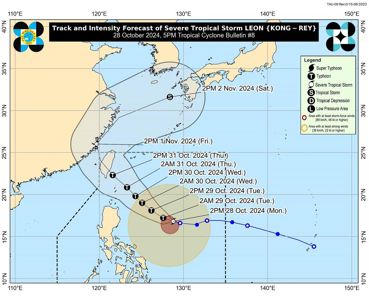
Signal No. 1 is hoisted over 22 areas as Severe Tropical Storm Leon intensified over the Philippine Sea, PAGASA said late Monday afternoon.
In it’s 5 p.m. bulletin, the state weather bureau said the following areas are under Signal No. 1:
- Batanes
- Cagayan including Babuyan Islands
- Isabela
- Quirino
- Nueva Vizcaya
- Apayao
- Kalinga
- Abra
- Mountain Province
- Ifugao
- the northern portion of Benguet (Bakun, Kibungan, Atok, Bokod, Mankayan, Buguias, Kabayan)
- Ilocos Norte
- Ilocos Sur
- La Union
- Aurora
- the northern portion of Quezon including Polillo Islands (General Nakar, Infanta, Real), Camarines Norte
- the eastern portion of Camarines Sur (Tinambac, Siruma, Goa, Lagonoy, San Jose, Garchitorena, Caramoan, Presentacion, Tigaon, Calabanga, Saglay)
- Catanduanes
- the eastern portion of Albay (Rapu-Rapu, Bacacay, City of Tabaco, Tiwi, Malilipot, Malinao, Santo Domingo, Manito)
- the northeastern portion of Sorsogon (Prieto Diaz, City of Sorsogon, Gubat)
- The eastern portion of Northern Samar (San Roque, Pambujan, Catubig, Laoang, Palapag, Gamay, Lapinig, Mapanas, Mondragon)
- the northern portion of Eastern Samar (Jipapad, Arteche, Oras, San Policarpio)
At 4 p.m., Leon was observed 725 km east of Echague, Isabela with maximum sustained winds of 100 km/h near the center and gustiness of up to 125 km/h, moving west northwestward at 15 km/h.
Leaon may become a typhoon within 24 hours and is seen to further strengthen into a super typhoon during its period of closest approach to Batanes.
PAGASA said Signal No. 3 or 4 may be raised over extreme northern Luzon.
“The hoisting of Wind Signal No. 5 is also not ruled out,” PAGASA said.
Leon is also expected to move west northwestward Monday through Tuesday, then turn northwestward until it makes landfall along the eastern coast of Taiwan on Thursday evening or early Friday morning.
It added that strong to gale-force gusts will occur over Zambales, Bataan, Aurora, Metro Manila, CALABARZON, MIMAROPA, Bicol Region, Visayas, Dinagat Islands, Surigao del Norte, and Camiguin.
“After crossing the landmass of Taiwan, LEON will then turn to the northeast towards the East China Sea and exit the Philippine Area of Responsibility on Friday morning or afternoon,” PAGASA said.
The state weather bureau added that there is an increasing possibility of further westward shift in Leon’s track but within the limits of the forecast confidence cone.
As such, a landfall or close approach scenario on Batanes is not ruled out.
“The hoisting of Wind Signal No. 5 is also not ruled out,” PAGASA said.
In it’s weather forecast, PAGASA said the trough of Leon will bring cloudy skies with scattered rains and thunderstorms over Ilocos Region, Rest of Bicol Region, MIMAROPA, Western Visayas, Negros Island Region, and Zamboanga del Norte.
These moderate to at times heavy rains may trigger flash floods or landslides.
Meanwhile, Metro Manila and the rest of the country may see partly cloudy to cloudy skies with isolated rain showers or thunderstorms due to localized thunderstorms.
These severe thunderstorms may cause flash floods or landslides.
State meteorologists said the country will experience moderate to strong wind conditions and moderate to rough coastal water conditions.
Sunrise will be at 5:50 a.m. on Tuesday. — Mariel Celine Serquiña/BM, GMA Integrated News
