

Leon now a severe tropical storm; 12 areas under Signal No. 1
Twelve areas in Luzon are now under Tropical Cyclone Wind Signal Number 1 as Leon (international name: Kong-Rey) intensified into a severe tropical storm, according to weather bureau PAGASA.
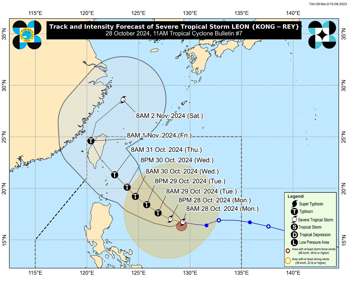
In its latest bulletin late Monday morning, PAGASA said the center of Leon was last seen 735 kilometers east of Casiguran, Aurora or 780 km east of Echague, Isabela moving 20 km/h while packing maximum sustained winds of 95 km/h near the center and gustiness of up to 115 km/h.
Strong winds of at least 39 to 61 km/h may be experienced over the following areas, which are under TCWS No. 1, within the next 36 hours:
- Batanes
- Cagayan including Babuyan Islands
- Isabela
- Ilocos Norte
- Abra
- Apayao
- Kalinga
- Eastern portion of Mountain Province (Natonin, Paracelis)
- Eastern portion of Ifugao (Aguinaldo, Alfonso Lista)
- Eastern portion of Quirino (Maddela)
- Northern portion of Aurora (Dilasag, Casiguran, Dinalungan)
- Northern portion of Catanduanes (Pandan, Bagamanoc, Panganiban, Viga, Gigmoto)
“Although ang Metro Manila, minimal ang epekto ng Bagyong Leon. But with the expected long weekend at Undas, marami ang babyahe… Pinapayuhan natin na doble ingat lalo na ang mga sasakay ng maliit na bangka. Kung puwede ipagpaliban lalong-lalo na sa areas na may mga signals,” said PAGASA administrator Nathaniel Servando in a press briefing.
(Although Leon has minimal effect over Metro Manila, we’re expecting an influx of passengers due to the long weekend and Undas. We’re advising travelers to take precautions, especially those who would have to ride small seacraft in areas with storm signals.)
Movement
PAGASA said Leon is expected to move west northwestward Monday through Tuesday, then turn northwestward until it makes landfall along the eastern coast of Taiwan on Thursday evening or early Friday morning.
After crossing the landmass of Taiwan, Leon will then turn to the northeast towards the East China Sea and exit the Philippine Area of Responsibility (PAR) on Friday morning or afternoon.
According to PAGASA, there is an increasing possibility of further westward shift in Leon’s track but within the limits of the forecast confidence cone.
As such, a landfall or close approach scenario on Batanes is not ruled out, the state weather bureau said.
Leon is also expected to rapidly intensify and reach typhoon category within 24 hours. Further, there is an increasing chance it may strengthen into a super typhoon during its period of closest approach to Batanes.
Meanwhile, PAGASA said heavy to intense rains (100 to 200 mm) may be experienced over Antique due to the trough of Leon. Moderate to heavy rains (50 to 100mm) may prevail over Cagayan, Occidental Mindoro, Negros Occidental, and Palawan. —KBK, GMA Integrated News
