

Leon continues westward move over Philippine Sea, to intensify next 24 hrs
While it remains far from the Philippine landmass, Tropical Storm Leon (international name: Kong-Rey) on late Sunday morning continued to move westward over the Philippine Sea and may gradually intensify in the next 24 hours, according to PAGASA.
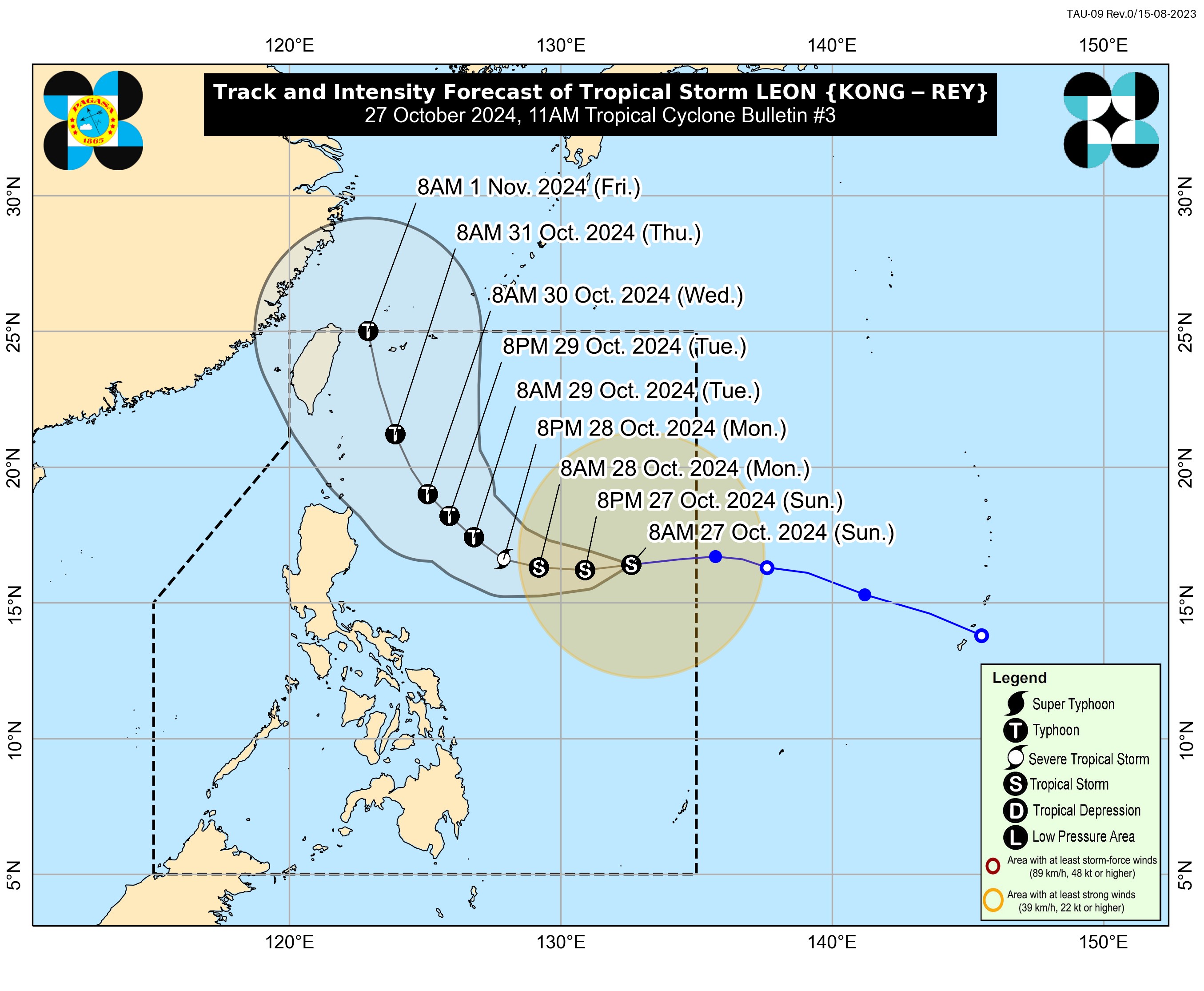
Based on its 11 a.m. bulletin, the state weather bureau said the center of Leon was estimated at 1,075 km east of Central Luzon.
It has a maximum sustained winds of 65 km/h near the center, gustiness of up to 80 km/h, and central pressure of 994 hPa.
It was also moving westward at 30 km/h, and has strong to gale-force winds that extend outwards up to 560 km from the center.
No wind signal is currently in effect as of posting time.
According to PAGASA, the outer rainbands of Leon may affect extreme Northern Luzon depending on how close it will be during its north northwestward movement over the Philippine Sea.
The tropical storm may also continue to influence the southwesterly wind flow initially triggered by Tropical Storm Trami, formerly Kristine, which may affect the Visayas, Mindanao, and the western section of Southern Luzon.
Tropical Cyclone Wind Signal No. 1 may be hoisted over portions of Cagayan Valley and the northeastern portion of Bicol Region by Sunday night or Monday.
The highest wind signal which may be raised during the occurrence of Leon is Wind Signal No. 2, said PAGASA.
Track, intensity
Leon is expected to gradually intensify in the next 24 hours and may reach severe tropical storm category on Monday and typhoon category on Tuesday. This tropical cyclone may also undergo rapid intensification.
It is also seen to move westward on Sunday before moving generally northwestward from Monday to Tuesday, then north northwestward on Wednesday and Thursday.
Based on the track forecast, Leon remains far from the Philippine landmass and may pass very close or make landfall over the southwestern portion of the Ryukyu Islands in Japan.
However, PAGASA said the track forecast may still shift further westward but within the limit of the forecast confidence cone, especially on the day 4 and day 5 of the forecast track.
Wind flow, coastal watersThe wind flow coming towards the circulation of Leon will also bring gusty conditions (strong to gale-force) over the following areas:
- Sunday: Palawan, Romblon, Catanduanes, Sorsogon, Masbate, most of Visayas, Dinagat Islands, Surigao del Norte, and Camiguin.
- Monday: Batanes, Babuyan Islands, Batangas, most of Mimaropa, most of Bicol Region, Visayas, most of Northern Mindanao, and most of Caraga Region.
- Tuesday: Aurora, Metro Manila, Calabarzon, Mimaropa, Bicol Region, Visayas, Dinagat Islands, Surigao del Norte, and Camiguin.
Meanwhile, PAGASA said that up to moderate to rough seas may be experienced over the following coastal waters:
- Up to 3.0 meters: The western seaboard of Luzon
- Up to 2.5 meters: The northern and eastern seaboards of northern Luzon; the northern and eastern seaboards of Catanduanes; the northeastern seaboard of Northern Samar; and the northeastern seaboard of Eastern Samar.
- Up to 2.0 meters: The remaining seaboards of Luzon; the seaboards of Visayas; and the eastern and southern seaboards of Mindanao.
Crews of motor bancas and similarly-sized vessels are thus advised to take precautionary measures while venturing out to sea and avoid navigation under these conditions, if possible. —Giselle Ombay/RF, GMA Integrated News
