

Leon moves over Philippine Sea; Signal No. 1 may be raised tonight
Tropical Storm Leon (international name: Kong-Rey) maintained its strength as it continued to move westward over the Philippine Sea on Sunday morning, PAGASA said in its bulletin.
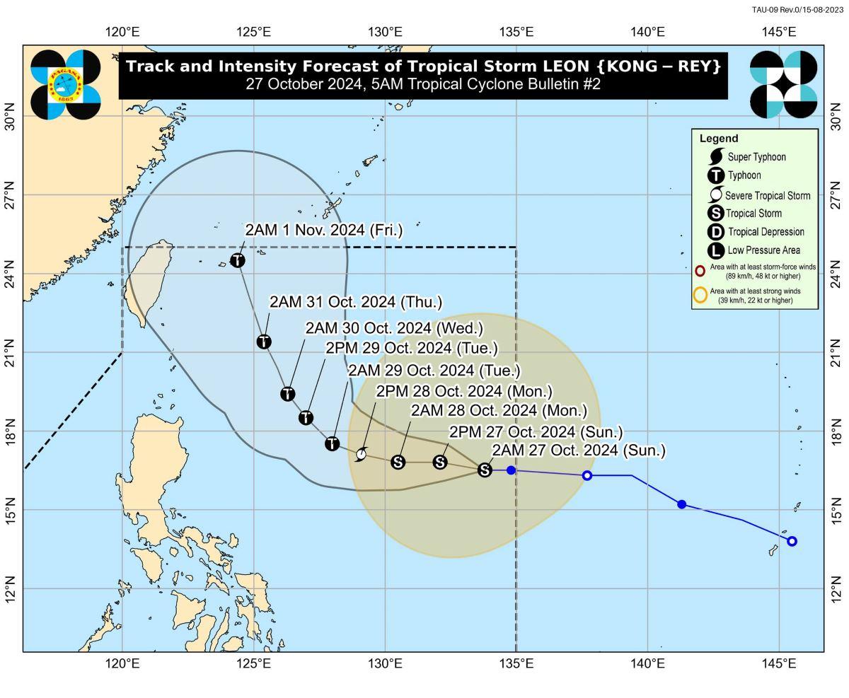
At 4 a.m., the center of Leon was estimated to be located at 1,195 km east of Central Luzon.
Leon has maximum sustained winds of 65 km/h near the center, gustiness of up to 80 km/h, and central pressure of 994 hPa.
The tropical storm is moving westward at 20 km/h.
From its center, strong to gale-force winds are extending outwards up to 640 km.
PAGASA said it did not raise any Tropical Cyclone Wind Signal yet but TCWS No. 1 may be raised over parts of Cagayan Valley and the northeastern portion of Bicol Region on Sunday night.
The highest TCWS that may be raised is TCWS No. 2 during the occurrence of Leon but this depends on the storm's track.
The storm is not seen to directly affect the country's weather condition within the forecast period, but its outer rainbands may affect Extreme Northern Luzon depending on how close it will be during its recurvature over the Philippine Sea. It is forecast to remain far from the Philippine landmass though during the forecast period.
Leon may also continue to influence the southwesterly windflow that may affect the western section of Southern Luzon, Visayas, and Mindanao in the next few days. This southwesterly windflow was initially triggered by Severe Tropical Storm Trami (formerly known as Kristine when it was inside the Philippine Area of Responsibility).
Strong to gale-force gusts may be felt in the following areas, especially in coastal and upland areas exposed to winds:
Sunday, Oct. 27: Catanduanes, Northern Samar, Eastern Samar, and Dinagat Islands
Monday, Oct. 28: Northern Samar, Romblon, Masbate including Burias and Ticao Islands, the northern portion of Antique including Caluya Islands, Capiz, the southern portion of Negros Oriental, Sqiuijor, the southern portion of Bohol, Southern Leyte, Dinagat Islands, Surigao del Norte, Agusan Del Norte. Camiguin, Misamis Oriental, Misamis Occidental, Sarangani, the southern portion of Davao del Sur, and the southern portion of Davao Oriental.
Tuesday, Oct. 29: Batangas, the northern portion of Oriental Mindoro, the northern portion of Camarines Norte, the northern portion of Camarines Sur, the northern portion of Catanduanes, Northern Samar, Romblon, Masbate including Burias and Ticao Islands, the northern portion of Antique including Caluya Islands, Capiz, the southern portion of Negros Oriental, Siquijor, the southern portion of Bohol, Southern Leyte, Dinagat Islands, and Surigao del Norte.
Coastal waters
Moderate seas may be expected in the next 24 hours over:
- the western seaboard of Luzon (up to 3.0 m);
- the northern and eastern seaboards of Northern Luzon (up to 2.5 m);
- the northern and eastern seaboards of Catanduanes (up to 2.5 m);
- the northeastern seaboard of Northern Samar (up to 2.5 m);
- the northeastern seaboard of Eastern Samar (up to 2.5 m);
- the remaining seaboards of Luzon (up to 2.0 m);
- the seaboards of Visayas (up to 2.0 m); and
- the eastern and southern seaboards of Mindanao (up to 2.0 m).
"Mariners of motorbancas and similarly-sized vessels are advised to take precautionary measures while venturing out to sea and, if possible, avoid navigation under these conditions," PAGASA said.
Track, intensity outlook
Leon is expected to move westward until Monday early morning, then turn west northwestward starting Monday morning to Tuesday early morning.
From there, it will turn northwestward to north northwestward then possibly make landfall over Ryukyu Islands in Okinawa, Japan on Friday early morning.
"However, the track forecast may still shift further westward but within the limit of the forecast confidence cone, especially on the day-4 and day-5 of the forecast track," PAGASA said.
Leon is seen to intensify in the next 24 hours and be a severe tropical storm by early morning of Monday, then develop into a typhoon on Monday evening of early Tuesday morning.
PAGASA advised the public and disaster risk reduction and management offices concerned to take the necessary measures to protect life and property.
The next bulletin will be issued by PAGASA at 11 a.m. —KG, GMA Integrated News
