

PAGASA: Storm on track to enter PAR, may become typhoon on Monday
Tropical Storm Kong-Rey maintained strength as it continued to march closer to the Philippine Area of Responsibility (PAR), with a potential of becoming a typhoon on Monday, state weather bureau PAGASA said.
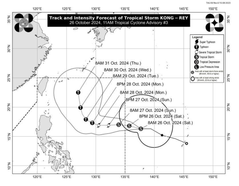
In its 11 a.m. Saturday bulletin, PAGASA said Kong-Rey was spotted 1,630 kms east of Central Luzon, which was still outside of the PAR. Upon entering the PAR, however, the weather disturbance will be named "Leon."
Kong-Rey was moving westward at 30 kph. It packed maximum sustained winds of 65 kph near the center and gusts of up to 80 kph.
Strong to gale-force winds extended outwards up to 630 kms from the center.
Over the weekend, Kong-Rey is forecast to move westward, then turn north northwestward.
It is predicted to enter PAR as a tropical storm on Saturday night or early Sunday morning.
"This tropical cyclone is expected to gradually intensify and may reach severe tropical storm category on Sunday. Furthermore, it may also reach typhoon category on Monday," PAGASA said.
Although the path of the weather disturbance currently remained far from the Philippine landmass, PAGASA said "the track forecast may still shift within the limit of the forecast confidence cone, especially on the day-4 and day-5 of the track forecast."
Based on PAGASA's current track and intensity forecast, Kong-Rey's center would be located 940 kms east of northern Luzon at 8 a.m. Sunday. By this time, it would have entered PAR as a severe tropical storm.
Come Tuesday morning, it would be 695 kms east of Tuguegarao City; 570 kms east of Basco, Batanes on Wednesday morning; and 565 kms east northeast of Itbayat, Batanes by Thursday morning or the eve of observance of Undas or All Saints' Day.
"Depending on how close it will be during its recurvature over the Philippine Sea, the outer rainbands of KONG-REY may also affect Extreme Northern Luzon. Furthermore, it may also continue to influence the Southwesterly Windflow initially triggered by Severe Tropical Storm KRISTINE, which may affect the western section of Southern Luzon, Visayas, and Mindanao in the coming days," PAGASA said.
Moderate to rough sea conditions over the northern and eastern seaboards of Luzon and the eastern seaboard of Visayas were expected due to the approaching storm. Mariners were advised to take precautionary measures. — VDV, GMA Integrated News
