

PAGASA: 23 areas under Signal No. 1 as Kristine exits PAR
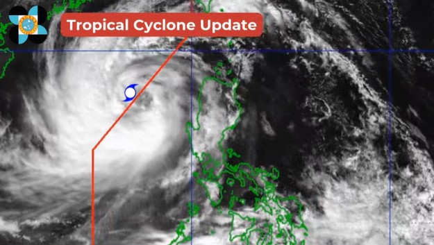
Severe Tropical Storm Kristine (international name: Trami) exited the Philippine area of responsibility (PAR) on Friday afternoon, according to state weather bureau PAGASA.
"At 2:00 PM today, Severe Tropical Storm #KristinePH exited the Philippine Area of Responsibility. All are advised to monitor updates from DOST-PAGASA," PAGASA said on Facebook.
In its 5 p.m. bulletin, PAGASA said that Kristine continues to accelerate outside of PAR.
The center of the storm was spotted 410 kilometers west of Sinait, Ilocos Sur. It also has maximum sustained winds of 95 kilometers per hour near the center, and gustiness of up to 115 kph.
Kristine is moving west northwestward at 30 kph, the state meteorologists added.
Tropical Cyclone Wind Signal No. 1 is hoisted in the following areas:
- Ilocos Norte
- Ilocos Sur
- La Union
- Pangasinan
- Apayao
- Kalinga
- Abra
- Mountain Province
- Ifugao
- Benguet
- Cagayan including Babuyan Islands
- Isabela
- Quirino
- Nueva Vizcaya
- Nueva Ecija
- Tarlac
- Zambales
- Bataan
- Pampanga
- Bulacan
- Metro Manila
- the northern portion of Rizal (Cainta, Rodriguez, San Mateo, City of Antipolo, Taytay)
- the northern portion of Cavite (Ternate, Naic, Tanza, Rosario, Bacoor City, Kawit, Noveleta, Cavite City, City of General Trias, Imus City, Maragondon)
However, PAGASA has said that Kristine may make a U-turn or "loop" over the West Philippine Sea (WPS) in the coming days.
“Kristine will continue moving westward over the West Philippine Sea until tomorrow, loop counterclockwise on Sunday and Monday, then move eastward for the remainder of the forecast period,” the state weather bureau said in its latest update.
“However, this scenario heavily depends on the behavior of the tropical cyclone east of the PAR region and the behavior of other synoptic weather systems surrounding KRISTINE while over the West Philippine Sea.”
Meteorologists refer to the interaction of two tropical cyclones as the Fujiwhara effect.
According to the US National Weather Service, when two tropical cyclones "spinning in the same direction pass close enough to each other, they begin an intense dance around their common center."
The Hong Kong Observatory said that the two storms should be roughly 1,350 kms. apart for this to occur. —with a report from Vince Angelo Ferreras/VDV/AOL, GMA Integrated News
