

Signal No. 2 up over 18 Luzon areas as Kristine nears PAR exit
Tropical Cyclone Wind Signal No. 2 is hoisted in 18 areas in Luzon as Severe Tropical Storm Kristine nears exiting the Philippine area of responsibility (PAR), state weather bureau PAGASA said on Friday.
In its 11 a.m. bulletin, PAGASA said the following Luzon areas are under TCWS No. 2:
- The northwestern portion of mainland Cagayan (Santa Praxedes, Claveria, Sanchez-Mira, Abulug, Pamplona)
- The Babuyan Islands
- Nueva Vizcaya
- Apayao
- Abra
- Kalinga
- Mountain Province
- Ifugao
- Benguet
- Ilocos Norte
- Ilocos Sur
- La Union
- Pangasinan
- Nueva Ecija
- Tarlac
- Pampanga
- Zambales
- The northern portion of Bataan (Morong, Hermosa, Dinalupihan, Bagac, Orani, Samal, Abucay, City of Balanga)
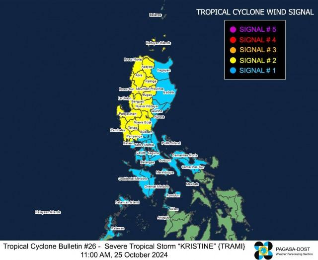
Meanwhile, TCWS No. 1 is raised over the following areas in Luzon and the Visayas:
Luzon
- Batanes
- the rest of mainland Cagayan
- Isabela
- Quirino
- Aurora
- Bulacan
- the rest of Bataan
- Metro Manila
- Cavite
- Batangas
- Laguna
- Rizal
- Quezon
- Occidental Mindoro
- Oriental Mindoro
- Marinduque
- Romblon
- The northern portion of Palawan (El Nido, Taytay, San Vicente, Dumaran, Araceli) including Calamian, Cuyo, and Kalayaan Islands
- Camarines Norte
- Camarines Sur
- Burias Islan
Visayas
- The northern portion of Aklan (Buruanga, Malay, Nabas, Ibajay)
- The northern portion of Antique (Libertad, Pandan) including Caluya Islands
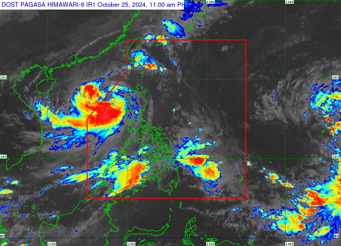
Kristine was last spotted 255 kilometers west northwest of Bacnotan, La Union or 255 kilometers west southwest of Sinait, Ilocos Sur, moving west northwestward at 15 km per hour (kph).
The severe tropical storm was packing maximum sustained winds of 95 kph near the center and gustiness of up to 115 kph.
Impact
Five people were reportedly killed in Agoncillo, Batangas during the onslaught of Kristine, according to Bam Alegre's report on GMA Integrated News’ Unang Balita. The victims died after getting buried under the muddy flood and debris in Barangays Subic Ilaya, Subic Ibaba, and Panhulan.
Several vehicles were stuck in floodwaters while communication lines interrupted in the area.
In Cavite, over 1,700 families have evacuated as Kristine caused floods in many roads in the province, according to a report of Jhomer Apresto on Unang Balita.
The most affected areas are in Noveleta, Kawit, and Bacoor, the provincial government said.
In Pilila, Rizal, the livelihood of fishermen were affected as the water in Laguna De Bay swelled amid the heavy rains. They were forced to take their boats to higher locations to prevent them from getting drifted by strong winds.
The roofs of some houses in the town were also damaged.
In Ilocos Norte, Kristine damaged rice and corn fields worth P300,000 in Laoag City, according to a report of JP Soriano on Unang Balita. The cost of damage was lower because some farmers harvested early ahead of Kristine’s impact.
A total of 1,607 people or 534 families have evacuated from their homes as Kristine partially destroyed 45 houses.
Exit
According to PAGASA, Kristine is expected to exit PAR on Friday afternoon or evening.
“In the extended outlook, there is a developing forecast situation wherein KRISTINE will continue moving westward over the West Philippine Sea until tomorrow, loop counterclockwise on Sunday and Monday, then move eastward for the remainder of the forecast period.
“However, this scenario heavily depends on the behavior of the tropical cyclone east of the PAR region and the behavior of other synoptic weather systems surrounding KRISTINE while over the West Philippine Sea,” it added.
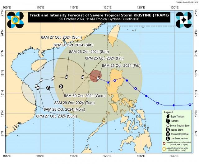
Kristine may gradually intensify over the West Philippine Sea and its upgrade into a typhoon is not ruled out, according to PAGASA.
“While it is likely that the tropical cyclone will remain a severe tropical storm in the next five days, the chance for it to be upgraded into a typhoon is not ruled out,” PAGASA said.
“However, a weakening trend is expected by early next week due to a possible surge of northeasterly wind flow over the West Philippine Sea,” it added.
—VAL, GMA Integrated News