

Kristine maintains strength, accelerates over sea west of N. Luzon
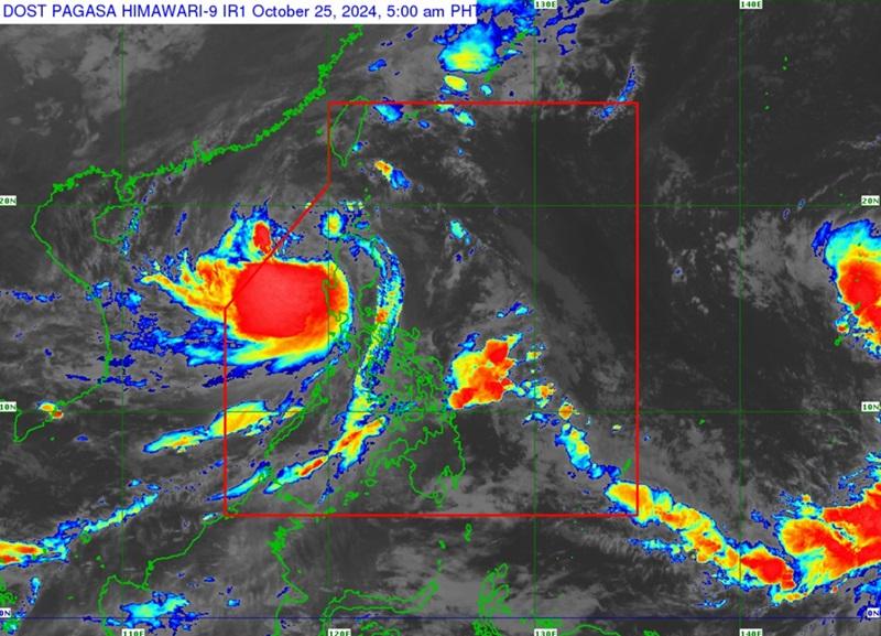
Severe Tropical Storm Kristine maintains its strength as it accelerates west northwestward over the sea west of Northern Luzon, according to the latest Tropical Cyclone Bulletin posted by PAGASA.
The center of the eye of Severe Tropical Storm Kristine was estimated at 125 kilometers west northwest of Bacnotan, La Union packing maximum sustained winds of 95 kilometers per hour near the center, gustiness of up to 115 kph and moving west northwestward at 25 kph.
Tropical Cyclone Wind Signal (TCWS) no. 2 is hoisted over the following areas:
- Cagayan including Babuyan Islands
- Isabela
- Quirino
- Nueva Vizcaya
- Apayao
- Kalinga
- Abra
- Ifugao
- Mountain Province
- Benguet
- Ilocos Norte
- Ilocos Sur
- La Union
- Pangasinan
- Aurora
- Nueva Ecija
- Tarlac
- Zambales
- Bataan
- Pampanga
- Bulacan
- Metro Manila
- the northern portion of Cavite (Ternate, Maragondon, Naic, Tanza, City of General Trias, Rosario, Cavite City, Noveleta, Kawit, Imus City, Bacoor City)
- the northern portion of Rizal (Cainta, Taytay, Angono, San Mateo, Rodriguez, Tanay, City of Antipolo, Baras, Teresa, Morong)
- the northern portion of mainland Quezon (General Nakar)
Tropical Cyclone Wind Signal no. 1 is hoisted over the following areas:
Luzon
- Batanes
- the rest of Rizal
- the rest of Cavite
- Batangas
- Laguna
- the rest of Quezon including Polillo Islands
- Occidental Mindoro including Lubang Islands
- Oriental Mindoro
- Marinduque
- Romblon
- the northern portion of mainland Palawan (El Nido, Taytay, Araceli, Dumaran, San Vicente) including Calamian, Cuyo, and, Kalayaan Islands
- Camarines Norte
- Camarines Sur
- Catanduanes
- Albay
- the northern and central portions of Sorsogon (Castilla, Magallanes, Pilar, Casiguran, Donsol, Juban, Gubat, City of Sorsogon, Prieto Diaz, Bulan)
- the northern and central portions of Masbate (City of Masbate, Uson, Dimasalang, Mobo, Cawayan, Aroroy, Balud, Mandaon, Milagros, Baleno) including Ticao and Burias Islands
Visayas
- Aklan
- Capiz
- Antique including Caluya Islands
- Iloilo
- Bantayan Islands
- the western portion of Northern Samar (Rosario, Biri, San Isidro, Capul, San Vicente, Victoria, Lavezares, San Antonio, San Jose, Allen, Bobon)
- the northern portion of Samar (Tagapul-An)
Heavy Rainfall Outlook
Moderate to heavy rainfall (50 to 100 mm) is forecasted over Pangasinan, La Union, Benguet, Tarlac, Pampanga, Zambales and Bataan
Metro Manila, Ilocos Region, Cordillera Administrative Region, Cagayan Valley, and Central Luzon will have stormy weather due to Severe Tropical Storm Kristine with the possibility that flooding or landslides will occur due to heavy to intense rains. Minor to moderate threat to lives and properties due to strong winds.
The rest of Luzon will have rains with gusty winds due to Severe Tropical Storm Kristine with the possibility that flooding or landslides will occur due to moderate to heavy with at times intense rains. Minimal to minor threat to lives and properties due to strong winds.
Visayas will have cloudy skies with scattered rains and thunderstorms due to the trough of Severe Tropical Storm Kristine with the possibility that flooding or landslides will occur due to moderate to at times heavy rains.
Mindanao will have partly cloudy to cloudy skies with isolated rain showers or thunderstorms due to the trough of Severe Tropical Storm Kristine with the possibility that flooding or landslides will occur during severe thunderstorms.
Severe Winds
The wind signals warn the public of the general wind threat over an area due to the tropical cyclone. Local winds may be slightly stronger/enhanced in coastal and upland/mountainous areas exposed to winds. Winds are less strong in areas sheltered from the prevailing wind direction.
Furthermore, the wind flow coming towards the circulation of Kristine, the northeasterly windflow, and southwesterly windflow will also bring strong to gale-force gusts over the following areas (especially in coastal and upland areas exposed to winds): MIMAROPA, Bicol Region, Visayas, Dinagat Islands, Surigao del Norte, Northern Mindanao, Zamboanga Peninsula, BARMM, SOCCSKSARGEN, and Davao Region.
Coastal Inundation
There is a minimal to moderate risk of storm surge with peak heights of around 1.0 to 2.0 m above normal tide levels in the next 48 hours over the low-lying or exposed coastal localities of Ilocos Sur, La Union, Pangasinan, and Zambales.
Hazards affecting coastal areas
A Gale Warning is hoisted over the seaboards of Luzon and the western seaboard of Visayas.
The wind speed forecast for Northern and Central Luzon is strong moving in the southwest to southeast direction with rough coastal waters.
Visayas and the rest of Luzon will have moderate to strong wind speed moving in the southwest to south direction and moderate to rough coastal waters.
Mindanao will have moderate to strong wind speed moving southwestward while coastal waters will be moderate to rough.
Mariners are advised to take precautionary measures while venturing out to sea and, if possible, avoid navigation under these conditions.
Track and Intensity outlook
Severe Tropical Storm Kristine is forecast to move west northwestward to westward over the next 48 hours and exit the Philippine Area of Responsibility (PAR) region by Friday afternoon.
The weather bureau, in its extended outlook, said there is a developing forecast situation wherein Kristine will be looping over the West Philippine Sea on Sunday and Monday and move generally eastward towards the general direction of the PAR region.
However, this scenario heavily depends on the behavior of the tropical cyclone east of the PAR region.
Meanwhile, the tropical depression outside the PAR is located 2,440 kilometers east of Eastern Visayas packing maximum sustaines winds of 55 kilometers per hour near the center, gustiness of up to 70 kph, and moving northward at 25 kph.
PAGASA said a Tropical Cyclone Advisory will be issued once the tropical cyclone (10d) enters the longitude of 145°E.
Additionally, a Low Pressure Area (LPA 10e) is being monitored within the PAGASA monitoring domain. The potential for LPA (10e) to develop into a Tropical Depression within the next 24 hours still remains low.
Sunrise will be at 5:50 a.m., sunset at 5:31 p.m. — BAP, GMA Integrated News
