

Kristine moves northwestward, heavy rains expected over some Luzon areas
Severe Tropical Storm Kristine turns northwestward over the sea west of the Ilocos Region with heavy rainfall expected over some areas in Luzon early Friday morning, according to the latest Tropical Cyclone Bulletin posted by PAGASA.
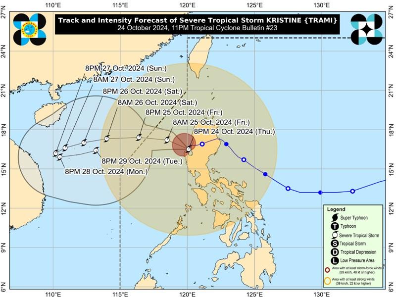
The center of the eye of Severe Tropical Storm Kristine was estimated at 115 kilometers west of Bacnotan, La Union packing maximum sustained winds of 95 kilometers per hour near the center, gustiness of up to 115 kph, ang moving northeastward at 10 kph.
Tropical Cyclone Wind Signal (TCWS) no. 2 is hoisted over the following areas:
- Cagayan including Babuyan Islands
- Isabela
- Quirino
- Nueva Vizcaya
- Apayao
- Kalinga
- Abra
- Ifugao
- Mountain Province
- Benguet
- Ilocos Norte
- Ilocos Sur
- La Union
- Pangasinan
- Aurora
- Nueva Ecija
- Tarlac
- Zambales
- Bataan
- Pampanga
- Bulacan
- Metro Manila
- the northern portion of Cavite (Ternate, Maragondon, Naic, Tanza, City of General Trias, Rosario, Cavite City, Noveleta, Kawit, Imus City, Bacoor City)
- the northern portion of Rizal (Cainta, Taytay, Angono, San Mateo, Rodriguez, Tanay, City of Antipolo, Baras, Teresa, Morong)
- the northern portion of mainland Quezon (General Nakar)
Tropical Cyclone Wind Signal no. 1 is hoisted over the following areas:
Luzon
- Batanes
- the rest of Rizal
- the rest of Cavite
- Batangas
- Laguna
- the rest of Quezon
- Occidental Mindoro
- Oriental Mindoro including Lubang Islands
- Marinduque
- Romblon
- the northern portion of mainland Palawan (El Nido, Taytay, Araceli, San Vicente, Dumaran, Roxas) including Calamian, Cuyo, and, Kalayaan Islands
- Camarines Norte
- Camarines Sur
- Catanduanes
- Albay
- Sorsogon
- Masbate including Ticao and Burias Islands
Visayas
- Aklan
- Capiz
- Antique including Caluya Islands
- Iloilo
- Bantayan Islands
- the western portion of Northern Samar (Rosario, Biri, San Isidro, Capul, San Vicente, Victoria, Lavezares, San Antonio, San Jose, Allen, Bobon)
- the northern portion of Samar (Tagapul-An)
Heavy Rainfall Outlook
Heavy to intense rains (100 to 200mm) expected over the following areas: Pangasinan, La Union, Zambales, Bataan, Cavite, Batangas
Moderate to heavy rains (50 to 100mm) expected over the following areas: Metro Manila, Benguet, Occidental Mindoro, the rest of CALABARZON, Tarlac, Pampanga, Bulacan
Severe Winds
The wind signals warn the public of the general wind threat over an area due to the tropical cyclone. Local winds may be slightly stronger/enhanced in coastal and upland/mountainous areas exposed to winds. Winds are less strong in areas sheltered from the prevailing wind direction.
The wind flow coming towards the circulation of Kistine, the northeasterly windflow, and southwesterly windflow will also bring strong to gale-force gusts over the following areas (especially in coastal and upland areas exposed to winds): MIMAROPA, Bicol Region, Visayas, Dinagat Islands, Surigao del Norte, Northern Mindanao, Zamboanga Peninsula, BARMM, SOCCSKSARGEN, and Davao Region.
Coastal Inundation
PAGASA also reported that there is a minimal to moderate risk of storm surge with peak heights of around 1.0 to 2.0 m above normal tide levels in the next 48 hours over the low-lying or exposed coastal localities of Ilocos Sur, La Union, Pangasinan, and Zambales.
Hazards affecting coastal waters
A Gale Warning is hoisted over the seaboards of Luzon and the western and central seaboards of Visayas.
24-Hour Sea Condition Outlook
Up to very rough or high seas over the following coastal waters:
Up to 7.0 m: The seaboards of Zambales and Pangasinan
Up to 6.0 m: The remaining seaboard of Ilocos Region; the seaboards of Cagayan Valley and Bataan
Up to 5.0 m: The western seaboards of Occidental Mindoro and Calamian Islands; the seaboard of northern Aurora
Up to 4.5 m: The western seaboards of northern Palawan including Kalayaan Islands
Sea travel is risky for all types or tonnage of vessels. All mariners must remain in port or, if underway, seek shelter or safe harbor as soon as possible until winds and waves subside.
Up to rough seas over the following coastal waters:
Up to 4.0 m: The southern seaboard of Quezon, the remaining seaboard of MIMAROPA, the western and southern seaboards of Negros Occidental and Negros Oriental.
Up to 3.5 m: The remaining seaboard of Aurora, the seaboards of northern Quezon including Polillo Islands, Camarines Norte, and Catanduanes; the northern and eastern seaboards of Camarines Sur.
Up to 3.0 m: The remaining seaboards of Luzon and Visayas.
Mariners of small seacrafts, including all types of motorbancas, are advised not to venture out to sea under these conditions, especially if inexperienced or operating ill-equipped vessels.
Up to moderate seas over the following coastal waters:
Up to 2.5 m: The remaining seaboards of the country.
Mariners of motorbancas and similarly-sized vessels are advised to take precautionary measures while venturing out to sea and, if possible, avoid navigation under these conditions.
Track and Intensity outlook
Kristine is forecast to move westward over the next 12 hours and exit the Philippine Area of Responsibility (PAR) region by Friday afternoon.
"In the extended outlook, there is a developing forecast situation wherein Kristine will be looping over the West Philippine Sea on Sunday and Monday and move generally eastward towards the general direction of the PAR region. However, this scenario heavily depends on the behavior of the tropical cyclone east of the PAR region," the weather bureau said.
Kristine, however, is forecast to re-intensify as it moves over the West Philippine Sea. While it is likely that the tropical cyclone will remain a severe tropical storm in the next five days, there is chance for it to be upgraded into a typhoon. — BAP, GMA Integrated News
