

PAGASA: 25 areas under Signal No. 2 as Kristine keeps strength
Signal No. 2 was hoisted over 25 areas as Severe Tropical Storm Kristine maintained its strength over Lingayen Gulf, the state weather bureau PAGASA said late Thursday evening.
In its 11 p.m. bulletin, Signal No. 2 was raised over the following areas:
- Cagayan including Babuyan Islands
- Isabela
- Quirino
- Nueva Vizcaya
- Apayao
- Kalinga
- Abra
- Ifugao
- Mountain Province
- Benguet
- Ilocos Norte
- Ilocos Sur
- La Union
- Pangasinan
- Aurora
- Nueva Ecija
- Tarlac
- Zambales
- Bataan
- Pampanga
- Bulacan
- Metro Manila
- the northern portion of Cavite (Ternate, Maragondon, Naic, Tanza, City of General Trias, Rosario, Cavite City, Noveleta, Kawit, Imus City, Bacoor City)
- the northern portion of Rizal (Cainta, Taytay, Angono, San Mateo, Rodriguez, Tanay, City of Antipolo, Baras, Teresa, Morong)
- the northern portion of mainland Quezon (General Nakar)
- Batanes
- the rest of Rizal
- the rest of Cavite
- Batangas
- Laguna
- the rest of Quezon
- Occidental Mindoro
- Oriental Mindoro
- Marinduque
- Romblon
- the northern portion of mainland Palawan (El Nido, Taytay, Araceli, San Vicente, Dumaran, Roxas) including Calamian
- Cuyo
- Kalayaan Islands
- Camarines Norte
- Camarines Sur
- Catanduanes
- Albay
- Sorsogon
- Masbate including Ticao and Burias Islands
- Aklan
- Capiz
- Antique including Caluya Islands
- Iloilo
- Bantayan Islands
- the western portion of Northern Samar (Lope de Vega, Rosario, Biri, San Isidro, Capul, San Vicente, Victoria, Lavezares, San Antonio, Mondragon, San Jose, Catarman, San Roque, Allen, Bobon), the northern portion of Samar (Calbayog City, Tagapul-An)
PAGASA warned of minimal to moderate risk of storm surge with peak heights of around 1.0 to 2.0 m above normal tide levels in the next 48 hours over the low-lying or coastal localities of Ilocos Sur, La Union, Pangasinan, and Zambales.
A gale warning is in effect over the seaboards of Luzon and the western and central seaboards of Visayas.
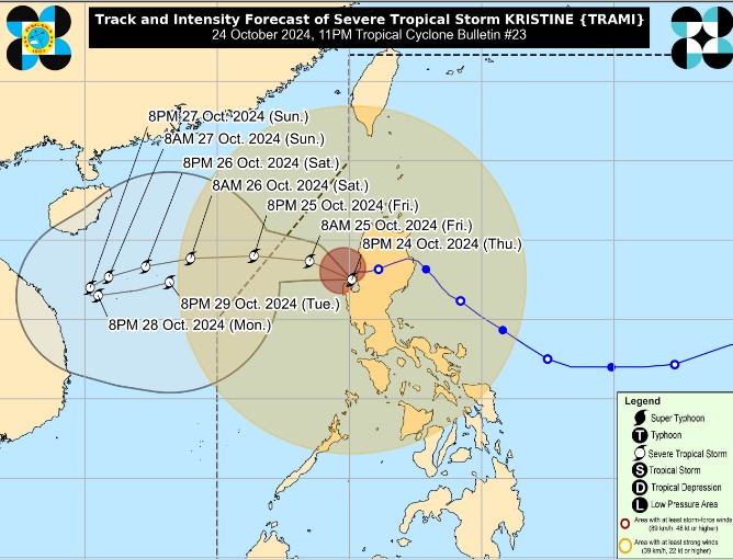
At 10 p.m., Kristine was spotted over the coastal waters of Bolinao, Pangasinan, with maximum sustained winds of 95 kph near the center and gustiness of up to 145 kph, south southwestward slowly.
Kristine is seen to move westward over the next 12 hours and exit the Philippine Area of Responsibility Friday afternoon.
State meteorologists said Kristine would loop over the West Philippine Sea on Sunday and Monday and move eastward or east northwestward towards the general direction of the PAR region.
“Kristine is forecast to re-intensify as it moves over the West Philippine Sea. While it is likely that the tropical cyclone will remain a severe tropical storm in the next five days, the chance for it to be upgraded into a typhoon is not ruled out,” it said.
The low-pressure area east of northeastern Mindanao has developed into a tropical depression outside the Philippine Area of Responsibility.
According to PAGASA's social media post at past 10 p.m., the LPA 2,405 km east of northeastern Mindanao developed into a tropical depression at 8 p.m.
It was spotted with winds of up to 55 kph near the center and gustiness of up to 70 kph. It was moving north-northwest at 35 kph.
Another LPA outside PAR 2,265 km of northeastern Mindanao is being monitored by the PAGASA but is unlikely to develop into a tropical depression in the next 24 hours.—NB, GMA Integrated News
