

Kristine slows down, Signal No. 3 remains over 16 areas
Sixteen areas remained under Tropical Cyclone Wind Signal (TCWS) No. 3 as Severe Tropical Storm Kristine gradually decelerated early Thursday morning while moving northwestward over North Luzon, state weather forecasters PAGASA said.
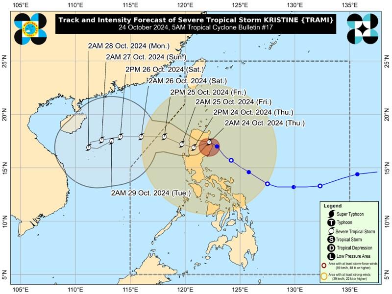
In its 5 a.m. bulletin, PAGASA said the center of Kristine was estimated in the vicinity of Tumauini, Isabela packing maximum sustained winds of 95 kilometers per hour near the center, gustiness of up to 160 km/h, and central pressure of 985 hPa.
Kristine is moving west northwestward at 15 kph strong to storm-force winds extend outwards up to 730 km from the center.
TCWS No. 3 is hoisted over the following areas:
- the southern portion of Cagayan (Peñablanca, Tuguegarao City, Enrile, Solana, Iguig, Tuao)
- Isabela
- Quirino
- Nueva Vizcaya
- Kalinga
- Mountain Province
- Ifugao
- the southern portion of Abra (Malibcong, Licuan-Baay, Sallapadan, Daguioman, Bucloc, Boliney, Tubo, Luba, Manabo, Bucay, Villaviciosa, Pilar, San Isidro, Peñarrubia)
- Benguet
- the northern and central portions of Aurora (Dilasag, Casiguran, Dinalungan, Dipaculao, Maria Aurora, Baler)
- the northern portion of Nueva Ecija (Carranglan, Lupao, San Jose City, Pantabangan, Guimba, Santo Domingo, Talavera, Llanera, Rizal, Bongabon, Talugtug, Science City of Muñoz, Cuyapo, Nampicuan)
- the northern portion of Tarlac (Mayantoc, San Clemente, Camiling, Santa Ignacia, Gerona, Paniqui, Moncada, San Manuel, Anao, Ramos, Pura, Victoria)
- the northern portion of Zambales (Candelaria, Santa Cruz, Masinloc)
- Pangasinan
- La Union
- the central and southern portions of Ilocos Sur (Cervantes, Quirino, Sigay, Suyo, Alilem, Sugpon, Tagudin, Santa Cruz, Salcedo, Gregorio del Pilar, San Emilio, Lidlidda, Burgos, San Esteban, Santiago, Banayoyo, Galimuyod, City of Candon, Santa Lucia, Nagbukel, Santa Maria, Narvacan)
TCWS No.2 is raised over the following areas:
- Ilocos Norte
- the rest of Ilocos Sur
- Apayao
- the rest of Abra
- the rest of Cagayan
- Babuyan Islands
- the rest of Aurora
- the rest of Nueva Ecija
- Bulacan
- the rest of Tarlac
- Pampanga
- the rest of Zambales
- Bataan
- Metro Manila
- Cavite
- Laguna
- Rizal
- Batangas
- the northern and central portions of Quezon (Lucena City, Pagbilao, Infanta, Tiaong, San Antonio, Candelaria, Lucban, Sampaloc, Sariaya, City of Tayabas, Mauban, Dolores, General Nakar, Real) including Polillo Islands, and Lubang Island
TCWS No.1 is hoisted over the following areas:
- Luzon
- Batanes
- the rest of Quezon
- the rest of Occidental Mindoro
- Oriental Mindoro
- Marinduque
- Romblon
- the northern portion of mainland Palawan (El Nido, Taytay, Araceli, San Vicente, Dumaran, Roxas) including Calamian Islands and Cuyo Islands
- Camarines Norte
- Camarines Sur
- Catanduanes
- Albay
- Sorsogon
- Masbate including Ticao and Burias Islands
- Visayas
- Aklan
- Capiz
- Antique including Caluya Islands
- Iloilo
- Guimaras
- the northern portion of Negros Occidental (Pulupandan, Bacolod City, Silay City, City of Talisay, Enrique B. Magalona, Manapla, City of Victorias, Cadiz City, Sagay City, City of Escalante, Toboso, Valladolid, Bago City, Murcia, Salvador Benedicto, Calatrava)
- the northern portion of Cebu (Medellin, Daanbantayan, San Remigio, City of Bogo, Tabuelan, Tabogon) including Bantayan Islands
- Northern Samar
- Samar
- Biliran
- the northern portion of Eastern Samar (Oras, Can-Avid, Maslog, San Policarpo, Taft, Dolores, Jipapad, Arteche, Sulat)
- the northern portion of Leyte (San Isidro, Calubian, San Miguel, Babatngon, Barugo, Tunga, Carigara, Capoocan, Leyte, Villaba, Tabango)
Rainfall Outlook
Metro Manila, Ilocos Region, Cordillera Administrative Region, Cagayan Valley, Central Luzon, and CALABARZON will be stormy due to Severe Tropical Storm Kristine with the possibility that flooding or landslides will occur due to intense to at times torrential rains. Minor to moderate threat to lives and properties due to strong winds.
Western Visayas, the rest of Luzon, Northern Samar, and Samar will have rains with gusty winds also due to the Severe Tropical Storm Kristine with the possibility that flooding or landslides will occur due to moderate to heavy with at times intense rains. Minimal to minor threat to lives and properties due to strong winds.
Zamboanga Peninsula, Lanao del Norte, Lanao del Sur, Misamis Occidental, and the rest of Visayas will have cloudy skies with scattered rains and thunderstorms due to the trough of Severe Tropical Storm Kristine with the possibility that flooding or landslides will occur due to moderate to at times heavy rains
The rest of MindanaoPartly cloudy to cloudy skies with isolated rainshowers or thunderstormsTrough of STS KristinePossible flash floods or landslides during severe thunderstorms.
Severe Winds
The wind signals warn the public of the general wind threat over an area due to the tropical cyclone. Local winds may be slightly stronger/enhanced in coastal and upland/mountainous areas exposed to winds. Winds are less strong in areas sheltered from the prevailing wind direction.
Moderate to significant impacts from storm-force winds are possible within areas under Signal No. 3 while minor to moderate impacts from gale-force winds are possible within any of the localities under Signal No. 2 and minimal to minor impacts from strong winds are possible within any of the areas under Signal No. 1.
Other hazards affecting land areas
The wind flow coming towards the circulation of Kristine and the Northeasterly Windflow will also bring strong to gale-force gusts over the following areas (especially in coastal and upland areas exposed to winds): MIMAROPA, Bicol Region, Visayas, Basilan, Sulu, Tawi-Tawi, Zamboanga del Norte, Lanao del Sur, Northern Mindanao, Dinagat Islands, Surigao del Norte, Davao del Sur, and Davao Oriental.
Coastal Inundation
PAGASA reported that there is a moderate to high risk of life-threatening storm surge up to 3.0 m above normal tide levels in the next 48 hours over the low-lying or exposed coastal localities of Ilocos Norte, Ilocos Sur, La Union, Pangasinan, Cagayan, Isabela, Aurora, Zambales, and Quezon.
Hazards affecting coastal waters
A Gale Warning is hoisted over the seaboards of Luzon and Visayas.
Mariners are advised not to venture out to sea under these conditions, especially if inexperienced or operating ill-equipped vessels.
The wind speed forecast for Northern and Central Luzon is strong moving in the northeast to northwest direction with rough coastal waters.
Visayas and the rest of Luzon will experience strong wind speed moving in the northwest to southwest direction while coastal waters will be rough.
Mindanao will have moderate to strong wind speed moving southwestward with moderate to rough coastal waters.
sunrise will be at 5:49 a.m., sunset at 5:31 p.m.
Track and Intensity outlook
Kristine is forecast to cross Northern Luzon over the next 12 hours and may emerge over the waters west of Ilocos Region this afternoon or evening and then move west northwestward over the West Philippine Sea and exit the Philippine Area of Responsibility (PAR) region on Friday afternoon. — BAP, GMA Integrated News
