

Kristine remains over Divilacan, Quezon; Signal No. 3 now over 16 areas
Kristine has made landfall over Divilacan, Isabela and continues to move northwestward as Signal No. 3 remains over 16 areas, PAGASA reported in its latest Tropical Cyclone Bulletin.
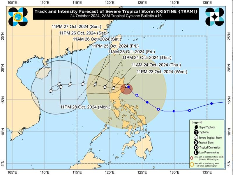
The center of the eye of Severe Tropical Storm Kristine was estimated in the vicinity of Bicobian, Divilacan packing maximum sustained winds of 95 kilometers per hour near the center, gustiness of up to 115 kph, and moving northwestward at 15 kph.
Tropical Cyclone Wind Signal (TCSW) no. 3 is hoisted over the following areas:
- The southern portion of Cagayan (Peñablanca, Tuguegarao City, Enrile, Solana, Iguig, Tuao)
- Isabela
- Quirino
- Nueva Vizcaya
- Kalinga
- Mountain Province
- Ifugao
- the southern portion of Abra (Malibcong, Licuan-Baay, Sallapadan, Daguioman, Bucloc, Boliney, Tubo, Luba, Manabo, Bucay, Villaviciosa, Pilar, San Isidro, Peñarrubia)
- Benguet
- the northern and central portions of Aurora (Dilasag, Casiguran, Dinalungan, Dipaculao, Maria Aurora, Baler)
- the northern portion of Nueva Ecija (Carranglan, Lupao, San Jose City, Pantabangan, Guimba, Santo Domingo, Talavera, Llanera, Rizal, Bongabon, Talugtug, Science City of Muñoz, Cuyapo, Nampicuan)
- the northern portion of Tarlac (Mayantoc, San Clemente, Camiling, Santa Ignacia, Gerona, Paniqui, Moncada, San Manuel, Anao, Ramos, Pura, Victoria)
- the northern portion of Zambales (Candelaria, Santa Cruz, Masinloc)
- Pangasinan
- La Union
- the central and southern portions of Ilocos Sur (Cervantes, Quirino, Sigay, Suyo, Alilem, Sugpon, Tagudin, Santa Cruz, Salcedo, Gregorio del Pilar, San Emilio, Lidlidda, Burgos, San Esteban, Santiago, Banayoyo, Galimuyod, City of Candon, Santa Lucia, Nagbukel, Santa Maria, Narvacan)
TCWS no. 2 is hoisted over the following areas:
- Ilocos Norte
- the rest of Ilocos Sur
- Apayao
- the rest of Abra
- the rest of Cagayan including Babuyan Islands
- the rest of Aurora
- the rest of Nueva Ecija
- Bulacan
- the rest of Tarlac
- Pampanga
- the rest of Zambales
- Bataan
- Metro Manila
- Cavite
- Laguna
- Rizal
- Batangas
- the northern and central portions of Quezon (Pitogo, Lucena City, Calauag, Pagbilao, Infanta, Tiaong, Lopez, Guinayangan, Unisan, General Luna, Plaridel, Quezon, San Antonio, Alabat, Candelaria, Lucban, Sampaloc, Padre Burgos, Sariaya, City of Tayabas, Macalelon, Mauban, Dolores, General Nakar, Perez, Agdangan, Gumaca, Atimonan, Real, Tagkawayan) including Polillo Islands
- the northwestern portion of Camarines Norte (Santa Elena, Vinzons, Labo, Capalonga, Paracale, San Vicente, Talisay, Daet, Jose Panganiban)
TCWS 1 is raised over the following areas:
Luzon
- Batanes
- the rest of Quezon
- Occidental Mindoro including Lubang Islands
- Oriental Mindoro
- Marinduque
- Romblon
- the northern portion of mainland Palawan (El Nido, Taytay, Araceli, San Vicente, Dumaran, Roxas)
- Cuyo Islands
- Calamian Islands
- the rest of Camarines Norte
- Camarines Sur
- Catanduanes
- Albay
- Sorsogon
- Masbate including Ticao and Burias Islands
Visayas
- Aklan
- Capiz
- Antique including Caluya Islands
- Iloilo
- Guimaras
- the northern portion of Negros Occidental (Bago City, Pulupandan, Bacolod City, Murcia, Silay City, City of Talisay, Enrique B. Magalona, Manapla, City of Victorias, Cadiz City, Sagay City, City of Escalante, Toboso, Calatrava, Salvador Benedicto, San Carlos City, La Carlota City, San Enrique, Valladolid)
- the northern portion of Cebu (Daanbantayan, Medellin, San Remigio, Tabogon, City of Bogo, Borbon, Tabuelan, Sogod, Catmon, Tuburan, Carmen, Asturias, Danao City, Balamban)
- Bantayan Islands
- Camotes Islands
- Northern Samar
- Samar
- Biliran
- the northern and eastern portions of Eastern Samar (Oras, Quinapondan, Can-Avid, Lawaan, Maslog, Balangiga, City of Borongan, San Policarpo, Taft, Llorente, Maydolong, Dolores, Giporlos, Jipapad, Arteche, Balangkayan, Sulat, San Julian, General Macarthur, Hernani)
- the northern and central portions of Leyte (Kananga, Tunga, Pastrana, San Miguel, Matag-Ob, Tolosa, Palo, Calubian, Leyte, Mayorga, Julita, Carigara, Babatngon, Dagami, Jaro, San Isidro, Santa Fe, Albuera, Villaba, La Paz, Palompon, Macarthur, Tabontabon, Tanauan, Merida, Ormoc City, Isabel, Javier, Dulag, Capoocan, Alangalang, Burauen, Tabango, Tacloban City, Barugo, City of Baybay)
Severe Winds
The wind signals warn the public of the general wind threat over an area due to the tropical cyclone. Local winds may be slightly stronger/enhanced in coastal and upland/mountainous areas exposed to winds. Winds are less strong in areas sheltered from the prevailing wind direction.
Moderate to significant impacts from storm-force winds are possible within any of the localities where Wind Signal No. 3 is hoisted while minor to moderate impacts from gale-force winds are possible within any of the localities where Wind Signal No. 2 is hoisted with minimal to minor impacts from strong winds are possible within any of the areas under Wind Signal No. 1.
The wind flow coming towards the circulation of Kristine and the Northeasterly Windflow will also bring strong to gale-force gusts over the following areas (especially in coastal and upland areas exposed to winds): MIMAROPA, Bicol Region, Visayas, Basilan, Sulu, Tawi-Tawi, Zamboanga del Norte, Lanao del Sur, Northern Mindanao, Dinagat Islands, Surigao del Norte, Davao del Sur, and Davao Oriental.
Coastal Inundation
PAGASA also reported that there is a moderate to high risk of life-threatening storm surge up to 3.0 m above normal tide levels in the next 48 hours over the low-lying or exposed coastal localities of Ilocos Norte, Ilocos Sur, La Union, Pangasinan, Cagayan, Isabela, Aurora, Zambales, and Quezon.
Hazards affecting coastal waters
A Gale Warning is hoisted over the seaboards of Luzon and Visayas.
The weather bureau said that sea travel is risky and that mariners must remain in port or, if underway, seek shelter or safe harbor as soon as possible until winds and waves subside.
Track and Intensity Outlook
Severe Tropical Storm Kristine is forecast to cross Northern Luzon over the next 12 hours and may emerge over the waters west of Ilocos Region by Thursday afternoon and then move westward or west northwestward over the West Philippine Sea and exit the Philippine Area of Responsibility by Friday afternoon. — BAP, GMA Intgrated News
