

Signal No. 3 in 15 areas as Kristine nears landfall in Isabela
Signal No. 3 has been raised in more areas in Luzon as Severe Tropical Storm Kristine (international name: Trami) is set to make landfall over the province of Isabela, PAGASA said late Wednesday evening.
In its 11 p.m. bulletin, the state weather bureau said Signal No. 3 is hoisted over the following areas:
- Isabela
- Quirino
- Nueva Vizcaya
- Kalinga
- Mountain Province
- Ifugao
- the southern portion of Abra (Malibcong, Licuan-Baay, Sallapadan, Daguioman, Bucloc, Boliney, Tubo, Luba, Manabo, Bucay, Villaviciosa, Pilar, San Isidro, Peñarrubia)
- Benguet
- the northern and central portions of Aurora (Dilasag, Casiguran, Dinalungan, Dipaculao, Maria Aurora, Baler)
- the northern portion of Nueva Ecija (Carranglan, Lupao, San Jose City, Pantabangan, Guimba, Santo Domingo, Talavera, Llanera, Rizal, Bongabon, Talugtug, Science City of Muñoz, Cuyapo, Nampicuan)
- the northern portion of Tarlac (Mayantoc, San Clemente, Camiling, Santa Ignacia, Gerona, Paniqui, Moncada, San Manuel, Anao, Ramos, Pura, Victoria)
- the northern portion of Zambales (Candelaria, Santa Cruz, Masinloc)
- Pangasinan
- La Union
- the central and southern portions of Ilocos Sur (Cervantes, Quirino, Sigay, Suyo, Alilem, Sugpon, Tagudin, Santa Cruz, Salcedo, Gregorio del Pilar, San Emilio, Lidlidda, Burgos, San Esteban, Santiago, Banayoyo, Galimuyod, City of Candon, Santa Lucia, Nagbukel, Santa Maria, Narvacan)
These areas will experience winds greater than 89 kph up to 117 kph in the next 18 hours.
The following areas are under Signal No. 2:
- Ilocos Norte
- the rest of Ilocos Sur
- Apayao
- the rest of Abra
- Cagayan including Babuyan Islands
- the rest of Aurora
- the rest of Nueva Ecija
- Bulacan
- the rest of Tarlac
- Pampanga
- the rest of Zambales
- Bataan
- Metro Manila
- Cavite
- Laguna
- Rizal
- Batangas
- the northern and central portions of Quezon (Pitogo, Lucena City, Calauag, Pagbilao, Infanta, Tiaong, Lopez, Guinayangan, Unisan, General Luna, Plaridel, Quezon, San Antonio, Alabat, Candelaria, Lucban, Sampaloc, Padre Burgos, Sariaya, City of Tayabas, Macalelon, Mauban, Dolores, General Nakar, Perez, Agdangan, Gumaca, Atimonan, Real, Tagkawayan) including Polillo Islands
- the northwestern portion of Camarines Norte (Santa Elena, Vinzons, Labo, Capalonga, Paracale, San Vicente, Talisay, Daet, Jose Panganiban)
Winds of greater than 62 kph and up to 88 kph are expected in these areas within 24 hours.
Signal No. 1 is hoisted over the following areas:
- Batanes
- the rest of Quezon
- Occidental Mindoro including Lubang Islands
- Oriental Mindoro
- Marinduque
- Romblon
- the northern portion of mainland Palawan (El Nido, Taytay, Araceli, San Vicente, Dumaran, Roxas)
- Cuyo Islands
- Calamian Islands
- the rest of Camarines Norte
- Camarines Sur
- Albay
- Sorsogon
- Masbate including Ticao and Burias Islands
- Aklan
- Capiz
- Antique including Caluya Islands
- Iloilo
- Guimaras
- the northern portion of Negros Occidental (Bago City, Pulupandan, Bacolod City, Murcia, Silay City, City of Talisay, Enrique B. Magalona, Manapla, City of Victorias, Cadiz City, Sagay City, City of Escalante, Toboso, Calatrava, Salvador Benedicto, San Carlos City, La Carlota City, San Enrique, Valladolid)
- the northern and portion of Cebu (Daanbantayan, Medellin, San Remigio, Tabogon, City of Bogo, Borbon, Tabuelan, Sogod, Catmon, Tuburan, Carmen, Asturias, Danao City, Balamban) including Bantayan Islands and Camotes Islands
- Northern Samar
- Samar
- Biliran
- the northern and eastern portions of Eastern Samar (Oras, Quinapondan, Can-Avid, Lawaan, Maslog, Balangiga, City of Borongan, San Policarpo, Taft, Llorente, Maydolong, Dolores, Giporlos, Jipapad, Arteche, Balangkayan, Sulat, San Julian, General Macarthur, Hernani)
- the northern and central portions of Leyte (Kananga, Tunga, Pastrana, San Miguel, Matag-Ob, Tolosa, Palo, Calubian, Leyte, Mayorga, Julita, Carigara, Babatngon, Dagami, Jaro, San Isidro, Santa Fe, Albuera, Villaba, La Paz, Palompon, Macarthur, Tabontabon, Tanauan, Merida, Ormoc City, Isabel, Javier, Dulag, Capoocan, Alangalang, Burauen, Tabango, Tacloban City, Barugo, City of Baybay)
Winds of 39-61 kph may be expected in these areas in at least 36 hours, PAGASA said.
Storm surge
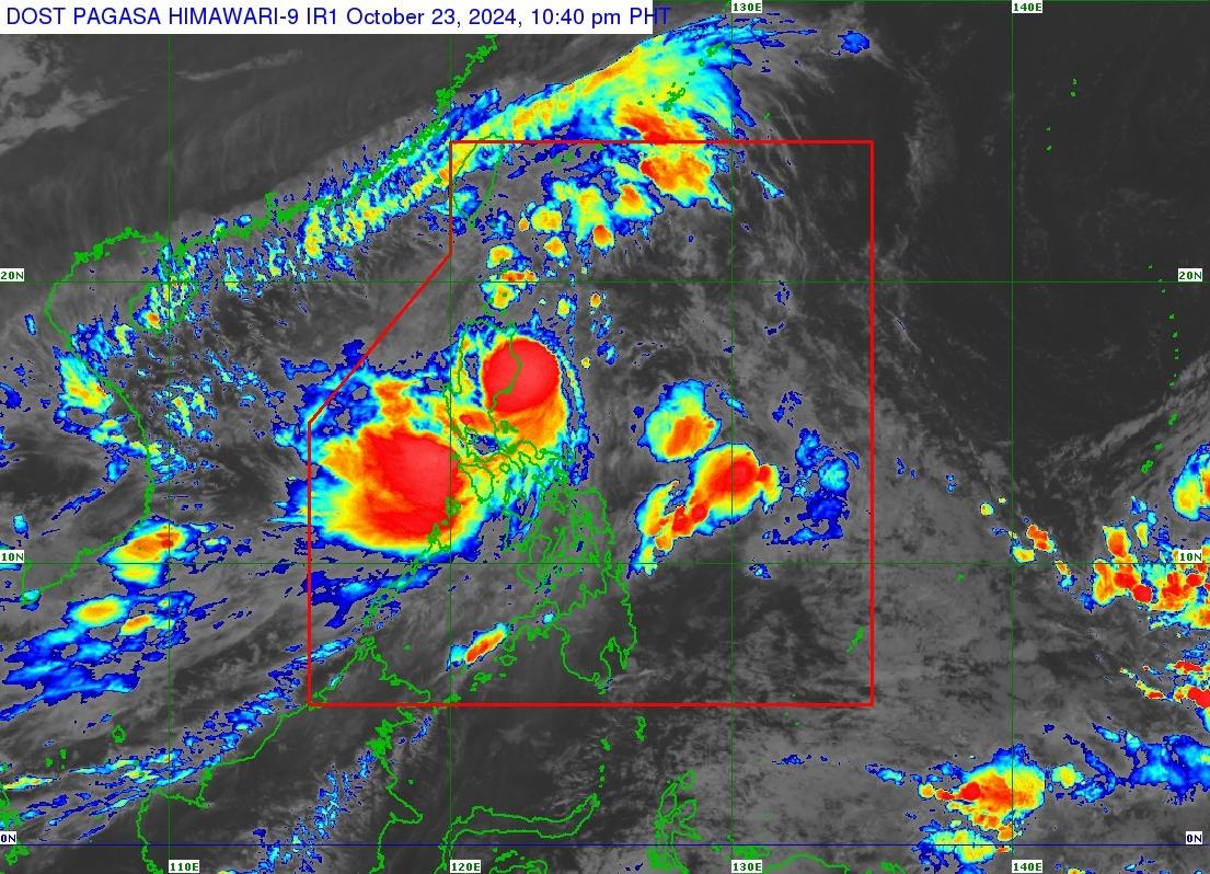
Kristine was located over the coastal waters of Palanan, Isabela with maximum sustained winds of 95 kph and gustiness of up to 130 kph, moving northwestward at 20 kp/h.
PAGASA said strong to gale-force gusts will occur over Mimaropa, Bicol Region, Visayas, Basilan, Sulu, Tawi-Tawi, Zamboanga del Norte, Lanao del Sur, Northern Mindanao, Dinagat Islands, Surigao del Norte, Davao del Sur, and Davao Oriental on Thursday.
PAGASA also reported a moderate to high risk of life-threatening storm surge over the low-lying or exposed coastal localities of Ilocos Norte, Ilocos Sur, La Union, Pangasinan, Cagayan, Isabela, Zambales, Aurora within the next 48 hours.
Kristine is alsoseen to cross northern Luzon over the next 12 hours.
“After traversing the mountainous terrain of Northern Luzon, the center of the severe tropical storm may emerge over the waters west of Ilocos Region tomorrow (24 October) morning or afternoon,” PAGASA said.
“Kristine slightly weaken while crossing Northern Luzon due to land interaction, with downgrading into a tropical storm not ruled out. However, re-intensification may occur once the tropical cyclone moves over the West Philippine Sea,” it added.
State meteorologists also said Kristine may exit the Philippine Area of Responsibility on Friday afternoon. — Mariel Celine Serquiña/BM, GMA Integrated News
