

Signal No. 1 up over Catanduanes, parts of Visayas due to Kristine
The tropical depression located east of Southern Luzon has entered the Philippine Area of Responsibility at 12 a.m. on Monday and was named Kristine, PAGASA said.
Tropical Cyclone Wind Signal No. 1 was raised over Catanduanes and parts of Visayas, according to the weather bureau's 5 a.m. bulletin.
The areas under TCWS No. 1 are:
- Catanduanes
- the northeastern portion of Northern Samar (Laoang, Palapag, Mapanas, Gamay, Catubig, Lapinig); and
- the northeastern portion of Eastern Samar (Jipapad, Arteche, San Policarpo, Oras).
These areas will experience winds with speeds of 39 to 61 km/h in 36 hours, posing minimal to minor threat to life and property.
At 4 a.m., Kristine's center was estimated to be located at 1,050 km east of Southeastern Luzon.
Kristine has maximum sustained winds of 55 km/h near the center, gustiness of up to 70 km/h, and central pressure of 1002 hPa.
The tropical depression is moving west southwestward at 30 km/h.
From its center, strong winds are extending outwards up to 550 km.
Winds
PAGASA said the highest TCWS that may be raised due to Kristine is TCWS No. 4.
Gale-force gusts will be felt in the following areas on Monday, especially near the coast and in upland areas exposed to the winds: the southern portion of Palawan, Siquijor, Bohol, Zamboanga Peninsula, Northern Mindanao, Dinagat Islands, Surigao del Norte, Agudan del Norte, BARMM, Sarangani, Davao del Sur, and Davao Oriental.
On Tuesday, the gale-force gusts will be experienced in Palawan, Romblon, Aklan, Antique, Negros Island Region, Bohol, Zamboanga del Norte, Northern Mindanao, Southern Leyte, Dinagat Islands, Surigao del Norte, Agusan del Norte, Sarangani, Davao del Sur, and Davao Oriental.
On Wednesday, Mimaropa, Visayas and Mindanao will also have gale-force gusts.
Rainfall
Moderate to heavy rains measuring 50 to 100 mm are to be expected on Monday over the Bicol Region, Eastern Visayas, and Quezon.
On Tuesday, heavy to intense rainfall (100-200 mm) will pour over Catanduanes, Camarines Norte, and
Camarines Sur.
PAGASA said Eastern Visayas, Quezon, and the rest of Bicol Region will have moderate to heavy rains on Tuesday.
Meanwhile, on Wednesday, Cagayan, Isabela, Aurora, and Quezon will have heavy to intense rains, while Camarines Norte, Camarines Sur, Catanduanes, and the rest of Cagayan Valley will have moderate to heavy rains.
Flooding and rain-induced landslides may occur especially in areas prone to these hazards and in areas with significant antecedent rainfall.
Coastal waters
The seaboards of Isabela, the seaboard of the northern portion of Aurora, Catanduanes, Northern Samar, and the eastern seaboard of Mainland Cagayan will have moderate to rough seas reaching up to 4.0 m on Monday, PAGASA said.
The seaboard of Batanes, the remaining seaboards of Cagayan and Aurora, the eastern seaboard of Quezon, the remaining eastern seaboard of Bicol Region, and the eastern seaboard of Eastern Samar will also have moderate to rough seas, and these may reach up to 3.5 m.
Meanwhile, the seaboards of Ilocos Region, the seaboard of Dinagat Islands, and the seaboard of Davao Region will have moderate to rough seas too which may reach up to 3.0 m.
"Mariners of small seacrafts, including all types of motorbancas, are advised not to venture out to sea under these conditions, especially if inexperienced or operating ill-equipped vessels," PAGASA said.
Coastal waters will be moderate in the remaining seaboards of the country. PAGASA advised those with motorbancas and other similarly-sized vessels to take precautionary measures and if possible, avoid navigating.
Track, intensity, landfall
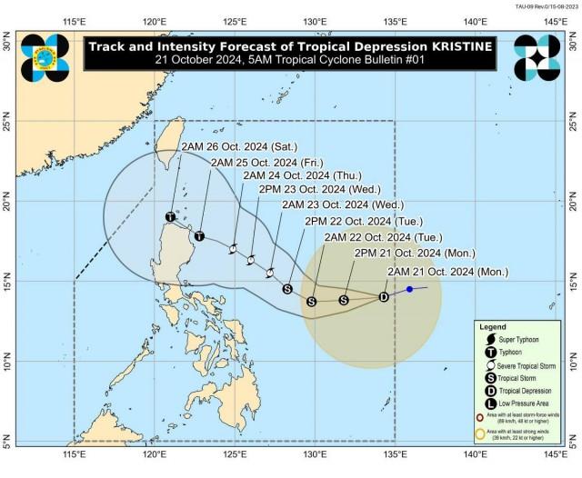
Kristine's track shows it will move generally westward on Monday until Tuesday morning, then turn west northwestward to northwestward starting Tuesday afternoon until the rest of the forecast period.
It is expected to make landfall over Northern Luzon by Friday afternoon.
Kristine is also seen to intensify into a tropical storm in the next 12 hours, then reach severe tropical storm category by Tuesday afternoon or evening. It is then forecast to further intensify and reach typhoon category by Thursday afternoon or evening prior to making landfall over the northeastern portion of Cagayan.
"Since this tropical cyclone is still over the Philippine Sea, further intensification is likely, given the favorable environmental conditions (high SST and low wind shear) for development over the area. Changes in forecast track is also not ruled out, depending on the movement of the weather systems over the mid-latitude over the next days," PAGASA said.
The weather bureau advised the public and disaster risk reduction and management offices concerned to take the necessary measures to protect life and property.
PAGASA will issue the next advisory at 11 a.m.
Meanwhile, classes have been suspended on Monday, Oct. 21, in some areas due to the bad weather caused by Kristine. —KG, GMA Integrated News
