

Signal No. 1 remains over Batanes as Julian weakens outside PAR
Batanes province remains under Signal No. 1 early Thursday morning as Typhoon Julian continues to weaken while slowly moving northeastward outside the Philippine area of responsibility (PAR) towards Taiwan, according to the latest PAGASA cyclone bulletin.
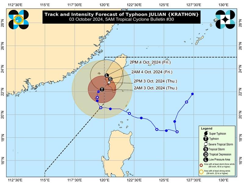
The center of the eye of the typhoon was estimated at 270 kilometers west northwest of Itbayat, Batanes outside PAR packing maximum sustained winds of 155 kilometers per hour near the center and gustiness of up to 190 kph.
Tropical Cyclone Wind Signal (TCWS) No. 1 remains over Batanes.
Typhoon Julian will continue to bring cloudy skies with scattered rains over extreme Northern Luzon while the easterlies will be affecting the eastern section of Mindanao.
Batanes and Babuyan Islands will have cloudy skies with scattered rains and thunderstorms due to Typhoon Julian with the possibility that flash floods or landslides will occur due to moderate to at times heavy rains.
Ilocos Region, Cordillera Administrative Region, the rest of Cagayan Valley, and Central Luzon will have cloudy skies with scattered rains and thunderstorms due to the trough of Typhoon Julian with the possibility that flash floods or landslides will occur due to moderate to at times heavy rains.
Davao Region, SOCCSKSARGEN, and Caraga will have cloudy skies with scattered rains and thunderstorms due to the easterlies with the possibility that flash floods or landslides will occur due to moderate to at times heavy rains
Metro Manila and the rest of countryPartly cloudy to cloudy skies with isolated rainshowers or thunderstorms due to localized thunderstorms with the possibility that flash floods or landslides will occur during severe thunderstorms.
Hazards affecting coastal waters
A Gale Warning is hoisted over the northern seaboard of Northern Luzon.
The wind speed forecast for Northern Luzon is strong and moving in the northwest to southwest with rough coastal waters.
Central Luzon will experience moderate to strong wind speed moving northwestward with moderate to rough coastal waters.
The rest of the country will experience light to moderate wind speed moving in the east to northeast direction with slight to moderate coastal waters.
PAGASA warned that sea travel is risky for most types or tonnage of vessels and mariners are advised to remain in port or seek safe shelter or harbor.
Track and Intensity outlook
"Julian is forecast to make landfall over southwestern Taiwan this morning or afternoon after entering the northwestern boundary of the Philippine Area of Responsibility (PAR)," said PAGASA.
"Due to a combination of incoming northeasterly wind flow over the East China Sea and Taiwan Strait and lower ocean heat content in its vicinity (which is related to upwelling of cooler waters caused by its slow movement for nearly two days), Julian is forecast to continue weakening. Despite its re-entry in the PAR region, no direct effect is anticipated over the country except for Batanes, which is relatively close to Taiwan," the agency added. — BAP, GMA Integrated News
