

Signal No. 2 up over 4 Luzon areas as Julian intensifies outside PAR
State weather bureau PAGASA on Tuesday said four areas in Luzon were under Tropical Cyclone Wind Signal (TCWS) No. 2 as Super Typhoon Julian slightly intensified outside the Philippine area of responsibility (PAR).
In its 11 a.m. bulletin, PAGASA said TCWS No. 2 was hoisted in the following areas:
- Batanes
- Babuyan Islands
- northern portion of Ilocos Norte (Bacarra, Pasuquin, Bangui, Vintar, Burgos, Pagudpud, Dumalneg, Adams)
- northwestern portion of mainland Cagayan (Santa Praxedes, Claveria, Sanchez-Mira)
Meanwhile, TCWS No. 1 is raised in the following areas:
- the rest of Ilocos Norte
- Ilocos Sur
- La Union
- Pangasinan
- Apayao
- Kalinga
- Abra
- Mountain Province
- Ifugao
- Benguet
- the rest of mainland Cagayan
- Isabela
- Quirino
- Nueva Vizcaya
- the northern portion of Aurora (Dilasag, Casiguran, Dinalungan)
- the northern portion of Nueva Ecija (Carranglan, Lupao, Pantabangan)
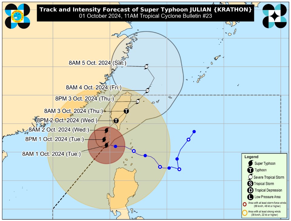
PAGASA said that as of 10 a.m., Julian was located 235 kms. west of Itbayat, Batanes with maximum sustained winds of 195 kph near the center and gustiness of up to 240 kph.
The super typhoon was moving westward slowly, it added.
"On the track forecast, the super typhoon will make landfall along the southwestern coast of Taiwan tomorrow morning or afternoon. It will then cross the rugged terrain of Taiwan before emerging over the sea east of Taiwan on Thursday (3 October) morning," PAGASA said.
"Afterwards, JULIAN will move northeastward towards the East China Sea, and exit the Philippine Area of Responsibility on Thursday evening or Friday (4 October) early morning, then turn northwestward on Friday evening to Saturday (6 October) early morning once over the East China Sea," it added. — VDV, GMA Integrated News
