

Julian now a super typhoon, Signal No. 2 raised over four areas
Julian intensified into a super typhoon and is now moving slowly in the west northwest direction while signal No. 2 is raised over four areas, according to the latest Tropical Cyclone Bulletin posted by PAGASA.
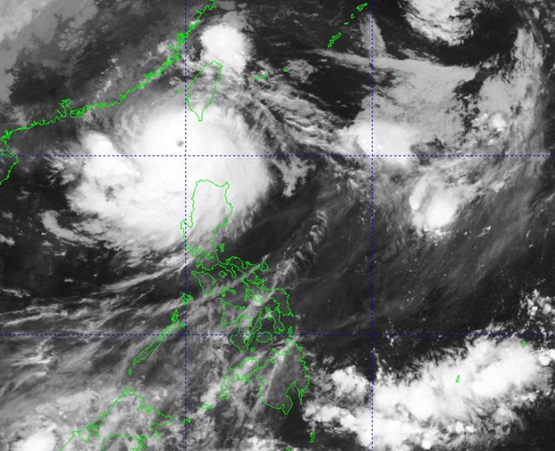
The center of the eye of Julian (international name: Krathon) was estimated at 4 a.m. to be located 205 kilometers west of Itbayat, Batanes packing maximum sustained winds of 185 kilometers per hour near the center and gustiness of up to 230 kph.
Julian was moving west northwestward slowly.
Tropical Cyclone Wind Signal (TCWS) No. 2 was hoisted at 5 a.m. over the following areas:
- Batanes;
- Babuyan Islands;
- the northern portion of Ilocos Norte (Bacarra, Pasuquin, Bangui, Vintar, Burgos, Pagudpud, Dumalneg, Adams); and
- the northwestern portion of mainland Cagayan (Santa Praxedes, Claveria, Sanchez-Mira).
TCWS No. 1 was raised over the following areas:
- the rest of Ilocos Norte;
- Ilocos Sur;
- La Union;
- Pangasinan;
- Apayao;
- Kalinga;
- Abra;
- Mountain Province;
- Ifugao;
- Benguet;
- the rest of mainland Cagayan;
- Isabela;
- Quirino;
- Nueva Vizcaya;
- the northern portion of Aurora (Dilasag, Casiguran, Dinalungan); and
- the northern portion of Nueva Ecija (Carranglan, Lupao, Pantabangan).
Weather conditions
Batanes, Cagayan including Babuyan Islands, Apayao, and Ilocos Norte will be stormy due to Super Typhoon Julian with the possibility that flash floods or landslides will occur due to heavy to intense with at times torrential rains. There will be minor to moderate threat to lives and properties due to strong winds.
The rest of Ilocos Region, rest of Cordillera Administrative Region, and rest of Cagayan Valley will have rains with gusty winds also due to Julian with the possibility that flash floods or landslides will occur due to moderate to heavy with at times intense rains. Minimal to minor threat to lives and properties due to strong winds may be expected.
Metro Manila, Central Luzon, CALABARZON, and Occidental Mindoro will have cloudy skies with scattered rains and thunderstorms due to the trough of Super Typhoon Julian with the possibility that flash floods or landslides will occur due to moderate to at times heavy rains.
The rest of the country will have partly cloudy to cloudy skies with isolated rain showers or thunderstorms due to localized thunderstorms with the possibility that flash floods or landslides will occur during severe thunderstorms.
Severe winds
PAGASA said that minor to moderate impacts from gale-force winds are possible within any of the localities where TCWS No. 2 was hoisted while minimal to minor impacts from strong winds are possible within any of the areas under TCWS No. 1.
Strong to gale-force gusts may also be expected over the following areas (especially in coastal and upland areas exposed to winds): Ilocos Region, Cordillera Administrative Region, the northern and eastern portions of mainland Cagayan, the eastern portion of Isabela, Aurora, Zambales, Bataan, Metro Manila, CALABARZON, Romblon, and Camarines Norte
Coastal inundation
"There is a moderate to high risk of life-threatening storm surge in the next 48 hours over the low-lying or exposed coastal localities of Batanes and Babuyan Islands," said PAGASA.
Meanwhile, a gale warning was hoisted over the northern and western seaboards of Northern Luzon.
24-Hour sea condition outlook
High seas of up to 7.0 m are forecast over the seaboard of Batanes
Sea travel is risky for all types or tonnage of vessels. All mariners must remain in port or, if underway, seek shelter or safe harbor as soon as possible until winds and waves subside.
The seaboards of Babuyan Islands and Ilocos Norte will have very rough seas up to 6.0 m.
Meanwhile coastal waters may reach up to 4.5 m over the seaboard of northern Ilocos Sur.
"Sea travel is risky for most types or tonnage of vessels, including all small seacrafts and motorbancas. Mariners are advised to remain in port or seek safe shelter or harbor," the weather bureau said.
Moderate or rough seas may be expected over the following coastal waters:
- Up to 3.5 m over the seaboard of mainland Cagayan and the remaining seaboard of Ilocos Sur
- Up to 3.0 m over the remaining seaboard of Ilocos Region and the seaboard of Isabela
- Up to 2.5 m over the seaboard of northern Aurora and northern Zambales
In these areas, PAGASA warned that mariners of small seacrafts, including all types of motorbancas, are advised not to venture out to sea under these conditions, especially if inexperienced or operating ill-equipped vessels.
Track and intensity outlook
"Super Typhoon Julian is forecast to recurve towards the sea southwest of Taiwan today through tomorrow (2 October) early morning," said PAGASA.
Julian will make landfall along the southwestern coast of Taiwan on Wednesday morning or afternoon then cross the rugged terrain of Taiwan before emerging over the sea east of Taiwan by Wednesday evening or on Thursday early morning.
It is forecast to move northeastward towards the East China Sea, exit the Philippine Area of Responsibility on Thursday afternoon or evening, then turn northwestward on Friday once over the East China Sea.
Effects
Classes were suspended on Tuesday, October 1, in some areas due to the bad weather caused by Julian. — BAP/KG, GMA Integrated News
