

Batanes still under Signal No. 4 as Julian may intensify into super typhoon
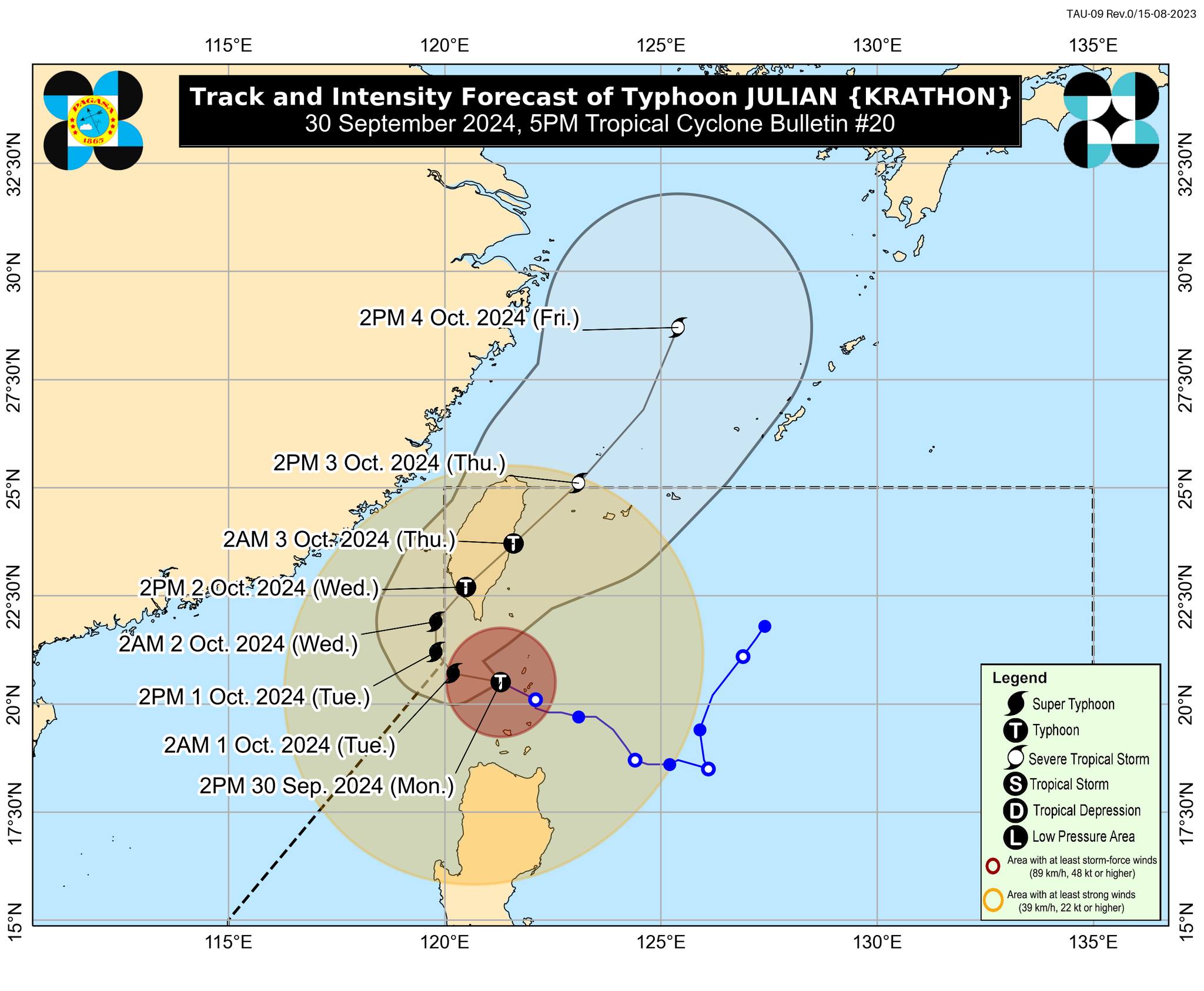
Tropical Cyclone Wind Signal (TCWS) No. 4 is still hoisted over Batanes as Typhoon Julian may reach super typhoon category this evening, PAGASA said late Monday afternoon.
“The peak of devastating typhoon-force winds will be felt over under Wind Signal No. 4 until evening,” PAGASA said in its 5 p.m. bulletin.
The center of the eye of Julian (international name: Krathon) was last located 95km west southwest of Ikbayat, Batanes.
PAGASA said Julian has a maximum sustained winds of 175 kph near the center, gustiness of up to 215 kph, and is moving west northwestward at 15kph.
Signal No. 3 was raised over northern and western portions of Babuyan Islands (Babuyan Islands, Calayan Islands, Dalupiri Islands, and Fuga Islands)
Signal No. 2 is hoisted over the following areas:
- The northern and westwern portion of Mainland Cagayan (Piat, Santo Nino, Camalaniugan, Tuao, Lal-Lo, Pamplona, Gonzaga, Alcala, Amulung, Santa Teresita, Baggao, Buguey, Solana, Rizal, Claveria, Gattaran, Iguig, Lasam, Aparri, Ballesteros, Abulug, Allacapan, Sanchez-Mira, Santa Praxedes, Santa Ana)
- The rest of Babuyan Islands
- Apayao
- Abra
- Kalinga
- Ilocos Norte
- The northern and central portions of Ilocos Sur (Sinait, Cabugao, San Emilio, Lidlidda, Banayoyo, Santiago, Santa Maria, Burgos, San Esteban, Nagbukel, Narvacan, Santa, Caoayan, Bantay, Santo Domingo, San Juan, San Vicente, San Ildefonso, Magsingal, Santa Catalina, City of Vigan)
Meanwhile Signal No. 1 is hoisted over the following areas:
- The rest of Ilocos Sur
- La Union
- Pangasinan
- Ifugao
- Mountain Province
- Benguet
- The rest of Mainland Cagayan (Peñablanca, Tuguegarao City, Enrile)
- Isabela
- Nueva Vizcaya
- Quirino
- The northern portion of Aurora (Dilasag, Casiguran, Dinalungan), and the northern portion of Nueva Ecija (Carranglan, Lupao, Pantabangan)
PAGASA said Julian may bring strong to gale-force gusts over Ilocos Region, Cordillera Administrative Region, northern and eastern portions of mainland Cagayan, the eastern portion of Isabela, Aurora, Zambales, Bataan, Metro Manila, Calabarzon, Romblon, Camarines Norte, Camarines Sur, and Catanduanes on Tuesday.
A gale warning is also in effect over the seaboards of Northern Luzon. Small vessels were warned of the risk of sea travel.
PAGASA said Julian is seen to move generally west northwestward to northwestward over the Bashi Channel on Monday and will begin "recurving" on Tuesday.
“JULIAN may briefly leave the Philippine Area of Responsibility (PAR) during this period but bulletins are expected to continue,” PAGASA said.
Julian is expected to exit the Philippine area of responsibility on Thursday.
The typhoon has prompted several local government units to suspend classes for the day. Some courts also announced work suspension.
According to Batanes Governor Marilou Cayco, Julian has been heavily felt in the province since Sunday night, prompting many residents to evacuate.—Mariel Celine Serquiña/AOL, GMA Integrated News
