

Batanes, under Signal No. 4, warned of 'devastating' winds due to Julian
Batanes remained until Tropical Cyclone Wind Signal (TCWS) No. 4 due to Typhoon Julian on Monday afternoon and is warned to brace for "the peak of devastating typhoon-force winds" until the evening.
"The peak of devastating typhoon-force winds will be felt over areas under Wind Signal No. 4 this afternoon until evening," state weather forecasters PAGASA said in its 2 p.m. bulletin.
"Furthermore, the possibility of hoisting Wind Signal No. 5 is not ruled out."
According to Batanes Governor Marilou Cayco, Julian has been heavily felt in the province since Sunday night, prompting many residents to evacuate.
The typhoon has prompted several local government units to suspend classes for the day. Some courts also announced work suspension.
Meanwhile, PAGASA said the following areas in Luzon are under Tropical Cyclone Winds Signals:
TCWS No. 3
- Babuyan Islands
TCWS No. 2
- Mainland Cagayan
- Apayao
- Abra
- Kalinga
- Ilocos Norte
- The northern and central portions of Ilocos Sur (Sinait, Cabugao, San Emilio, Lidlidda, Banayoyo, Santiago, Santa Maria, Burgos, San Esteban, Nagbukel, Narvacan, Santa, Caoayan, Bantay, Santo Domingo, San Juan, San Vicente, San Ildefonso, Magsingal, Santa Catalina, City of Vigan)
TCWS No. 1
- The rest of Ilocos Sur
- La Union
- Pangasinan
- Ifugao
- Mountain Province
- Benguet
- Isabela
- Nueva Vizcaya
- Quirino
- The northern and central portions of Aurora (Dilasag, Casiguran, Dinalungan, Dipaculao, Maria Aurora, Baler, San Luis)
- The northern and eastern portions of Nueva Ecija (Cuyapo, Rizal, Laur, Pantabangan, Science City of Muñoz, Gabaldon, Carranglan, San Jose City, Lupao, Talugtug, Bongabon, Llanera, Talavera, Palayan City, General Mamerto Natividad)
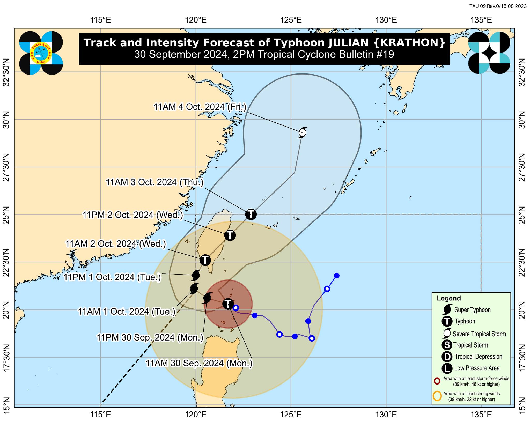
Maintaining its strength, Julian (international name: Krathon) was last spotted by PAGASA over the coastal waters of Sabtang Islands, Batanes packing maximum sustained winds of 175 kph near the center and gustiness of up to 240 kph. It was moving west northwestward at 15 kph.
PAGASA said residents of low-lying or exposed coastal localities of Batanes, Cagayan, and Ilocos Norte should be wary of life-threatening storm surges in the next 48 hours.
"Julian will continue intensifying and may reach super typhoon category this afternoon or evening, PAGASA said.
It added that Julian may bring strong to gale-force gusts over Ilocos Region, Cordillera Administrative Region, northern and eastern portions of mainland Cagayan, the eastern portion of Isabela, Aurora, Zambales, Bataan, Metro Manila, Calabarzon, Romblon, Camarines Norte, Camarines Sur, and Catanduanes on Tuesday.
A gale warning is in effect over the seaboards of Northern Luzon. Small vessels were warned of the risk of sea travel.
Julian is seen to move generally west northwestward to northwestward over the Bashi Channel on Monday and will begin "recurving" on Tuesday. It is expected to make landfall over the southwestern coast of Taiwan on Wednesday.
“JULIAN may briefly leave the Philippine Area of Responsibility (PAR) during this period but bulletins are expected to continue,” PAGASA said.
Julian is expected to exit the Philippine area of responsibility on Thursday. —Mariel Celine Serquiña/KBK, GMA Integrated News
