

Signal No. 4 still up over Batanes, part of Babuyan Islands as Julian passes near Sabtang Island
Tropical Cyclone Wind Signal (TCWS) No. 4 remained hoisted over Batanes and the northern portion of Babuyan Islands as slow-moving Typhoon Julian passed near Sabtang Island on Monday, PAGASA said.
In its 11 a.m. bulletin, PAGASA said the following areas in Luzon are under Tropical Cyclone Winds Signals:
TCWS No. 4
- Batanes
- northern portion of Babuyan Islands (Babuyan Is., Calayan Is.)
TCWS No. 3
- the rest of Babuyan Islands
- northeastern portion of mainland Cagayan (Santa Ana)
TCWS No. 2
- the rest of mainland Cagayan
- Apayao
- Abra
- Kalinga,
- Ilocos Norte
- northern and central portions of Ilocos Sur (Sinait, Cabugao)
TCWS No. 1
- the rest of Ilocos Sur
- La Union
- Pangasinan
- Ifugao
- Mountain Province
- Benguet
- Isabela
- Nueva Vizcaya
- Quirino
- Aurora
- northern and eastern portions of Nueva Ecija (Cuyapo, Rizal, Laur, Pantabangan, Science City of Muñoz, Gabaldon, Carranglan, San Jose City, Lupao, Talugtug, Bongabon, Llanera, Talavera, Palayan City, General Mamerto Natividad)
- Polillo Islands
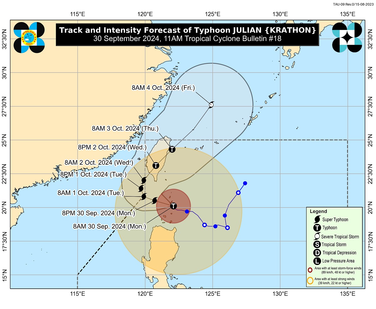
Julian was located over the coastal waters of Sabtang Island, Batanes with maximum sustained winds of 175 kilometers per hour near the center and gustiness of up to 215 kph. It was moving north northwestward at 10 kph.
Based on PAGASA's forecast track, Julian may move generally west northwestward over the Bashi Channel on Monday and will begin recurving on Tuesday while moving slowly.
It will turn generally north northeastward to northeastward on Wednesday towards the southwestern coast of Taiwan, where it is forecast to make landfall on the same day.
“Julian may briefly leave the Philippine Area of Responsibility (PAR) during this period but bulletins are expected to continue,” PAGASA said.
“The typhoon will then cross the rugged terrain of Taiwan and emerge over the waters east of Taiwan by Thursday (3 October) morning. Afterwards, the typhoon will gradually accelerate northeastward towards the East China Sea and exit the PAR region on Thursday,” it added.
Julian may reach super typhoon category Monday afternoon or evening, according to PAGASA.
Signal No. 5?
The peak of devastating typhoon-force winds will be felt over areas under TCWS No. 4 between Monday morning and afternoon, according to PAGASA.
“Furthermore, the possibility of hoisting Wind Signal No. 5 is not ruled out,” PAGASA said.
Based on PAGASA's 11 a.m. weather advisory for Julian, intense to torrential rains are expected over Batanes, Babuyan Islands, and llocos Norte on Monday. Heavy to intense rains may be experienced in Mainland Cagayan, llocos Sur, La Union, Apayao, Abra, and Benguet.
Meanwhile, moderate to heavy rains may prevail over Pangasinan, Zambales, Bataan, and the rest of Cordillera Administrative Region.
Moderate to high risk of life-threatening storm surge may occur over the low-lying or exposed coastal localities of Batanes, Cagayan, and Ilocos Norte in the next 48 hours.
A gale warning was raised over the seaboards of Northern Luzon.
Very high seas up to 14.0 meters are expected over the seaboards of Batanes and Babuyan Islands.
“Sea travel is risky all types or tonnage of vessels. All mariners must remain in port or, if underway, seek shelter or safe harbor as soon as possible until winds and waves subside,” PAGASA said.
Very rough seas of up to 6.0 meters may be experienced over the northern seaboard of Ilocos Norte, northern seaboard of mainland Cagayan, and the remaining seaboard of Ilocos Norte.
“Sea travel is risky for most types or tonnage of vessels, including all small seacrafts and motorbancas. Mariners are advised to remain in port or seek safe shelter or harbor,” PAGASA said.
Moderate or rough seas of up to 4.0 meters may be encountered over the remaining seaboard of Cagayan, Ilocos Sur, Isabela, northern portion of Aurora, the remaining seaboard of Ilocos Region, the remaining seaboard of Aurora as well as the northern and eastern seaboard of Polillo Islands.
“Mariners of small seacrafts, including all types of motorbancas, are advised not to venture out to sea under these conditions, especially if inexperienced or operating ill-equipped vessels,” PAGASA said.
According to Batanes Governor Marilou Cayco, Julian has been heavily felt in the province since Sunday night, resulting in evacuations.
The typhoon has prompted several local government units to suspend classes for the day. Some courts also announced work suspension. —Joviland Rita/KBK, GMA Integrated News
