

Julian nears super typhoon level; Signal No. 4 up over Batanes, part of Babuyan Islands
Tropical Cyclone Wind Signal No. 4 was raised over Batanes and the northern portion of Babuyan Islands on Monday morning as Typhoon Julian (international name: Krathon) is close to reaching super typhoon category, state weather bureau PAGASA said.
In its 8 a.m. bulletin, PAGASA said the following areas in Luzon are under Tropical Cyclone Wind Signals:
TCWS No. 4
- Batanes;
- northern portion of Babuyan Islands (Babuyan Is., Calayan Is.)
TCWS No. 3
- the rest of Babuyan Islands;
- northeastern portion of mainland Cagayan (Santa Ana)
TCWS No. 2
- the rest of mainland Cagayan;
- Apayao;
- northern portion of Abra (Tineg, Lacub, Malibcong, Licuan-Baay, San Juan, Lagayan, Lagangilang, Dolores, Daguioman, Danglas, La Paz);
- northern portion Kalinga (Pinukpuk, Balbalan, City of Tabuk, Rizal);
- Ilocos Norte; and
- the northern portion of Ilocos Sur (Sinait, Cabugao)
TCWS No. 1
- the rest of Ilocos Sur;
- La Union;
- Pangasinan;
- the rest of Abra;
- the rest of Kalinga;
- Ifugao;
- Mountain Province;
- Benguet;
- Isabela;
- Nueva Vizcaya;
- Quirino;
- Aurora;
- the northern eastern portions of Nueva Ecija (Cuyapo, Rizal, Laur, Pantabangan, Science City of Muñoz, Gabaldon, Carranglan, San Jose City, Lupao, Talugtug, Bongabon, Llanera, Talavera, Palayan City, General Mamerto Natividad); and
- Polillo Islands.
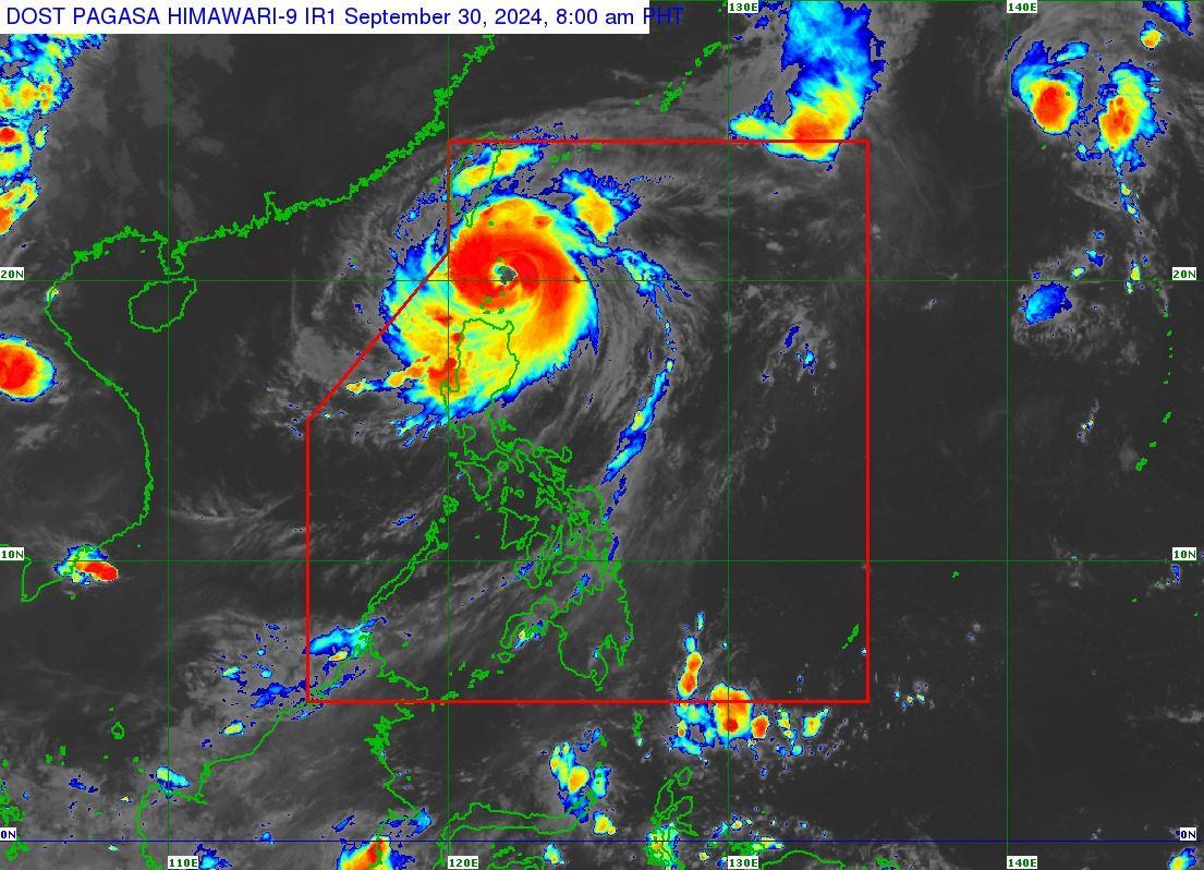
Julian was located at 7 a.m. over the coastal waters of Balintang Island in Calayan, Cagayan packing maximum sustained winds of 175 kilometers per hour near the center and gustiness of up to 215 kph.
It was moving west northwestward at 10 kph.
PAGASA said Julian may make landfall over Balintang Island or Batanes on Monday and may reach the super typhoon category on Tuesday.
“JULIAN is forecast to move generally west northwestward over the Balintang Channel today and pass very close to Balintang Island and Batanes. A landfall scenario over these areas remains likely. Nevertheless, this typhoon will be at its closest to Batanes and Babuyan Islands this morning through afternoon,” PAGASA said.
“JULIAN will continue intensifying and may reach super typhoon category tomorrow at the start of its recurvature. Interaction with the rugged terrain of Taiwan will trigger a weakening trend prior to landfall, although JULIAN is forecast to remain as a typhoon until it exits the PAR region,” it added.
Winds, rain
The peak of devastating typhoon-force winds will be felt over areas under TCWS No. 4 between Monday morning and afternoon, according to PAGASA.
“Furthermore, the possibility of hoisting Wind Signal No. 5 is not ruled out,” PAGASA said.
Based on PAGASA 8 a.m. weather advisory for Julian, intense to torrential rains are expected over Batanes, Babuyan Islands, and llocos Norte on Monday.
Heavy to intense rains may be experienced in Mainland Cagayan, llocos Sur, La Union, Apayao, Abra, and Benguet.
Meanwhile, moderate to heavy rains may prevail over Pangasinan, Zambales, Bataan, and the rest of Cordillera Administrative Region.
Storm surge
Moderate to high risk of life-threatening storm surge may occur over the low-lying or exposed coastal localities of Batanes, Cagayan, and Ilocos Norte in the next 48 hours.
A gale warning was raised over the seaboards of Northern Luzon.
Very high seas up to 14.0 meters are expected over the seaboards of Batanes and Babuyan Islands.
“Sea travel is risky all types or tonnage of vessels. All mariners must remain in port or, if underway, seek shelter or safe harbor as soon as possible until winds and waves subside,” PAGASA said.
Very rough seas of up to 6.0 meters may be experienced over the northern seaboard of Ilocos Norte, northern seaboard of mainland Cagayan, and the remaining seaboard of Ilocos Norte.
“Sea travel is risky for most types or tonnage of vessels, including all small seacrafts and motorbancas. Mariners are advised to remain in port or seek safe shelter or harbor,” PAGASA said.
Moderate or rough seas of up to 4.0 meters may be encountered over the remaining seaboard of Cagayan, Ilocos Sur, Isabela, northern portion of Aurora, the remaining seaboard of Ilocos Region, the remaining seaboard of Aurora as well as the northern and eastern seaboard of Polillo Islands.
“Mariners of small seacrafts, including all types of motorbancas, are advised not to venture out to sea under these conditions, especially if inexperienced or operating ill-equipped vessels,” PAGASA said.
Effects
Classes for Monday, September 30, 2024 have been suspended in some areas due to the effects of Typhoon Julian.
Residents in some towns in Batanes have evacuated their homes.
Strong winds and rains were affecting the town of Basco in Batanes on Monday morning, as seen in a video shared by Batanes Governor Marilou Cayco.
Cayco said some areas in the province are experiencing power outages. —Joviland Rita/KG, GMA Integrated News
