Signal No. 4 up over Batanes, part of Babuyan Islands as Julian brings violent winds
Tropical Cyclone Wind Signal (TCWS) No. 4 was hoisted at 5 a.m. on Monday over Batanes and the northern portion of Babuyan Islands (Babuyan Island and Calayan Island) as Typhoon Julian brought violent winds, PAGASA said in its bulletin.
The typhoon-force winds with speeds of 118 to 184 km/h are to be felt in 12 hours, posing significant to severe threat to life and property.
TCWS No. 3 meanwhile was raised over the rest of Babuyan Islands and the northeastern portion of mainland Cagayan (Santa Ana).
Areas under TCWS No. 3 will have storm-force winds with speeds of 89 to 117 km/h in 18 hours, which may pose moderate to significant threat to life and property.
TCWS No. 2 on the other hand is in effect over the rest of mainland Cagayan, Apayao, and Ilocos Norte.
These areas will experience gale-force winds with speeds of 62 to 88 km/h in 24 hours which may pose minor to moderate threat to life and property.
TCWS No. 1 was hoisted meanwhile over:
- Ilocos Sur;
- La Union;
- Pangasinan;
- Abra;
- Kalinga;
- Ifugao;
- Mountain Province;
- Benguet;
- Isabela;
- Nueva Vizcaya;
- Quirino;
- Aurora;
- the northern and eastern portions of Nueva Ecija (Cuyapo, Rizal, Laur, Pantabangan, Science City of Muñoz, Gabaldon, Carranglan, San Jose City, Lupao, Talugtug, Bongabon, Llanera, Talavera, Palayan City, General Mamerto Natividad); and
- Polillo Islands.
Areas under TCWS No. 1 will have strong winds with speeds of 39 to 61 km/h in 36 hours, posing minimal to minor threat to life and property.
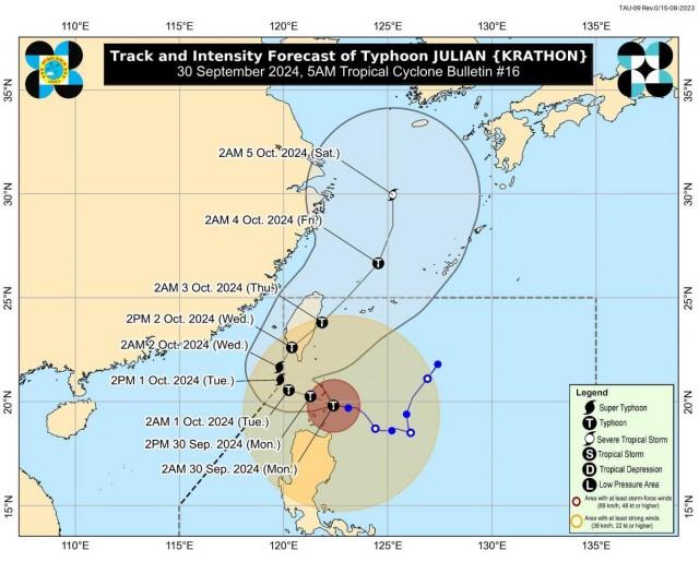
At 4 a.m., the center of Julian (international name: Krathon) was estimated to be located over the coastal waters of Balintang Island in Calayan, Cagayan.
The typhoon has maximum sustained winds of 155 km/h near the center, gustiness of up to 190 km/h, and central pressure of 950 hPa.
Typhoon Julian is moving westward at 10 km/h, with strong to typhoon-force winds extending outwards up to 560 km from its center.
"JULIAN is forecast to move generally west northwestward over the Balintang Channel today and pass very close to Balintang Island and Batanes. A landfall scenario over these areas remains likely," PAGASA said.
The typhoon will be at its closest to Batanes and Babuyan Islands on Monday morning until afternoon.
"Julian will continue intensifying and may reach super typhoon category tomorrow at the start of its recurvature," PAGASA said.
It is forecast to exit the Philippine Area of Responsibility (PAR) on Thursday morning or afternoon.
Rainfall
Batanes, Cagayan including Babuyan Islands, Apayao, and Ilocos Norte will have stormy weather conditions. Heavy to intense with at times torrential rains may possibly lead to flash floods or landslides.
Aurora, and the rest of Ilocos Region, Cordillera Administrative Region and Cagayan Valley may have rains with gusty winds with flash floods or landslides possibly occurring due to moderate to heavy with at times intense rains.
Metro Manila, CALABARZON, Oriental Mindoro, Occidental Mindoro, Marinduque, Camarines Norte, Camarines Sur, and the rest of Central Luzon will have cloudy skies with scattered rains and thunderstorms due to the trough or extension of the outer rain bands of Julian. Moderate to at times heavy rains may possibly cause flash floods or landslides.
The rest of the country on the other hand will have partly cloudy to cloudy skies with isolated rainshowers or thunderstorms due to localized thunderstorms. During severe thunderstorms, flash floods or landslides may result.
Severe winds
Areas under TCWS No. 4 will feel the peak of devastating typhoon-force winds between Monday morning and afternoon, and these may result in significant to severe impact, PAGASA said.
Those under TCWS No. 3 may have moderate to significant impact from storm-force winds.
"Minor to moderate impacts from gale-force winds are possible within any of the localities where Wind Signal No. 2 is hoisted," PAGASA said.
Meanwhile, areas under TCWS No. 1 may experience minimal to minor impacts from strong winds.
Strong to gale-force gusts may possibly be felt on Monday in Pangasinan, Aurora, Zambales, Bataan, Metro Manila, CALABARZON, Romblon, and Bicol Region, especially in coastal and upland areas exposed to winds.
Coastal waters
PAGASA raised a gale warning over the seaboards of Northern Luzon.
The seaboards of Batanes will have very high seas up to 14.0 meters in 24 hours, and up to 10.0 meters over the seaboards of Babuyan Islands.
"Sea travel is risky all types or tonnage of vessels. All mariners must remain in port or, if underway, seek shelter or safe harbor as soon as possible until winds and waves subside," the weather bureau said.
Meanwhile, the northern seaboard of Ilocos Norte, the northern seaboard of mainland Cagayan and the remaining seaboard of Ilocos Norte will have very rough seas, making sea travel risky for most types or tonnage of vessels. PAGASA advised mariners to remain in port or seek safe shelter or harbor.
Coastal waters will be moderate to rough over the remaining seaboard of Cagayan, and the seaboards of Ilocos Sur, Isabela, northern portion of Aurora, remaining seaboard of Ilocos Region, remaining seaboard of Aurora, and northern and eastern seaboards of Polillo Islands.
"Mariners of small seacrafts, including all types of motorbancas, are advised not to venture out to sea under these conditions, especially if inexperienced or operating ill-equipped vessels," PAGASA said.
Meanwhile, coastal waters will be moderate to rough in Central Luzon and the eastern section of Southern Luzon, and slight to moderate in the rest of the country.
Track
Julian will start recurving on Tuesday while moving slowly.
It will then turn generally northeastward on Wednesday toward Taiwan's southwestern coast, and make landfall on Wednesday morning or afternoon.
PAGASA said Julian may briefly exit PAR during this period.
"The typhoon will then cross the rugged terrain of Taiwan and emerge over the waters east of Taiwan by Thursday (3 October) morning. Afterwards, the typhoon will gradually accelerate northeastward towards the East China Sea and exit the PAR region on Thursday morning or afternoon," it added.
The weather bureau advised the public and disaster risk reduction and management offices concerned to take all necessary measures to protect life and property.
Jebi
Meanwhile, PAGASA is also monitoring Tropical Storm Jebi which was located at 3 a.m. at 2,010 km east northeast of Extreme Northern Luzon.
Jebi has maximum sustained winds of 75 km/h and gustiness of up to 90 km/h.
It is moving north northwestward at 15 km/h.
Sunrise was at 5:46 a.m. while sunset will be at 5:46 p.m.
PAGASA will issue the next bulletin at 8 a.m.
Classes for Monday, September 30, 2024 have been suspended in some areas due to the effects of Typhoon Julian. —KG, GMA Integrated News

Kaufman says 5 lawyers ready to work on Duterte's defense at ICC

Duterte denied asylum in China before ICC arrest, says source who detailed arrest

ICC-accredited lawyer rejects 'warrantless' Duterte arrest claims