

Signal No. 4 in Batanes, part of Babuyan Islands as Typhoon Julian intensifies
Signal No. 4 has been hoisted over Batanes and the northeast portion of Babuyan Islands as Typhoon Julian continues to intensify, PAGASA said Sunday evening.
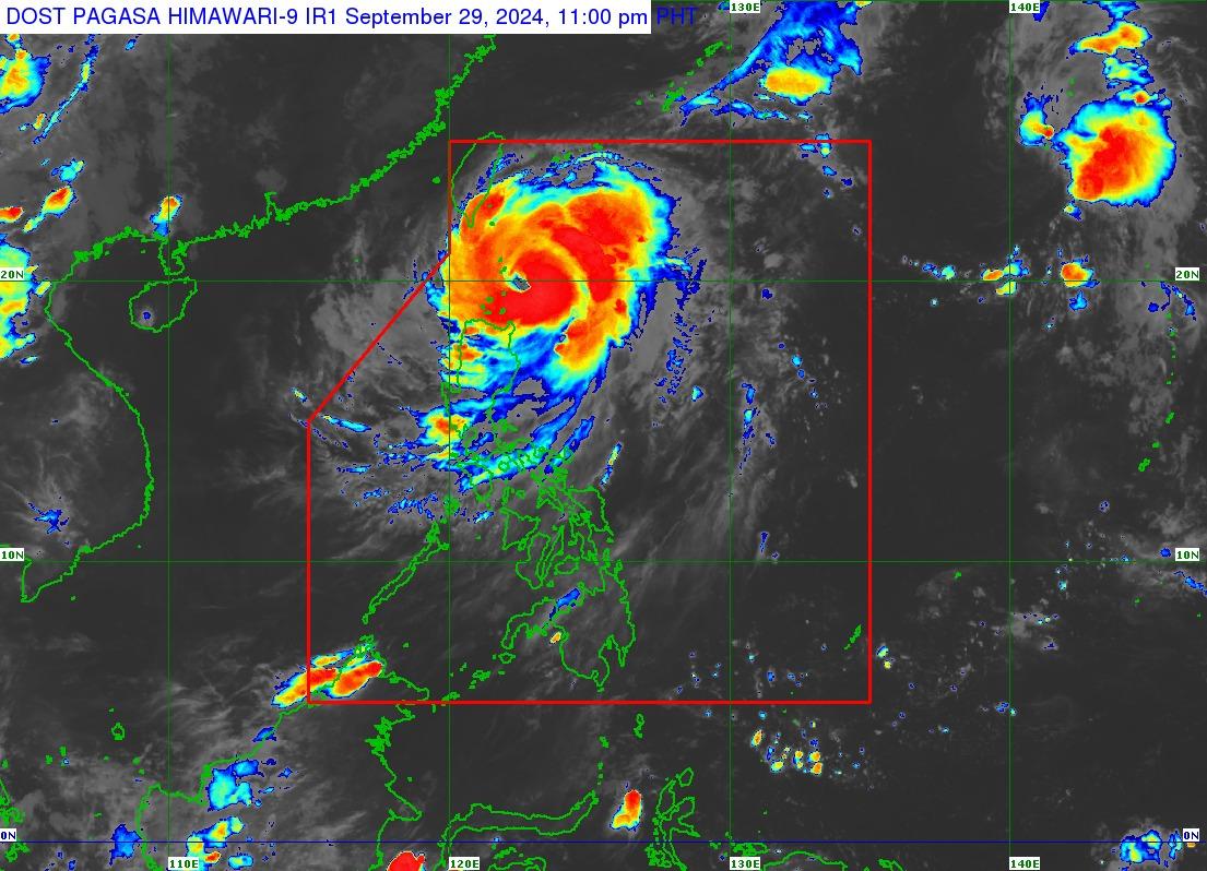
In its 11 p.m. tropical cyclone bulletin, the state weather bureau said that Julian (international name: Krathon) was moving westward at 15 km/h with maximum sustained winds of 150 km/h near the center and gustiness of up to 185 km/h, and with the center of the eye estimated based to be 125 km southeast of Basco, Batanes.
PAGASA also warned that a Signal No. 4 classification means the potential for typhoon-force winds greater than 118 kilometers per hour may be expected in at least 12 hours, with the risk of "significant to severe threat to life and property."
The other areas over which wind signals have been hoisted are:
Signal No. 3
- The rest of Babuyan Islands
Signal No. 2
- Mainland Cagayan
- Apayao
- Ilocos Norte
Signal No. 1
- Ilocos Sur
- La Union
- Abra
- Kalinga
- Ifugao
- Mountain Province
- Benguet
- Isabela
- Nueva Vizcaya
- Quirino
- the northern and central portions of Aurora (Dilasag, Casiguran, Dinalungan, Dipaculao, Maria Aurora, Baler, San Luis)
In addition, the wind flow coming towards the circulation of Typhoon Julian may also mean strong to gale-force gusts over Pangasinan, Zambales, Bataan, Metro Manila, Calabarzon, Romblon, and the Bicol Region from Sunday evening through to Monday, particularly in coastal and upland areas.
Possible landfall
Typhoon Julian is expected to make landfall or pass close to Batanes on Tuesday morning or afternoon, before sharply turning northward toward Taiwan where it is expected to make landfall on Tuesday evening or Wednesday morning.
“Julian is forecast to continue intensifying over the next 48 hours and may reach super typhoon category before making its landfall over southern Taiwan. In this case, Julian will pass near or over Batanes during its intensification period,” the weather bulletin said.
Forecast rainfall
From Sunday evening to Monday evening, Typhoon Julian is expected to bring intense to torrential rainfall (greater than 200 mm) to Batanes, Babuyan Islands, and Ilocos Norte; heavy to intense rainfall (100 to 200 mm) to mainland Cagayan, Ilocos Sur, La Union, Apayao, Benguet, and Abra; and moderate to heavy rainfall (50-100 mm) to Pangasinan, Zambales, Bataan and the rest of the Cordillera Administrative Region.
Gale warning
A gale warning has been issued for the northern and eastern seaboards of northern Luzon, with waves that may reach from 2.8 to 12.1 meters in the following areas:
- Batanes
- Cagayan including Babuyan Islands
- northern coast of Ilocos Norte
- Isabela
"Huwag munang pumalaot sa mga lugar na ito dahil sa inaasahang matataas na alon, lalo na sa bandang extreme northern Luzon," DOST-PAGASA Weather Specialist Aldczar D. Aurelio said in PAGASA's 11 p.m. video update.
(Do not set out to sea in there areas because large waves are expected, especially in extreme northern Luzon.) — Jon Viktor D. Cabuenas/BM, GMA Integrated News
