

Signal No. 3 in Batanes, part of Babuyan Islands as Typhoon Julian keeps strength
Tropical Cyclone Wind Signal (TCWS) No. 3 is now hoisted over Batanes and the northeastern portion of Babuyan Islands as Typhoon Julian has maintained its strengths on Sunday late afternoon, PAGASA said.
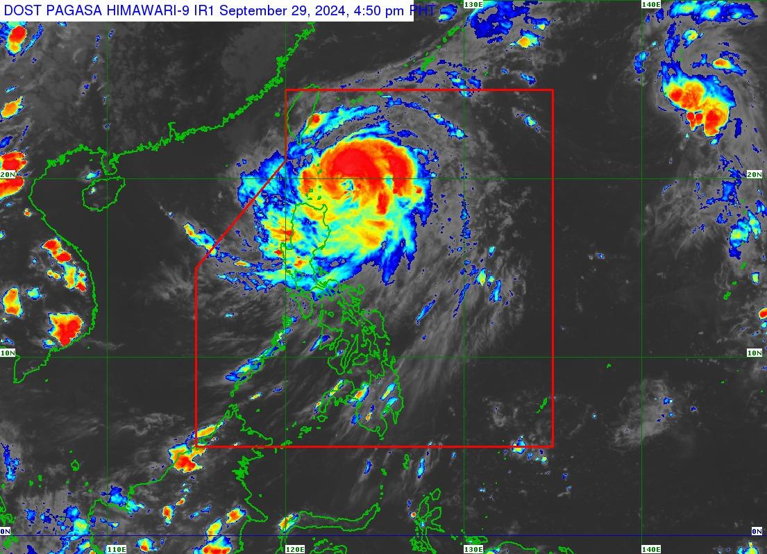
In its 5 p.m. bulletin, the state weather bureau said the center of the eye of Julian (international name: Krathon) was last spotted 235km east of Calayan, Cagayan.
PAGASA also said Julian is moving northwestward over the Philippine Sea east of Cagayan.
It has a maximum sustained winds of 120 kph near the center, gustiness of up to 150 kph, and is moving westward at 15 kph.
State meteorologists said Signal No. 2 is hoisted over the following areas:
- Mainland Cagayan
- The rest of Babuyan Islands (Camiguin Islands, Calayan Is., Dalupiri Islands, Fuga Island)
- Apayao
- The northern and central portions of Ilocos Norte (Pagudpud, Adams, Dumalneg, Bangui, Burgos, Pasuquin, Vintar, Carasi, Nueva Era, Solsona, Piddig, Dingras, Sarrat, San Nicolas, Laoag City, Bacarra).
Meanwhile, Signal No. 1 was raised over the following areas:
- The rest of Ilocos Norte
- Ilocos Sur
- La Union
- Abra
- Kalinga
- Ifugao
- Mountain Province
- Benguet
- Isabela
- Nueva Vizcaya
- Quirino
- The northern and central portions of Aurora (Dilasag, Casiguran, Dinalungan, Dipaculao)
PAGASA said moderate to significant storm surge may occur in the next 48 hours in the low-lying or exposed coastal localities of Batanes, Cagayan, and Ilocos Norte.
It added that Julian may bring strong to gale-force gusts over Pangasinan, Zambales, Bataan, Aurora, Quezon, Romblon, and Bicol Region on Monday.
A gale warning is in effect over the northern and eastern seaboards of Northern Luzon.
Small vessels were warned of the risk of sea travel.
Based on the track forecast, Julian may make landfall, or a close approach scenario by Monday over Batanes and/or Babuyan Islands is highly likely as the storm may continue to intensify over the next 24 to 36 hours.
“With the current trend in its intensification, the possibility of reaching super typhoon category is not ruled out,” the state weather bureau said.
Julian is seen to move generally west northwestward to northwestward from Sunday through Tuesday morning towards the Batanes-Babuyan Islands area, before accelerating north to north northeastward over the waters east of Taiwan on Tuesday afternoon onwards. — Mariel Celine Serquiña/BM, GMA Integrated News
