

Julian now a typhoon; Signal No. 3 still up over part of Babuyan Islands
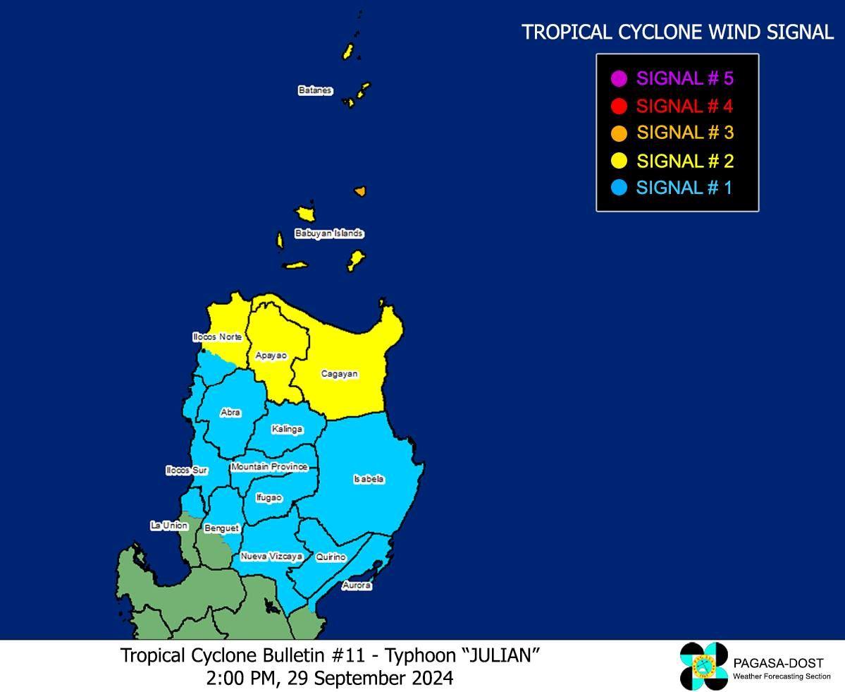
Tropical Cyclone Wind Signal (TCWS) No. 3 remained hoisted over the northeastern portion of Babuyan Islands as Julian intensified into a typhoon early Sunday afternoon, state weather bureau PAGASA said.
As of 2 p.m., PAGASA said that the center of the eye of Typhoon Julian (international name: Krathon) was last seen at 275 km east of Calayan, Cagayan.
It has a maximum sustained winds of 120 km/h near the center, gustiness of up to 135 km/h, and central pressure of 975 hPa.
The typhoon was also moving north northwestward at 15 km/h, with strong to storm-force winds extending outwards up to 490 km from the center.
Aside from the northeastern portion of Babuyan Islands which is under TCWS No. 3, PAGASA said that the following areas are under TCWS No. 2:
- Batanes;
- mainland Cagayan;
- the rest of Babuyan Islands (Camiguin Is., Calayan Is., Dalupiri Is., Fuga Is.);
- Apayao; and
- the northern and central portions of Ilocos Norte (Pagudpud, Adams, Dumalneg, Bangui, Burgos, Pasuquin, Vintar, Carasi, Nueva Era, Solsona, Piddig, Dingras, Sarrat, San Nicolas, Laoag City, Bacarra).
These areas may experience gale-force winds ranging 62 to 88 km/h within the next 24 hours, resulting in minor to moderate threat to life and property.
TCWS No. 1, on the other hand, was raised over the following areas:
- the rest of Ilocos Norte;
- Ilocos Sur;
- the northern portion of La Union (Santol, Sudipen, Bangar, Luna, Balaoan, San Gabriel, Bacnotan);
- Abra;
- Kalinga;
- Ifugao;
- Mountain Province;
- the northern and central portions of Benguet (Bakun, Mankayan, Buguias, Kabayan, Atok, Kibungan, Bokod, Kapangan);
- Isabela;
- Nueva Vizcaya;
- Quirino; and
- the northern and central portions of Aurora (Dilasag, Casiguran, Dinalungan, Dipaculao).
Strong winds ranging 39 to 61 km/h may be experienced in these areas, leading to minimal to minor threat to life and property.
According to PAGASA, the highest wind signal that may be hoisted during the occurrence of Julian is Signal No. 4.
The wind flow coming towards the circulation of the typhoon may also bring strong to gale-force gusts over the following areas, especially in coastal and upland areas exposed to winds:
- Sunday: Aurora, Calabarzon, Romblon, and Bicol Region
- Monday: Pangasinan, Zambales, Bataan, Aurora, Quezon, Romblon, and Bicol Region
Coastal waters
A gale warning is currently raised over the northern and eastern seaboards of Northern Luzon.
PAGASA said that very rough sea condition may be experienced over the following coastal waters, meaning sea travel is risky for most types or tonnage of vessels:
- Up to 9.0 m over the seaboards of Batanes
- Up to 7.0 m over the seaboards of Babuyan Islands
Rough sea conditionx, meanwhile, may be expected over the following areas:
- Up to 4.5 m over the northern seaboard of mainland Cagayan and the northern seaboard of Ilocos Norte
- Up to 3.5 m over and the remaining seaboard of Cagayan and the seaboard of Isabela
- Up to 3.0 m over the seaboard of the northern portion of Aurora
Moderate sea conditions of up to 2.5 meters may be experienced in the remaining seaboard of Ilocos Norte.
Track, intensity
Based on the track forecast, it is highly likely that Julian to make a landfall or close approach scenario by Monday over Batanes and/or Babuyan Islands.It is also seen to continue intensifying over the next 24-36 hours as it moves towards Batanes and/or Babuyan Islands.
“Considering the recent trend in its intensification, the possibility of reaching super typhoon category is not ruled out,” PAGASA said.
Julian is seen to move generally west northwestward to northwestward from Sunday through Tuesday morning towards the Batanes-Babuyan Islands area, before accelerating north to north northeastward over the waters east of Taiwan on Tuesday afternoon onwards.
Preparations
No evacuations were made yet in the provinces of Cagayan and Batanes despite the rainfall and wind threat brought by Julian, their respective provincial disaster risk reduction and management offices said Sunday.
However authorities are on alert and preparations have been made for disaster response. —KG/RF, GMA Integrated News
