

Julian now a severe tropical storm; Signal No. 2 up over 2 areas
The tropical storm named Julian has intensified into a severe tropical storm before dawn on Sunday, PAGASA said.
Tropical Cyclone Wind Signal No. 2 was hoisted at 5 a.m. over these two areas:
- the northeastern portion of Mainland Cagayan (Santa Ana)
- the eastern portion of Babuyan Islands (Camiguin Is., Babuyan Is.)
These areas will have gale-force winds with speeds of 62 to 88 km/h in 24 hours, posing minor to moderate threat to life and property.
TCWS No. 1 meanwhile was raised over the following:
- Batanes;
- the rest of Cagayan;
- the rest of Babuyan Islands;
- Isabela;
- Apayao;
- Abra;
- Kalinga;
- the eastern and central portions of Mountain Province (Natonin, Paracelis, Sadanga, Barlig, Bontoc);
- the eastern portion of Ifugao (Aguinaldo, Alfonso Lista, Mayoyao);
- Ilocos Norte;
- the northern portion of Ilocos Sur (Sinait, Cabugao, San Juan, Magsingal, Santo Domingo, Bantay, San Ildefonso, San Vicente); and
- the northern portion of Aurora (Dilasag, Casiguran).
Areas under TCWS No. 1 will have strong winds with speeds of 39 to 61 km/h in 36 hours, posing minimal to minor threat to life and property.
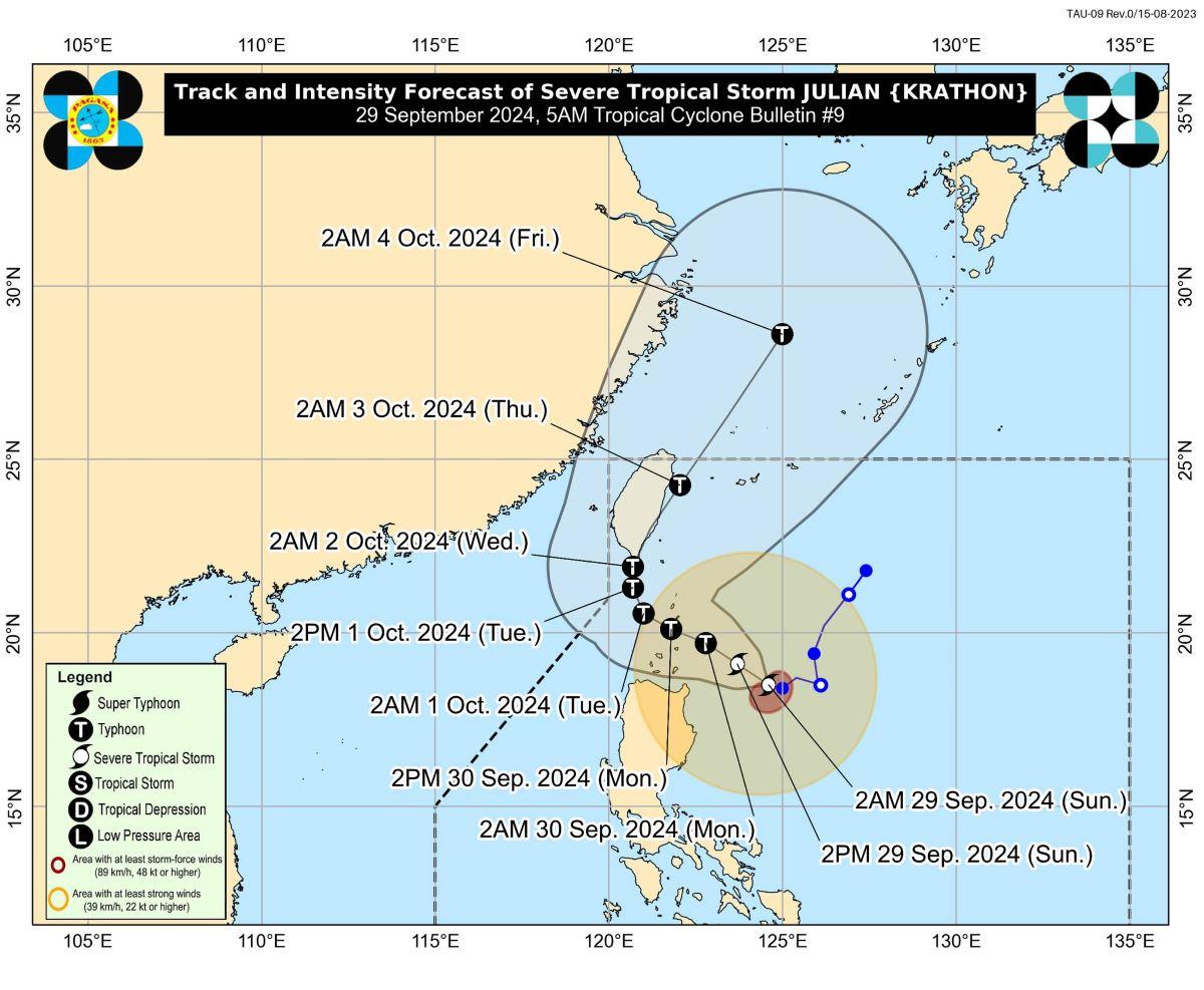
At 4 a.m., the center of Julian (international name: Krathon) was estimated to be located at 305 km east of Aparri, Cagayan.
Julian has maximum sustained winds of 95 km/h near the center, gustiness of up to 115 km/h, and central pressure of 990 hPa.
It is moving west northwestward at 10 km/h towards the Batanes-Babuyan Islands area.
From its center, strong to storm-force winds are extending outwards up to 450 km.
"On the track forecast, a landfall or close approach scenario by tomorrow (30 September) over Batanes and/or Babuyan Islands is highly likely," PAGASA said.
Julian may intensify further and become a typhoon on Sunday evening or Monday early morning.
However, "there is high chance of rapid intensification, and the possibility of reaching super typhoon category is not ruled out," PAGASA said.
Rainfall
Batanes and Babuyan Islands will have stormy weather on Sunday due to Julian, the weather bureau said.
Flash floods or landslides may result due to heavy to intense rains.
Mainland Cagayan, Isabela, Apayao, and Ilocos Norte may expect rains with gusty winds due to Julian. Moderate to heavy with at times intense rains may possibly result in flash floods or landslides.
Central Luzon, Quezon, Camarines Norte, Camarines Sur, Catanduanes, and the rest of Ilocos region, Cordillera Administrative Region, and Cagayan Valley will have cloudy skies with scattered rains and thunderstorms due to Julian. Moderate to at times heavy rains may possibly lead to flash floods or landslides.
Metro Manila and the rest of Luzon will also be affected by Julian, as these areas will have partly cloudy to cloudy skies with isolated rain showers or thunderstorms due to the trough or extension of Julian. During severe thunderstorms, flash floods or landslides may result.
Meanwhile, the rest of the country will have partly cloudy to cloudy skies with isolated rain showers or thunderstorms due to localized thunderstorms. Flash floods or landslides may possibly occur during severe thunderstorms.
Jebi
PAGASA is also monitoring Tropical Storm Jebi which is located outside the Philippine Area of Responsibility (PAR).
It was last estimated at 3 a.m. Sunday to be located at 2,075 km east of Extreme Northern Luzon, with maximum sustained winds of 65 km/h, gustiness of up to 80 km/h.
Jebi is moving northwestward at 25 km/h.
Coastal waters
PAGASA said a gale warning has been raised over the northern and eastern seaboards of Northern Luzon.
"Sea travel is risky for small seacrafts, including all types of motorbancas," it said.
The seaboards of Batanes and Babuyan Islands will have very rough sea condition. This makes it risky for most types or tonnage of vessels to travel by sea. PAGASA advised mariners to remain in port or seek safe shelter or harbor.
The northern seaboard of mainland Cagayan, northern seaboard of Ilocos Norte, and the remaining seaboard of Cagayan and the seaboard of Isabela will have rough sea condition over their coastal waters.
The remaining seaboard of Ilocos Norte will have moderate sea condition.
Central Luzon and the eastern section of Southern Luzon may have moderate to rough coastal waters.
The rest of the country meanwhile will have slight to moderate coastal waters.
Sunrise was at 5:46 a.m. while sunset will be at 5:47 p.m. —KG, GMA Integrated News
