

Signal No. 1 up over 3 areas as Julian traverses Philippine Sea
Tropical Cyclone Wind Signal No. 1 was raised over three areas early Saturday as Tropical Depression Julian traverses the Philippine Sea, PAGASA said in its 5 a.m. bulletin.
TCWS No. 1 was hoisted over the following areas:
- Cagayan including Babuyan Islands;
- the northeastern portion of Isabela (San Pablo, Divilacan, Maconacon, Palanan, Cabagan, Santa Maria, Tumauini, Ilagan City, San Mariano, Santo Tomas, Delfin Albano); and
- the eastern portion of Apayao (Luna, Pudtol, Santa Marcela, Flora).
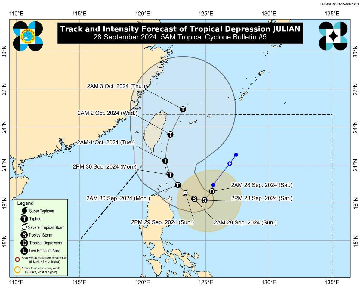
Julian maintained its strength while decelerating southward over the Philippine Sea.
The center of the eye of Julian was estimated to be located at 400 kilometers east of Aparri, Cagayan packing maximum sustained winds of 55 kilometers per hour near the center and with gustiness of up to 70 kph.
Julian was moving southward at 10 kph.
From its center, strong winds are extending outwards up to 360 km.
"Julian is forecast to follow a looping path over the waters east of Batanes and Cagayan in the next five days," PAGASA said.
It may possibly make landfall over Batanes by Monday afternoon or evening as a typhoon then exit the Philippine Area of Responsibility by Wednesday (2 October) evening to Thursday (3 October) early morning.
Severe winds
Areas under TCWS No. 1 will have strong winds in 36 hours, PAGASA said.
The strong winds with speeds of 39 to 61 km/h in these areas will pose minimal to minor threat to life and property.
PAGASA said the wind flow coming towards the circulation of Julian may also bring strong to gale-force gusts over the following areas, especially in coastal and upland areas exposed to winds, on Saturday: Aurora, Quezon, Camarines Norte, Camarines Sur, and Catanduanes.
Hazards affecting coastal areas
The seaboards of Batanes, Babuyan Islands, and the eastern seaboard of mainland Cagayan may expect rough seas with waves up to 4.0 m.
"Mariners of small seacrafts, including all types of motorbancas, are advised not to venture out to sea under these conditions, especially if inexperienced or operating ill-equipped vessels," PAGASA said.
Moderate sea condition meanwhile will be experienced over the coastal waters in the remaining seaboard of Cagayan and seaboard of Isabela
PAGASA issued a warning for mariners of motorbancas and similarly-sized vessels to take precautionary measures and if possible, avoid navigating.
"The hoisting of a Gale Warning is also increasingly likely over seaboards of Northern Luzon," the weather bureau said.
Tropical Storm Jebi
The weather bureau is also monitoring Tropical Storm Jebi, which is outside of the Philippine Area of Responsibility (PAR), at 2,405 km east of extreme Northern Luzon, packing maximum sustained winds of 75 kph and with gustiness of up to 90 and speed of 20 kph in the north northwestward direction.
Rains
Cagayan including Babuyan Islands will have rains with gusty winds due to Julian with the possibility of flash floods or landslides occurring due to moderate to heavy with at times intense rains.
Ilocos Norte, Ilocos Sur, Abra, Apayao, Kalinga, Mt. Province, Ifugao, Batanes, and Isabela will have cloudy skies with scattered rains and thunderstorms due to Julian with the possibility of flash floods or landslides occurring due to moderate to at times heavy rains.
Metro Manila and the rest of the country witll have partly cloudy to cloudy skies with isolated rain showers or thunderstorms due to localized thunderstorms with the possibility of flash floods or landslides occurring during severe thunderstorms.
Coastal areas
The wind speed forecast for Northern Luzon is moderate to strong and moving in the northeast to northwest direction with moderate to rough coastal waters.
The rest of Luzon will experience light to moderate wind speed moving in the northwest to southwest direction while coastal waters will be slight to moderate.
The Visayas and Mindanao will have light to moderate wind speed moving in the west to southwest direction while coastal waters will be light to moderate.
Sunrise will be at 5:46 a.m., sunset at 5:48 p.m.
Preparations
The provincial government of Cagayan said it has laid out preparations for the possible effects of Julian.
Food and non-food items have been prepositioned in the province's warehouses, Cagayan Provincial Disaster Risk Reduction and Management Office (PDRRMO) chief Ruelie Rapsing said on Saturday. — BAP/KG, GMA Integrated News
