

Igme out of PAR but enhanced Habagat to bring rains —PAGASA
Tropical Depression Igme left the Philippine Area of Responsibility on Saturday morning but the enhanced Southwest Monsoon (Habagat) will bring rains, PAGASA said in its weather bulletin.
PAGASA said Igme exited PAR at 2:30 a.m.
The tropical depression's eye was last estimated at 4 a.m. to be located at 520 km north northeast of Itbayat, Batanes.
Igme was moving northwestward at 40 km/h toward the East China Sea.
It has maximum sustained winds of 55 km/h near the center and gustiness of up to 70 km/h.
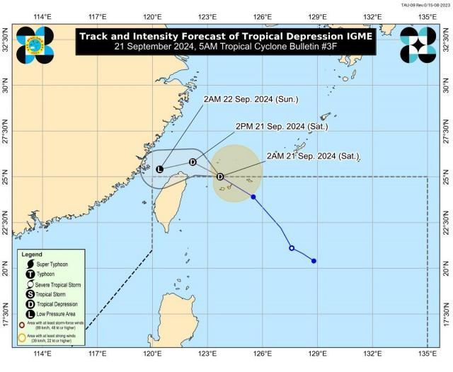
"Wala nang direktang epekto ito sa atin," DOST-PAGASA weather specialist Daniel James Villamil said in a briefing.
(It no longer has any direct effect on us.)
Meanwhile, the Southwest Monsoon being enhanced by Igme will bring strong to gale-force gusts over these areas, especially in coastal and upland areas exposed to winds: Ilocos Region, Abra, Benguet, Batanes, Babuyan Islands, the extreme eastern portion of Isabela, Nueva Vizcaya, and Zambales.
On Sunday, Ilocos Region, Abra, Benguet, Batanes, Babuyan Islands, mainland Cagayan, Isabela, Nueva Vizcaya, and Zambales will also experience strong to gale-force gusts.
Batanes and Babuyan Islands will have monsoon rains, with the possibility of flash floods or landslides due to heavy to intense rains.
Ilocos Region, Zambales, and Bataan will experience occasional rains due to the monsoon. Moderate to heavy rains may possibly lead to flash floods or landslides.
Metro Manila, the rest of Luzon, Western Visayas, Northern Samar, Eastern Samar, and Samar may expect cloudy skies with scattered rains and thunderstorms due to the Habagat. Moderate to at times heavy rains may possibly result in flash floods or landslides.
The rest of Visayas will have partly cloudy to cloudy skies with isolated rain showers or thunderstorms due to the monsoon. During severe thunderstorms, flash floods or landslides may result.
Mindanao on the other hand may have partly cloudy to cloudy skies with isolated rain showers or thunderstorms due to localized thunderstorms. Flash floods or landslides may possibly result during severe thunderstorms.
PAGASA raised a gale warning over the western seaboard of Ilocos Region.
"Sea travel is risky for small seacrafts, including all types of motorbancas," it said.
Coastal waters will be rough in the seaboards of Batanes, Zambales, Babuyan Islands, Bataan, Kalayaan Islands, and mainland Cagayan.
"Mariners of small seacrafts, including all types of motorbancas, are advised not to venture out to sea under these conditions, especially if inexperienced or operating ill-equipped vessels," PAGASA said.
Coastal waters will be moderate over the seaboards of Isabela and Lubang Island.
"Mariners of motorbancas and similarly-sized vessels are advised to take precautionary measures while venturing out to sea and, if possible, avoid navigation under these conditions," PAGASA said.
Meanwhile, coastal waters in the rest of Luzon will be moderate to rough coastal waters, and light to moderate in the rest of the country.
Sunrise was at 5:45 a.m. while sunset will be at 5:53 p.m. —KG, GMA Integrated News
